Stazerwald
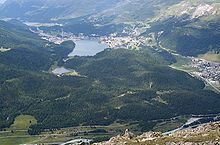
The Stazerwald ( Romansh God da Staz, pronunciation: ) is a wooded area in the Swiss canton of Graubünden . It is located on the northern slope of the Rosatsch Group in the Upper Engadin at an altitude of 1700 to 2100 m above sea level. M. The forest belongs mostly to the municipality Celerina / Schlarigna , smaller parts to St. Moritz and Pontresina .
nature
The landscape was largely shaped by the shaping activity of the Ice Age glaciers. In addition to round humps, there are damp depressions, flat and raised bogs. Of tree species prevail larch , mountain pine and Arve ago.
The Stazerwald belongs to the ecological emerald network , a pan-European network for the protection of endangered animal and plant species as well as habitats, and has been included in the federal inventory of landscapes and natural monuments of national importance (BLN). Large parts of the Stazerwald are defined as a game rest zone.
In the middle of the forest lies the approximately four hectare lake Staz (Lej da Staz) . The lake is at an altitude of 1809 m and is surrounded by moor meadows and reeds. Fever clover swims on the almost five meter deep lake .
tourism
The Stazerwald is accessible to tourists and athletes by hiking trails and cross-country skiing trails. The Engadin Skimarathon route leads through the Stazerwald .
A hotel-restaurant near the lake is open around eight months a year.
Railway construction
At the beginning of the 20th century it was initially planned to build the Bernina Railway , which was planned as a tourist summer railway, through the attractive Stazerwald. For environmental reasons, however, the much more expensive route around the Stazerwald through the Charnadüra gorge was chosen in the end. These sections on the edge of the Stazerwald were opened in 1908 (Pontresina - Celerina) and 1909 (Celerina - St. Moritz).
Web links
Individual evidence
- ↑ Swisstopo, accessed on February 15, 2014.
- ^ Website of Switzerland's wilderness areas, accessed on February 15, 2014.
- ↑ Engadin Skimarathon trail (Maloja - S-chanf) Description on engadin.stmoritz.ch, accessed on February 6, 2018
Coordinates: 46 ° 29 '46 " N , 9 ° 52' 8" E ; CH1903: 786 540 / 152322

