
Werbach quarry

The Werbach quarry is located near Werbach in the Main-Tauber district in Baden-Württemberg on the right slope of the Steckenleite above the Steckenleitegraben, the valley of which is separated from the Welzbachtal in the north by the Spornberg Höhberg . The outcrop of the quarry is considered worthy of protection and was therefore included as a geotope with the designation Steinbruch am Höhberg E von Werbach in the geotope cadastre of Baden-Württemberg. The quarry with gravel works is located on Steckenleite 1 .
history
A map from 1886 shows vineyards at the site of today's quarry. A quarry on Höhberg , which was still small at the time, was shown on a district overview map of Werbach from 1921 . After the Second World War , Emil Dengel founded a gravel works at the quarry , which was later taken over by his son Günther Dengel. On July 1, 1991, the plant was bought by Hohenloher Schotterwerke GmbH & Co. KG and taken over by Schotterwerke Hohenlohe-Bauland GmbH & Co. KG on January 1, 1992 .
After the takeover, the company was thoroughly modernized in the following decade until the turn of the millennium. In 1992 a new dedusting system and a new dosing system were purchased. In addition, the works entrance and the depot were renewed. In 1997 a HGT system followed, and in 2000 a new plant control system as well as a new recycling bunker with a feed line.
In 2011 Schotterwerke Hohenlohe Bauland (SHB) wanted to expand the quarry on Höhberg by 6.8 hectares. In 2012 the council of Werbach approved the extension. On December 21, 2012, an immission control permit was issued to expand the mining operations in an easterly direction. The existence of the ballast works is therefore considered to be secured for the next few decades. The Werbach quarry is the last limestone quarry in the Main-Tauber district, in which limestone gravel can be extracted for road construction and civil engineering for a long time .

View of the gravel works and quarry from the southwest
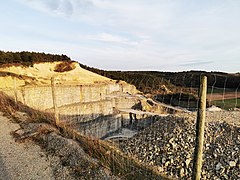
View into the quarry from the northwest
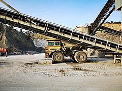
The loading system and a dump truck of the gravel plant
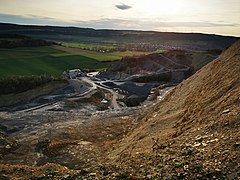
View over the quarry to the southwest into the Taubertal


Gravel works
In the stone quarry's gravel works, huge chunks of stone are loaded onto the so-called trough by large wheel loaders or dump trucks . This then feeds a crusher , which crushes the stones. The gravel is then either in a bulk - silo storage or through a funnel to the respective truck for further transport, for instance on building sites , charged.
Geological importance
Due to the gradual expansion of the Werbach quarry, several layers of rock have come to light on the quarry wall since the post-war period . The outcrop of the quarry offers an overview of some of the geological - geomorphological peculiarities of the natural area Tauberland of the Neckar and Tauber-Gäuplatten in the south-west German layer level country . For example, to recognize the quarry Werbach that the Lower Muschelkalk its largest size in the limestone - facies of the Tauber country with about 100 meters reached. From there, the thickness decreases towards the southwest and south to show values of 35 to 40 meters in the Freudenstadt Formation and Ühlingen facies of the southern Black Forest border. The State Office for Geology, Raw Materials and Mining (LGRB) describes the geoscientific importance of the Werbach quarry as follows:
“ Lower and middle shell limestone is exposed in the large quarry and gravel works on Höhberg approx. 1500 m east of Werbach . The quarry floor is only about 6 m above the border with the Upper Buntsandstein . Above the lower wave limestone ( Jena formation ) follow the Buchimergel with a thickness of up to 6.2 m, above that wave limestone up to the border with the Middle Muschelkalk. Several guide banks can be seen quite well in the dismantling wall, such as the lower and upper spiriferina banks as well as the lower and upper limestone banks. Above it, the Middle Muschelkalk begins with the Karlstadt Formation , which is then followed by the Lower Dolomites . The saline formation here is heavily leached and consists of gypsum residues from dolomitic, silty-clayey leachate rocks . In the higher overburden area, dolomite stones of the Upper Dolomite Formation finally appear. "
The quarry is the only almost complete exposure of the Lower Muschelkalk in Baden-Württemberg. Therefore, as well as due to its specific location in the transition area between the southern and northern German rock formation, it is of great scientific importance.
See also
Web links
- Lower and middle shell limestone near Werbach in the large quarry and gravel works on the Höhberg on the website lgrbwissen.lgrb-bw.de
Individual evidence
- ↑ a b c d e f Werbach, SHB GmbH & Co. KG. In: shb-schotter.de. Retrieved April 22, 2021 .
- ↑ gtk_2504.pdf. (PDF) In: media.lgrb-bw.de. Retrieved April 22, 2021 .
- ↑ Geotopes in the Stuttgart administrative region. (PDF) Retrieved April 23, 2021 .
- ^ SHB gravel works - Werbach municipality. In: werbach.de. Retrieved April 23, 2021 .
- ↑ Land use 1886 according to: Meßtischblatt 6323 Tauberbischofsheim from 1886 in the Deutsche Fotothek
- ^ Landesarchiv Baden-Württemberg, Department General State Archive Karlsruhe - Documents - District overview plan Werbach. In: .landesarchiv-bw.de. 1921, accessed April 21, 2021 .
- ↑ Expansion of the quarry advanced. In: mainpost.de. Retrieved April 22, 2021 .
- ↑ The quarry is to be almost seven hectares larger. In: main-echo.de. Retrieved April 22, 2021 .
- ↑ On the trail of concrete - Werbach - news and information. In: fnweb.de. Retrieved April 25, 2021 .
- ↑ a b c Lower and Middle Muschelkalk near Werbach. In: lgrbwissen.lgrb-bw.de. Retrieved April 22, 2021 .
- ↑ Building land and Tauberland - 14729. In: lgrbwissen.lgrb-bw.de. Retrieved April 24, 2021 .
- ↑ a b Lower Muschelkalk - 15504. In: lgrbwissen.lgrb-bw.de. Retrieved April 24, 2021 .
- ↑ Lower and Middle Muschelkalk near Werbach - 23665. In: lgrbwissen.lgrb-bw.de. Retrieved April 22, 2021 .
- ↑ gtk_2504.pdf. In: media.lgrb-bw.de. Retrieved April 22, 2021 .
Coordinates: 49 ° 39 ′ 52.6 " N , 9 ° 39 ′ 36.7" E