
Stemwede
| coat of arms | Germany map | |
|---|---|---|

|
Coordinates: 52 ° 25 ' N , 8 ° 29' E |
|
| Basic data | ||
| State : | North Rhine-Westphalia | |
| Administrative region : | Detmold | |
| Circle : | Minden-Lübbecke | |
| Height : | 42 m above sea level NHN | |
| Area : | 166.13 km 2 | |
| Residents: | 13,020 (Dec. 31, 2019) | |
| Population density : | 78 inhabitants per km 2 | |
| Postal code : | 32351 | |
| Primaries : | 05474, 05773, 05745 | |
| License plate : | MI | |
| Community key : | 05 7 70 044 | |
| LOCODE : | DE SMW | |
| Community structure: | 3 districts and 13 localities | |
| Address of the municipal administration: |
Buchhofstrasse 13 and 17, Stemwede-Levern 32351 Stemwede |
|
| Website : | ||
| Mayor : | Kai Abruszat ( FDP ) | |
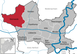
| Location of the municipality of Stemwede in the Minden-Lübbecke district | ||
  |
||

Stemwede [ ʃtɛmˈveːdə ] ( Low German : Stemwäide ) is a municipality in North Rhine-Westphalia . It belongs to the district of Minden-Lübbecke in the Detmold administrative district in East Westphalia-Lippe .
The municipality is one of the most sparsely populated municipalities in North Rhine-Westphalia. The districts of Levern , Destel and Wehdem were first mentioned in 969. Today's municipality of Stemwede was created in 1973 through the merger of the thirteen municipalities of the former Levern and Dielingen-Wehdem offices .
geography
Geographical location

Stemwede is located in the northeast part of the state of North Rhine-Westphalia . The municipality is located in the north of Ostwestfalen-Lippe ( Detmold administrative district ) and in the northwest of the Minden-Lübbecke district . It extends within the Dümmer Nature Park near the " North Rhine-Westphalia Point ", which marks the northernmost part of the country. The closest major cities are Osnabrück (30 km southwest) and Bielefeld (45 km south).
Stemwede belongs cultural space to the landscape of Minden country . In terms of its natural surroundings , the municipality lies entirely in the geest landscapes of the North German Plain . The area belongs to the natural subunit Dümmer-Geestniederung . The eponymous Dümmer is about 4 km north of the community. The Dümmer-Geest lowland can be divided into two natural areas in the municipality. Stemwede is therefore largely located in the Rahden-Diepenauer Geest sub -area . In the north of the municipality, the area already merges into the Diepholzer Moorniederung .
The municipality is mostly flat, there are hardly any elevations. The exception is the Stemweder Berg (also called "Stemmer Berge") in the north, the highest mountain of which is the Kollwesshöh near Westrup , 181.4 m above sea level. Has NN ; its north-western neighbor is the sharp mountain ( 180.1 m above sea level ). This small mountain range is an isolated branch of the low mountain range . To the south of it are the Leverner Hügel , the Sunderner Hügel and the Dielinger Klei to the west, which are smaller elevations that hardly rise above the area. In the northeast of the municipality, the Oppenweher Moor and the lowest point of the municipality extends at around 38 m above sea level. NN . In total, only around 6.5 km² (less than 4%) are higher than 100 m above sea level in the municipality . NN and only around 1.5 km² (less than 1%) higher than 150 m above sea level. NN .
Most of the waters in the municipality are canals that drain the area at regular intervals. They were created artificially and do not form a classic river system of tributaries and main rivers that results from the direction of flow. The largest river in the true sense of the word is therefore the Great Dieck River , which flows from the south through the municipality towards the northeast. Most of the water bodies in the east of the municipality drain into it. Some of the streams in the southeast of the municipalities, such as the Große Dieck River, also drain directly into the Große Aue , which flows past Stemwede in the east near the municipality boundary. To the west, the municipality is located in the catchment area of the Hunte , which flows past Stemwede about 400 m beyond the eastern municipality limits. The community area therefore belongs to the catchment area of the Weser .
See also: Natural spaces in OWL , waters in OWL

Seen from the Wiehengebirge , the Stemweder Berg stands out clearly in the North German Plain as an isolated mountain range

The Scharfe Berg , the highest point on the Stemweder Berg

Landscape in the Oppenweher Moor
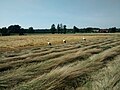
Three storks in the field in Twiehausen


Land use

With 81 inhabitants / km², Stemwede is the most sparsely populated municipality in the district. This fact is all the more remarkable because the municipality has comparatively few forest areas, but an above-average amount of basically colonizable land. Approx. 6000 inhabitants, i.e. almost half of the population, are concentrated in the three largest towns Levern, Dielingen and Oppenwehe. Large areas in the central area of the municipality and in the far north, however, have an extremely low population density. The only larger forest areas are the wooded Stemweder Berg and the Lever Forest near Levern . The following table provides an overview of the land use:
| Area according to type of use |
Agricultural area |
Forest area |
Settlement and traffic areas |
Surface of water |
other use |
|---|---|---|---|---|---|
| Area in ha | 12,413 | 1,804 | 1,837 | 384 | 175 |
| Share of total area | 74.7% | 10.9% | 11.1% | 2.3% | 1 % |
Source: LDS
geology

The geological structure of the area is relatively uniform. Most of the parts are made of Quaternary rocks . The Stemweder Berg and individual elevations south of it at Levern ( Leverner Hügel , Sunderner Hügel , Dielinger Klei ) are made up of layers of the uppermost chalk . The floors consist predominantly of geest floors . These are sandy and not very fertile. In the moorland, the area can only be used extensively for agriculture.
Stemwede is well to very well suited for the use of geothermal heat sources by means of a geothermal probe and heat recovery by means of heat pump heating systems (see the adjacent map).
Expansion of the municipal area
The municipality covers an area of 166.13 km². The community extends around 17 km in north-south direction. The west-east extension is a maximum of about 17 km.
Neighboring communities
Stemwede borders in the east on Rahden and Espelkamp and in the south on Preußisch Oldendorf (all district of Minden-Lübbecke ). In the west and north, Stemwede borders the following municipalities in Lower Saxony in a clockwise order : Bad Essen , Bohmte (both districts of Osnabrück ), Lemförde , Brockum , Stemshorn and Quernheim (to the combined municipality of Altes Amt Lemförde ) and Wagenfeld (Altes Amt Lemförde and Wagenfeld to the district of Diepholz ) .
Community structure

On January 1, 1973, due to the Bielefeld Act, the former offices of Dielingen-Wehdem and Levern were merged to form the municipality of Stemwede, the municipal administration is located in Levern. The area of the municipality of Stemwede is divided into the following districts and localities according to § 12 of the main statute:
- Levern district with the villages of Levern , Sundern , Niedermehnen , Destel and Twiehausen
- Dielingen district with the villages of Drhne , Dielingen , Haldem and Arrenkamp
- Wehdem district with the villages of Westrup , Wehdem , Oppendorf and Oppenwehe
| District | Residents | proportion of | surface | Population density |
|---|---|---|---|---|
| Levern | 2,250 | 15.52% | 10.93 km² | 205.86 inhabitants / km² |
| Sundern | 300 | 2.07% | 8.68 km² | 34.56 inhabitants / km² |
| Niedermehnen | 590 | 4.07% | 13.05 km² | 45.21 inhabitants / km² |
| Destel | 600 | 4.14% | 8.70 km² | 68.97 inhabitants / km² |
| Twiehausen | 550 | 3.79% | 16.17 km² | 34.01 inhabitants / km² |
| Levern district | 4,290 | 29.59% | 57.53 km² | 74.57 inhabitants / km² |
| drone | 500 | 3.45% | 11.14 km² | 44.88 inhabitants / km² |
| Dielingen | 2,150 | 14.83% | 7.82 km² | 274.94 inhabitants / km² |
| Haldem | 1,850 | 12.76% | 18.94 km² | 97.68 inhabitants / km² |
| Arrenkamp | 280 | 1.93% | 5.52 km² | 50.73 inhabitants / km² |
| Dielingen district | 4,780 | 32.97% | 43.42 km² | 110.09 inhabitants / km² |
| Westrup | 580 | 4.00% | 6.21 km² | 93.40 inhabitants / km² |
| Woe | 1,750 | 12.07% | 13.07 km² | 133.89 inhabitants / km² |
| Oppendorf | 850 | 5.86% | 17.99 km² | 47.25 inhabitants / km² |
| Oppenwehe | 2,250 | 15.52% | 27.90 km² | 80.65 inhabitants / km² |
| Wehdem district | 5,430 | 37.45% | 65.17 km² | 83.32 inhabitants / km² |
| Stemwede municipality | 14,500 | 100% | 166.13 km² | 87.28 inhabitants / km² |
climate

The climate in Stemwede is determined by its location in the ocean-continental transition area of Central Europe and by its location in the North German Plain. The area is mostly in the sub-Atlantic maritime climate , but has temporary continental influences . The winters are mostly mild under the influence of the Atlantic, the summers are moderately warm and the rainfall is relatively evenly distributed. Westerly and southwesterly winds predominate, which bring precipitation with them. Overall, the climate for Stemwede hardly differs from the climate of neighboring Rahden , which is located in an identical natural area. The mean annual temperature is around 9.3 ° C; in the area of the Stemweder Berg by up to 0.5 ° C colder. The average annual rainfall is around 650 mm in the east of the municipality and around 700 mm in the west and north of the municipality. This makes the east of the municipality one of the driest and warmest areas in East Westphalia .
See also: Climate in Ostwestfalen-Lippe
history

Already around 800 Dielingen became one of the oldest parishes in pagan Saxony, conquered by Charlemagne. Predecessors of today's St. Marien Church in Dielingen can be traced back to this time, i.e. as old as the first cathedrals in Cologne , Paderborn , Osnabrück and Minden .
In a document from the bishop in 969 it was reported that Knight Worad donated various courtyards, serfs and others to the Minden Cathedral . Bishop of Minden at that time was Milo von Minden . The villages Levern, Destel and Wehdem were first mentioned in this document. For the year 1055 is reported the bishop Egilbert of Minden possesses in Arnicambe a Vorewerch . In 1198 the name Stemwede was mentioned for the first time in the Osnabrück record book. Finally, a knight Wulfried de Arnechamp is named for the year 1222 , who appears as a witness and in 1224 sold a house in Arrenkamp to the Osnabrück Cathedral Chapter. In 1227 Konrad I von Rüdenberg , Bishop of Minden, founded a Cistercian convent in Levern, for which Pope Gregory IX. 1228/31 issues letters of protection. In the 13th century the foundation stone of the St. Marien Church in Dielingen and the construction of the castle in Haldem took place by the bishops of Minden. In 1368 jurisdiction in the Free County of Stemwede passed to the bishop and the chapter of the diocese of Minden . The area became an integral part of the Principality of Minden . In 1558, in the course of the Reformation , the monastery in Levern was converted into a free world, aristocratic women's monastery. The area of today's Stemwede fell to Brandenburg-Prussia in 1648 together with the prince-bishopric of Minden, now the principality of Minden .
In 1806 Napoleon conquered the area and today's Stemwede became part of the Kingdom of Westphalia ( Département du Weser ) in 1807 , and from 1811 it was incorporated into the French Empire ( Département de l'Ems-Supérieur ). In 1810 Napoleon Bonaparte abolished the women's monastery . After the end of Napoleonic rule, the area became Prussian again in 1813. By 1816 the administrative structures were reorganized; the area was now in the northeast of the Prussian province of Westphalia and in the new Rahden district (later renamed the Lübbecke district ). From 1843 the area of today's municipalities was organized into the offices of Dielingen, Wehdem and Levern. Dielingen and Wehdem were temporarily merged again and again in personal union, for example in 1936. Within the offices, the current districts as well as the Haldem manor district existed as an independent municipality or manor district.
In the period from 1895 to 1910, there was considerable emigration to the province of Posen, sponsored by the Prussian Settlement Commission .
On December 16, 1943, a British bomber loaded with a 1,800 kg high explosive bomb and many incendiary bombs crashed in Oppendorf. 19 farmsteads were destroyed and people (no uniform number of fatalities) were killed. This should not be the only war destruction in the area of today's municipality of Stemwede. Because on April 4, 1945 there was fighting in Levern when German soldiers attacked the British vanguard. 10 German soldiers, 6 members of the British armed forces and 6 civilians died in the fighting and over 50 buildings in Levern and the surrounding villages were destroyed or damaged.
The administrative division described above survived until January 1, 1973, when, according to the Bielefeld Act, the area of the aforementioned offices was combined to form the municipality of Stemwede and became part of the new Minden-Lübbecke district . The name Stemwede indicated the late medieval free county of Stemwede .
Religions
The population is predominantly Evangelical-Lutheran after the prince-bishopric of Minden accepted the evangelical doctrine and at the latest since it was secularized in 1648 and was added to Protestant Prussia as the Principality of Minden . The Protestants are organized in the parishes Evangelical Lutheran Church Congregation Oppenwehe , Evangelical Lutheran Church Congregation Levern , Evangelical Lutheran Church Congregation Dielingen and Evangelical Lutheran Church Congregation Wehdem . The first organized Islamic community in Stemwede was founded in the 1990s on the initiative of DİTİB. There is a mosque where the Friday sermons are given. Other religious communities do not have a seat and / or church building in Stemwede.
An indication of the distribution can be the denomination of the Stemweder students. According to this, around 78.9% of the students are Protestant, 6.7% Catholic, 2.5% Islamic. 3.9% say they belong to another denomination, and 7.8% do not belong to any denomination.
According to the results of the census of May 9, 2011, 10,450 inhabitants (75.5%) were Protestant, 870 were Catholic (6.3%) and 2520 people (18.2%) gave no or other information about their religion.
Incorporations

Before the municipal reform and the reorganization of the area with effect from January 1, 1973 (see Bielefeld Act ), the current localities formed independent municipalities in the Dielingen-Wehdem (municipalities Arrenkamp , Dielingen , Drhne , Haldem , Oppendorf , Oppenwehe , Wehdem and Westrup ) and in the Levern district (municipalities of Destel , Levern , Niedermehnen , Sundern and Twiehausen ). In addition to smaller, insignificant land consolidations on this date, a small part in the east of Oppenwehes was reclassified into the town of Rahden, which was formed on January 1, 1973. After January 1, 1973 there were no further reclassifications or incorporations into the municipality.
Population development

The following overview shows the population of the municipality of Stemwede and from 1939 to 1970 the population of today's municipality and before 1939 the population of the municipalities of the offices of Dielingen and Levern (different territorial status). The figures are census results up to 1970 and for 1987 as well as 2011 and from 1975 official updates of the State Office for Data Processing and Statistics. The figures from 1975 to 1985 are estimated values, the figures from 1990 onwards based on the results of the 1987 census. The data relate to the resident population and from 1985 to the population at the place of the main residence .
|
|
politics
mayor
On August 30, 2009 Gerd Rybak (CDU) was elected the new mayor with 60.24 percent. He replaced Ekkehardt Stauß (CDU), who was directly elected by the citizens for a second term in 2004 with 77.4 percent of the valid votes in the first ballot. In 1999, Stauß became the first directly elected full-time mayor of the municipality, who has also been the head of the municipal administration since then. In return, the office of the community director was abolished. On September 2, 1999, Stauß received 77.6 percent of the valid votes. Stauß had been the parish director of the parish since 1985. The first mayor of the municipality of Stemwede after the foundation of the municipality was Heinz Becker. He was replaced in 1994 by Günter Heselmeier. Heinz Becker is honorary mayor of the community. In the mayoral election on September 13, 2015, Kai Abruszat , member of the FDP state parliament, was elected the new mayor with 56.8% of the vote.
Municipal council
municipal council 2014
- Greens: 3
- SPD: 9
- FWG: 2
- FDP: 3
- CDU: 15
The Stemwede municipal council currently has 32 seats. In addition, the mayor is the council chairman. The following table shows the local election results since 1975:
| 2014 | 2009 | 2004 | 1999 | 1994 | 1989 | 1984 | 1979 | 1975 | ||||||||||
|---|---|---|---|---|---|---|---|---|---|---|---|---|---|---|---|---|---|---|
| Political party | Seats | % | Seats | % | Seats | % | Seats | % | Seats | % | Seats | % | Seats | % | Seats | % | Seats | % |
| CDU | 15th | 47.92 | 17th | 51.87 | 20th | 61.37 | 21st | 66.41 | 19th | 54.22 | 19th | 54.56 | 20th | 58.88 | 20th | 61.93 | n / a | 65.77 |
| SPD | 9 | 26.83 | 7th | 22.31 | 7th | 22.40 | 8th | 24.25 | 10 | 30.50 | 10 | 29.36 | 9 | 29.01 | 9 | 27.23 | n / a | 24.13 |
| FDP | 3 | 9.62 | 4th | 12.36 | 3 | 9.66 | 1 | 4.14 | 2 | 7.52 | 3 | 11.05 | 4th | 12.10 | 4th | 10.84 | n / a | 9.75 |
| Green | 3 | 9.74 | 2 | 6.49 | 2 | 6.58 | 2 | 4.67 | 2 | 7.77 | 1 | 5.03 | - | - | - | - | - | - |
| FWG 1 | 2 | 5.88 | 2 | 5.60 | - | - | - | - | - | - | - | - | - | - | - | - | - | - |
| REP | - | - | 0 | 1.36 | - | - | - | - | - | - | - | - | - | - | - | - | - | - |
| Individual applicants | - | - | - | - | - | - | 0 | 0.53 | - | - | - | - | - | - | - | - | - | - |
| Others | - | - | - | - | - | - | - | - | - | - | - | - | - | - | - | - | n / a | 0.36 |
| Total 2 | 32 | 100 | 32 | 100 | 32 | 100 | 32 | 100 | 33 | 100 | 33 | 100 | 33 | 100 | 33 | 100 | n / a | 100 |
| voter turnout | 50.17 | 56.18 | 54.46 | 58.31 | 80.32 | 67.25 | 68.79 | 72.16 | 86.16 | |||||||||
1 Free voter community Stemwede
2 without taking into account rounding differences
coat of arms
According to the main statute of the municipality of Stemwede from November 18, 1999 § 2, the municipality of Stemwede was granted the right to use a coat of arms, a flag and a banner with a certificate from the district president dated February 6, 1975. Description of the coat of arms : In blue above a golden (yellow) three-mountain a golden (yellow) overturned sword, accompanied by two silver (white) lilies.
The Dreiberg stands for the Stemweder Berg . The sword symbolizes the judiciary; The place of justice used to be the district of Wehdem. The sword comes from the seal of Gehrke Wedeham from 1441, who was a judge in Wehdem. This sword was already included in the coat of arms of the Dielingen-Wehdem office. The lilies are taken from the coat of arms of the Abbey of Levern and point to the monastic past of this district.
The flag is striped lengthways in white and blue in a ratio of 1: 1 with the coat of arms of the municipality shifted from the center to the pole.
Town twinning
The municipality of Stemwede has a partnership with the French municipality of Lardy . This was sealed in January 2018, almost 55 years to the day after the signing of the Élysée Treaty by Stemwede's Mayor Kai Abruszat and his French counterpart Dominique Bougraud.
Culture and sights


theatre
The Heimatbühne Stemweder Berg organizes Low German theater afternoons and evenings. The amateur play group Oppenwehe gives performances in Advent. The amateur play group “Kleine Bühne” of the Landjugend Levern will perform plays in High German and Low German in the “small hall” of the festival hall in Levern.
Museums
The Levern home building in the former rectory from 1714 deals with the history of the monastery and monastery town of Levern. In the local history museum exhibits on housekeeping , weaving and spinning and the traditional costumes of the region are on display.
The Heimathaus Wehdem, which is also used as a wedding room, shows an exhibition about life, work and traditional costumes from earlier times. The old Wehdem church clock and documents about those who emigrated to America from Wehdem are also on display.
In the Rural Museum on the grounds of the Kolthoff Mill in the village of Levern, various testimonies of rural culture are presented in a hall that was inaugurated in 2008. The focus of the museum is the permanent exhibition “From Grain to Bread”, which traces the regional grain cultivation from the sowing to the utilization as baked goods and animal feed . Attached to this is a collection of historical agricultural equipment and machines that characterize various milestones in the mechanization of agriculture. Since 2013 a saw frame building with a historical horizontal frame saw has been added to the museum's offer. There are also demonstrations of old village handicrafts on milling and baking days.
The German Wind Power Museum in the village of Oppendorf explains the historical roots of modern wind energy use . Wind power plants from the 1980s and 1990s form the cornerstone for today's success of wind energy in Germany. Preserving and caring for them is the core task of the museum. The German Wind Power Museum e. V. runs the museum and was founded in 1997.
Churches
Evangelical Church of St. Mary
The Protestant Church of St. Marien in Dielingen with its historic church square was built around 1225 as a late Romanesque hall church with a large west tower. Around 1400 the church got its present appearance through cross arms (cross shape) and the transition to the Gothic style. It had two or three previous churches and is the oldest church in Stemwede. The first previous building probably dates from around 800. Dielingen was one of the oldest parishes in pagan Saxony, conquered by Charlemagne. Until 1770 there was another church, the Holy Cross Church, only about 20 meters northwest of St. Mary's Church, which was first mentioned in 1243 in connection with the preacher Ludolfus von Dielingen. In the 10th to 12th centuries, the Dielingen parish extended to Rahden in the east, to Burlage in the north and Meyerhöfen / Schwege in the west. In the church there is u. a. a baroque organ from the beginning of the 17th century, a chandelier in the nave of the St. Matthias Brotherhood in Dielingen, which is still active today, from 1663 and a window from around 1900, which shows "Jesus in the clothes ".
Holy Cross Chapel in Haldem
The Haldem Holy Cross Chapel was built in the second half of the 15th century and has a wooden beam ceiling from 1621 and a half-timbered gable.
The parish was mentioned under Bishop Milo von Minden (969-996). Although no church building is documented at this time, it can be assumed that the name Wehdem is derived from the name Wedum according to the church book , synonymous with: "Consecration" or "Sanctuary of God". According to a document, Wehdem's church property was sold to the Levern monastery in 1330, which proves the construction of the “first” church in Wehdem. Nevertheless, a church must have existed in Wehdem before, because a plebanus (Lord of the Church) is mentioned in Wehdem as early as 1283 . 1801–1803 a new church was built; the tower followed in 1853–1855. This new church was higher up on the mountain than the old one from 1330. The altar from 1605 and other parts of the interior are from the old church. The transverse sermon hall, which is unusual for Westphalia, contains the organ front with a baroque front view from 1662. The new organ by the organ builder Johannes Wolfram from Osnabrück was built in 1971.
Evangelical parish and collegiate church in Levern
In the center of Levern and on the Levern hill are the historic buildings of the women's monastery with a double church (consisting of a parish church and a monastery church). The first mention of a church (probably a wooden church until around 1000) is found under Bishop Milo von Minden (969-996). Today's irregular, three-aisled hall church emerged from completely separate independent churches until 1828. On the one hand, there was the three-bay, two-aisled late Gothic parish church from the late 15th century. The establishment of the parish church goes back to the 17th century. On the other hand, this was the collegiate church consecrated on May 1, 1283 by Bishop Volquin von Schwalenberg . Its vaulted rectangular hall without a choir forms the north aisle of today's double church. Between 1283 and 1558 the collegiate church served as the monastery church of the Levern monastery and then from 1558 to 1810 as the collegiate church of the free worldly women's monastery . Today's church with thick walls dates from around 1500 and was already built as a double church. In 1582 the old tower was raised and reinforced. The sacristy dates from 1603, the Baroque tower dome from 1715. In 1679 the church and monastery in Levern were destroyed by the French. The galleries and the associated staircases inside were built in 1914 to create more space in the church. Many former monastery buildings have been preserved around the church and form the core of the "Abbey Village of Levern", which is worth seeing.
Martini Church in Oppenwehe
The Martini Church in Oppenwehe , completed in 1931, renovated and rebuilt in 1967, replaced the half-timbered Oppenweher Klus from 1699 (possibly also 1648), which at that time was still part of the Wehdem parish. The Oppwenweher parish has been independent since 1961. The Martini Church has some windows from the old Klus. The Klus also had a predecessor. This oldest chapel already existed before 1330, when the newly built church was first mentioned in Wehdem and became the main church of the parish of Wehdem (to which Oppenwehe was also assigned). From then on, the old Oppenweh chapel was probably only used sporadically and possibly destroyed in the Thirty Years War .
music
In Stemwede there is a branch of the music school association of the cities Espelkamp and Rahden and the municipality of Stemwede. There are also two festivals and other musical events in Stemwede, which are organized by two cultural associations (see regular events ).
Haldem Castle
Haldem Castle is an old manor of the Minden bishops on the southern slope of the Stemweder Berg from the 13th or 14th century. The building substance in the Baroque style originates mainly from the year 1703. The castle was mentioned for the first time in 1236, served as a women's monastery and today houses a penal institution.
Mills
There are still three mills in Stemwede, all of which are part of the Westphalian Mill Road . The mill in Destel is a gallery Dutch and was built at the beginning of the 19th century in half-timbered construction. The original technology was removed from the octagonal clapboard building.
The Oppenwehe post mill was built in 1705 and completely restored from 1989 to 1992. The technology of the mill has been preserved and the mill is still grindable. The mill has two side pockets and is probably the last mill of its kind with the special side pockets in the old federal states.
The Kolthoffsche Hofmahlmühle in Levern was built in 1922 and operated until 1959. The Dutch gallery windmill was moved and restored in 1980/81.
Buildings
- The former largest wind power plant in the world is located in drone . Other outstanding buildings or sights are:
- Old rectory in Dielingen: The house was built in 1834 and is a strikingly wide half-timbered house . It was restored in 1985/86 and is now used as a brewery and library.
- Haus des Gastes / Altes Amtshaus Levern: The house was built at the end of the 17th century and previously also served as a post office for changing horses and an inn. The strong cantilevered gable shows many decorations and inscriptions.
- Hereditary burial sites of the von dem Bussche -Ippenburg and von der Horst families
- Barrow on the Schlichten Brink (also known as a barrow ) (17 meters in diameter) from the younger Bronze Age (1500 BC to 500 BC) near Arrenkamp on the Weißen Weg in the Stemweder Berg. During excavations by Friedrich Langewiesche in 1935, only the remainder of an urn was found. Therefore, it is believed that the tomb was robbed by grave robbers.
Several districts of Stemwedes (Levern, Destel, Drone, Haldem, Niedermehnen, Oppendorf, Wehdem, Westrup) are award winners in the competition Our village should become more beautiful .
Parks
Haldem Castle Park
The park belonging to Schloss Haldem is around 8 hectares in size. The origins and the original shape of the garden are in the dark. One suspects a baroque garden. Around 1910 the eastern part of the park was designed as a 3-hectare landscape park, as well as parts of it as kitchen and farm gardens. The park was used as a shooting range in the Third Reich , when a Hitler Youth driving school was housed in the castle , and the landscape park was destroyed, but no later than during the British occupation from April 1945. Only a few elements of the historical landscape park were preserved and some modern elements were added Close to the building added.

Park of the Levern sulfur plant
The approximately 4 hectare facility was built around a natural sulfur and radiation source , which in 1835 established a small farmer's pool. This facility was expanded from 1930–1932 and a bathhouse was added in 1951. A 500 meter long avenue between Levern and Bad is particularly noticeable in the park. Around the bath house there are some green areas with circular hiking trails and shrub beds.
Nature and natural monuments
In Stemwede there are the four nature reserves Oppenweher Moorlandschaft (492 hectares, high moor and wet meadows), Rethlage (43 hectares, partly in Espelkamp, wet meadows and forest), Lever Teich-Lever Bruch (20 hectares, wet meadows and bodies of water) and Stiftholz (12 hectares ; Forest, transitional moor, water and grassland). The Oppenweher Moor, which is protected in Stemwede on an area of 215 hectares (with adjoining wet meadows 492 hectares), lies northeast of the Stemweder mountain. Since the moor plants are extremely sensitive to the impact of foot traffic, visitors are only allowed to use the paths marked on the hiking boards and leaflets. In the northwest at Stemweder Berg and near the Hunte, Stemwede is part of the Dümmer Nature Park .
There are 31 natural monuments in the municipality . These are made up of 29 solitary trees and groups of trees, including the oaks in the Badeallee in Levern, and two old quarries in Haldem, which are designated as geological objects.
Sports
The municipality of Stemwede is a prizewinner in the state competition The sporty municipality . 63 percent of the population are members of 29 sports clubs within the community. The annual International Junior Whitsun Tournament is one of the largest sporting events. This is known in football circles far beyond Germany and Europe. In 2007 it took place for the 30th time in Wehdem. In Oppenwehe there is a state performance base in North Rhine-Westphalia for sport shooting.
The largest sports clubs in Stemwede include the TuS Stemwede (1st men's team plays in the district league B), FC Oppenwehe (1st men's team plays in the district league B), the TuS Levern (1st men's team plays in the district league A), the TuS Dielingen (1st men's team plays in the district league) and the TV "Frisch Auf" Levern von 1913 e. V. (volleyball, gymnastics, swimming).
Regular events

The Stemweder Open Air has been held annually in August in Haldem since 1976 and attracts over 20,000 visitors as a free-and-outside festival.
The association for youth, leisure and culture in Stemwede e. V. (or JFK Stemwede) with around 400 members organizes the Stemweder Open Air , the holiday games, the youth bistro Life House and other cultural events such as the culture days and the Stemweder biker meeting. The Stemweder Kulturring has 70 members and organizes numerous cultural events, including an annual cabaret by the Minden sticklebacks .
The Waldfrieden Wonderland is an open-air music festival with the main musical style psychedelic trance .
The Leverner Markt festival takes place annually in October and includes a trade show. The Oppenweher Bünselmarkt is an annual folk festival that takes place in September. As part of the market, u. a. organized a lawn tracker race, a village evening and a tent service. The market is already over 250 years old and was formerly primarily a cattle market . The trade in cattle is now in the background. During the Advent season, three Christmas markets take place in the community: the Oppenweher "Advent an der Klus", the Dielinger Advent and the Levern Christmas market.
Culinary specialties
The Oppenweher asparagus is known nationwide and is grown on the sandy soils of the community. East Westphalia’s largest asparagus market takes place in Stemwede in May.
Economy and Infrastructure
traffic
The closest train station in Lemförde is on the Bremen - Osnabrück railway line . The route leads through Dielingen and cuts the village into two parts. There is a depot in drone , which serves as an alternate depot for the busy main line. The train station is without passenger traffic. Regional buses go to Lemförde , Rahden , Lübbecke and Espelkamp . Stemwede is connected to the B 51 , B 239 , B 61 and B 482 via the well-developed state road 770 ( Bohmte -Espelkamp- Petershagen ) . The next major airports are in Münster-Osnabrück and Bremen .
The national cycle routes Hanover-Steinhuder Meer-Dümmer See and the mill route lead through Stemwede . The Ems-Hase-Hunte-Else-Weg long-distance hiking trail also runs through the community .
Established businesses
The largest company in Stemwede is ZF Friedrichshafen AG , which in Dielingen with around 1900 employees develops and produces chassis components for cars, trucks and buses. The second largest employer in the area is Depenbrock Bau GmbH & Co. KG, which has around 870 employees, although not all of them work at the headquarters in Stemwede. In addition to these two larger companies, there are essentially only smaller, medium-sized companies in Stemwede. The OKT Group with its headquarters and one of three locations in Oppenwehe employs around 450 people across Europe. The OPTIFIT Jaka Group, which has been based in Wehdem for over forty years, currently employs around 300 people.
The central administration and logistics center of Rila Feinkost-Importe is located in the Levern district.
media
The Stemweder Zeitung is a local newspaper covered by the Westfalen-Blatt . The Neue Westfälische für Stemwede also publishes a local section for Stemwede . The Diepholzer Kreisblatt produced a "home newspaper for Stemwede and Rahden". The local radio for the district is Radio Westfalica . One of the few German prisoner newspapers is produced in the penal system at Schloss Haldem .
Public facilities
The seat of the municipality of Stemwede is in the district of Stemwede-Levern.
The community maintains a library / media library in Wehdem and the community libraries Oppenwehe, Dielingen, Stemwede and Levern.
The youth bistro Life House Stemwede in Wehdem is run by the Association for Youth, Leisure and Culture. It offers children and young people all-day care with the option to eat and project-oriented youth work. To this end, it works closely with the secondary school (formerly Haupt- und Realschule) Stemwede, with which it is also spatially closely connected. The building is also used for various kinds of cultural events, some of which are also aimed at an adult audience.
The Stemwede volunteer fire brigade consists of 13 fire fighting groups, each stationed in one of the municipality's villages. The fire fighting groups are organized in 3 fire fighting trains, whose catchment areas each include the former offices of Dielingen, Levern and Wehdem. Health care is organized at the district level. The nearest hospitals are in Minden, Lübbecke and Rahden (see Mühlenkreiskliniken ).
In addition to the fire brigade, the German Red Cross local association Stemwede e. V., as part of the non-police security, with the application unit West in the civil protection act.
The Regional Association of Westphalia-Lippe operates the Westphalian Clinic Schloss Haldem , a penal institution for the treatment and rehabilitation of addicts.
Stemwede belongs to the Rahden district court .
The waste from the municipality of Stemwede is disposed of in the waste disposal center Pohlsche Heide in accordance with the Waste Act of the Federal Republic of Germany .
education
In Stemwede there are primary schools in Haldem, Levern, Oppenwehe and the Free Protestant Primary School Oppendorf. The Stemweder-Berg School continues as a secondary school.
In addition, Stemwede is a member of the Lübbecker Land community college.
Personalities
Honorary citizen
- Fritz Möller (* 1929) was made the first honorary citizen of the municipality of Stemwede on the occasion of his 50th anniversary on the council
- Heinz Becker (* 1926), from 1969 to 1972 mayor of the Dielingen-Wehdem office, from 1973 to 1994 first mayor of the municipality of Stemwede
- On April 8, 1933, the then independent municipality of Drhne offered Reich Chancellor Adolf Hitler honorary citizenship. He accepted this on May 12, 1933. On July 7, 2010, Adolf Hitler's honorary citizenship was revoked by the council of the municipality of Stemwede, as the legal successor to the municipality of Drone.
Sons and daughters of the church
The politicians Karl von der Horst , Adolf von der Horst , Gustav Niermann and Wilhelm Priesmeier , the writer Judith Rave , the doctor and climbing pioneer Fritz Brosin , the historian Heinrich Strangmeier , the entrepreneur Julius Tielbürger and the agronomist Hans come from parts of what is now Stemwede -Wilhelm Windhorst .
Other personalities associated with the community
The Minden Bishop Konrad I von Rüdenberg founded the monastery in Levern in 1227. The entrepreneur Gustav von Gülich (1791–1847) cultivated wasteland in Levern. The cookbook author Henriette Davidis (1801–1876) also lived in Levern . The writer Lena Klassen (* 1971) lives in Stemwede.
literature
- Oppenwehe - Festschrift for the 775th anniversary 1227–2002, ISBN 3-8334-0256-3
- The village of Dielingen through the ages: 350 years of the Brotherhood of St. Matthias in Dielingen 1654–2004, ISBN 3-89646-905-3
- Alfred Pohlmann: Church and Abbey Levern (Westfälische Kunststätten 54). Munster 1989
- Heinz Redeker: Stemwede - Young Community - Old Villages , Lübbecke 1989, ISBN 3-922657-79-6
- 1000 years of Wehdem 969-1969 - a festival book for the 1000 year celebration
- Haldem - The story of a Westphalian village
- Heinz Redecker: White flags - and yet no end. Fighting in Levern and the occupation of Stemwede in April 1945. Uhle and Kleimann, Lübbecke 1995, ISBN 3-928959-09-3 .
Web links
- Stemwede municipality
- Stemwede in the Westphalia Culture Atlas
proof
- ↑ Population of the municipalities of North Rhine-Westphalia on December 31, 2019 - update of the population based on the census of May 9, 2011. State Office for Information and Technology North Rhine-Westphalia (IT.NRW), accessed on June 17, 2020 . ( Help on this )
- ↑ State Office for Data Processing and Statistics North Rhine-Westphalia: Municipal profile Stemwede ( Memento of the original from May 5, 2008 in the Internet Archive ) Info: The archive link was inserted automatically and has not yet been checked. Please check the original and archive link according to the instructions and then remove this notice.
- ↑ Geological Service NRW: Using geothermal energy - Geothermal study provides planning basis ( Memento from September 14, 2005 in the Internet Archive ) (PDF; 369 kB)
- ^ City of Detmold: Climate maps
- ^ The village of Dielingen through the ages: 350 years of the Brotherhood of St. Matthias in Dielingen 1654–2004, ISBN 3-89646-905-3
- ↑ Wilfried Gerke: Emigration from the Alswede and Stemwede area to Posen. Communications of the Mindener Geschichtsverein, year 51 (1979), pp. 73-84.
- ^ Address directory of the DITIB mosques , accessed on January 20, 2016
- ↑ State Office for Data Processing and Statistics: Schoolchildren at general education schools in North Rhine-Westphalia according to religious affiliation (archive version) (PDF) ( Memento from October 3, 2006 in the Internet Archive )
- ↑ [1]
- ^ Federal Statistical Office (ed.): Historical municipality directory for the Federal Republic of Germany. Name, border and key number changes in municipalities, counties and administrative districts from May 27, 1970 to December 31, 1982 . W. Kohlhammer, Stuttgart / Mainz 1983, ISBN 3-17-003263-1 , p. 325 .
- ^ M. Rademacher: German administrative history, Province of Westphalia, district of Lübbecke
- ^ State Office for Data Processing and Statistics North Rhine-Westphalia: Special series on the 1987 population census in North Rhine-Westphalia, Volume 1.1: Population, private households and employed persons. Düsseldorf 1989, p. 128.
- ^ State Office for Data Processing and Statistics North Rhine-Westphalia: State database North Rhine-Westphalia
- ↑ Kommunal-Web.de: Mayor 2004 - Stemwede
- ↑ a b State Returning Officer NRW Stemwede 1999
- ↑ [2]
- ↑ State database NRW; Election results for the municipality code 05770044
- ^ State Office for Information and Technology in North Rhine-Westphalia: Local elections
- ↑ Dieter Wehbrink: City partnership should now be filled with life . In: Westfalen-Blatt . ( westfalen-blatt.de [accessed on October 20, 2018]).
- ↑ Corinna Kirchner: Levern has one more attraction. Exhibition hall at the mill inaugurated - "From grain to bread" - agricultural machinery. In: Westfalen-Blatt . Westfalen-Blatt Vereinigte Zeitungsverlage GmbH, May 5, 2008, accessed on April 19, 2017 (PDF; 605 kB).
- ↑ Holy Cross Chapel. In: Kulturatlas Westfalen-Lippe. Retrieved February 3, 2019 .
- ↑ Kolthoff's court mill. In: Kulturatlas Westfalen-Lippe. Retrieved February 3, 2019 .
- ^ Regional Association Westphalia-Lippe: Haldem Castle Park in LWL GeodatenKultur
- ^ Regional Association Westphalia-Lippe: Health resort Schwefelbad Levern in LWL-GeodatenKultur
- ^ Feasibility study Heilbad Levern ( Memento from February 21, 2014 in the Internet Archive )
- ↑ Directory of natural monuments. (PDF, 347 kB) Minden-Lübbecke district, lower landscape authority, accessed on April 18, 2019 .
- ↑ Festival on jfk-stemwede.de
- ↑ Homepage of the company Depenbrock: company figures , accessed on February 6, 2017
- ^ Stemwede fire brigade , accessed in May 2008
- ^ DRK Stemwede Einsatzeinheit , accessed in May 2008
- ↑ Stemweder Council awards first mayor Heinz Becker honorary citizenship
- ↑ Adolf Hitler's honorary citizenship revoked
Cities: Bad Oeynhausen | Espelkamp | Lübbecke | Minden | Petershagen | Porta Westfalica | Prussian Oldendorf | Rahden . Municipalities: Hille | Hüllhorst | Stemwede .