
Stöbberbach
|
Stöbberbach Stobberbach, Stobber, Stöbber, Stobberow, Köpernitz |
||
 Stöbberbach in Heidekrug (part of the municipality of Müncheberg ) |
||
| Data | ||
| Water code | DE : 582782 | |
| location | Märkische Switzerland , district Oderland , Oder-Spree , Brandenburg , Germany | |
| River system | Spree | |
| Drain over | Löcknitz (Spree) → Spree → Havel → Elbe → North Sea | |
| origin |
Red lynx on the North Sea-Baltic watershed 52 ° 30 ′ 20 ″ N , 14 ° 1 ′ 0 ″ E |
|
| Source height | 48 m | |
| muzzle | at Kienbaum in the Löcknitz coordinates: 52 ° 27 '54 " N , 13 ° 57' 52" E 52 ° 27 '54 " N , 13 ° 57' 52" E
|
|
| length | 9.9 km | |
| Small towns | Müncheberg | |
| Communities | Rehfelde , Grünheide | |
The approximately 10 km long Stöbberbach or Stobberbach east of Berlin is an organically shaped brook of the river system of the Elbe . Together with the longer Stöbber (rare Stobber ) that the river system or heard in the fen of the Red Luches comes from surface water and lateral sources, the common apex region 46.3 meters above mean sea level , a Pseudobifurkation represents.
Surname
Both spellings can be found in the literature and on maps: Stöbberbach and Stobberbach . In the current digital topographic map , the eastern outflow of the Rote Luches is called Stöbber , the western Stöbberbach . This was also the case in the measuring table sheets of the first half of the 20th century. In the Schmettauschen map series (1767–1787), however, the Stöbber east of the watershed is referred to as the Stobbergraben . The name Stöbber is derived from Slavic: Stobberow = grid, picket fences ; here.
course
After about ten kilometers, the Stöbberbach flows into the Löcknitz , which rises at the Bienenwerder forester's house and has already passed through the Maxsee here. A little later flows from Liebenberger Lake forth Lichtenower Mühlenfließ . The Löcknitz then flows south at a distance of sometimes more than 2 km past the Grünheider lakes to the Flakensee and then flows into the Dämeritzsee of the Spree , which drains into the North Sea via the Havel and Elbe .
This shorter part of the Stöbber is today mostly referred to as Stöbberbach to distinguish it, until the 20th century it was called Köpernitz . The headwaters and the upper course of the Stöbberbach are located in the Märkische Schweiz nature park . The 25 km long Stöbber, on the other hand, flows from the Roten Luch to the northeast through Buckow , the capital of Märkische Schweiz , to the Oderbruch . At Altfriedland it unites with the Quappendorfer Canal to form the Friedländer Strom , whose water is fed to the Baltic Sea via the Alte Oder , the Hohensaaten-Friedrichsthaler Wasserstraße and the Oder in the Stettiner Haff .
Headwaters of the Rotes Luch

As a dead straight ditch, the Stöbber / Stöbberbach cuts through the almost treeless meadow area of the drained lynx and is fed by various surrounding sources through an extensive ditch system. The North Sea-Baltic watershed is located near the embankment of the Prussian Eastern Railway . The change in the flow direction of the stobber, which is almost standing here, is barely noticeable at the apex. It is very likely that today's dead straight Stobbergraben was artificially created in the area of the lynx. The southwestern discharge from the moorland and the course of the Löcknitz may have been changed. In an article in the journal of the German Geological Society from 1852, for example, the Löcknitz flows south to the Spree, which rises close to the Stobber in the red Luch. A canal connection of the Spree and Oder through the Rothe Luch and the continuation of the same towards NE through the valley of the Stobber cannot present any great difficulties in the terrain.
Course and union with the Löcknitz

Before the renovation measures of the last two centuries, the lynx was deeply muddy. In the south-western part, which the Stobberbach traverses for around three kilometers after its training, there are still bog thicknesses averaging one to two meters, with a maximum of just over three meters. In the lower part of the meadow area, the water crosses the Jacobsweg between Frankfurt / Oder and Erkner . At the southwestern exit of the Roten Luchs, the Stobberbach crosses under the federal highways 1 and 5 that are combined here shortly before Heidekrug . The stream flows through the small village of Heidekrug (part of the municipality of Müncheberg ) and first flows further to the southwest on the western edge of the Hinterheide, then on the southern edge of the forest to the southeast. After leaving the forest, it reaches a rupture area between the Maxsee and the Liebenberger See . In the extensive marshland, the Stöbberbach flows into the Löcknitz east of Kienbaum , but still in the area of the Müncheberg district of Hoppegarten .
Until the turn of the last millennium, the estuary was defined as the origin of the Löcknitz from two source streams, the Stöbberbach and the Maxsee outflow, which was then known as the Mühlenfließ without a name. In fact, the upper reaches of the Löcknitz is almost 2 km shorter and probably a little less watery than the Stöbberbach. The Lichtenower Mühlenfließ, which is more than twice as long and has roughly the same amount of discharge as the Stöbberbach, flows 650 m further as the third source stream .
- First confluence:
- Löcknitz, Forsthaus Bienenwerder → Maxsee, gauge Neue Mühle: 0.15 m³ / s, 8.08 km
- Stöbberbach, Heidekrug gauge: 0.17 m³ / s, 9.74 km
- Second confluence:
- Löcknitz with water from the Stöbberbach: 0.32 m³ / s
- Lichtenower Mühlenfließ , Liebenberger See discharge level: 0.17 m³ / s
Etymology and naming
Stöbberbach
The following information largely relates to the northeastern part of the Stöbber. But since the south-western run now bears the same name (with the addition of bach ), the etymological information applies equally to the Stobberbach. The first known mention of the Stöbber comes from 1245 as fluuium qui Stoborov nuncupatur . In 1253 there is the name super Stobravam , in 1305 the entry Stobero and in 1472 the great Stobberow . In his statistical-topographical description of the Kurmark Brandenburg (Volume 1) from 1788, August Heinrich von Borgstede uses the name Stobberwow-Fließ . Even in 1843 the original table sheet of the Kingdom of Prussia still recorded the designation Stobberow . Accordingly, today's designation Stöbber or Stobber is classified as a younger form of cadastre .
The original name form of the Stobberwow is assigned to the old Polish basic form Stoborov- to stobor = grid, garden fence (cf. Old Polish steber and Serbian-Church Slavonic stoborž = column ). Reinhard E. Fischer notes that the appellative stobor is now only represented in South Slavonic , but there are comparative names in Polish such as the water name Stobierna or the place name Stobrawa . The evidence from the year 1253 could also point to an old Polish basic form Stobrava ; the suffix -ava occurs mainly in old water names.
Köpernitz

Older documents and maps, but also an up-to-date information sign on site, designated the entire stream from the Roten Luch to the Mühlenfließ as Köpernitz . The brook was first recorded under this name in 1247 in the regests of the Margraves of Brandenburg from the Ascan family as rivulus Coppernitz . In 1249 the name Köpnuci is found . The Erbregister of Rüdersdorf 1547 contains the entry Köpernitz . In 1846 it is called Köpnick Graben and in the original table of 1911 Köppick-Graben . According to an expert at the Leibniz Institute for Freshwater Ecology and Inland Fisheries, the name Stobberow, Stöbber or Stöbberbach, which is actually illogical for this stream flowing from the Red Luch to the southeast, has only recently become common:
“The fact that two watercourses flowing in opposite directions and belonging to different river areas have the same name is unusual and illogical. If you compare water body names in the Brandenburg-Mecklenburg area from Slavic times, it is noticeable that the inhabitants of that time had very good knowledge of the interrelationships of the water network. The transfer of the name to the southwest-facing drain must have taken place in the previous century due to a lack of expertise. There are also examples of this from other areas of the Mark Brandenburg where, due to the adoption of incorrect names in official maps, the names of the waters are now different from what was customary among the population. T. still is. When naming the Stobberow, the cartographers are apparently inconclusive. On maps of the last century and a half you can find the Stöbber, Stöbberbach, the Stobber or the Stobberow for both watercourses. "
The fact that two rivers flowing in opposite directions from one point on a watershed have the same name is not unusual, even if they are not connected by a pseudobifurcation .
The Brandenburg name book derives the name Köpernitz from the old Polish Kopr'nica to kopr = dill .
literature
- Eva Driescher: The Löcknitz and its catchment area - location, morphology, geo- and hydrogeology and hydrology of the river basin. (PDF; 4.4 MB) In: Gewässerökologie Norddeutschlands , Issue 3, 1996, pp. 7-14.
- Dierk Heerwagen: Out and about in the Märkische Schweiz Nature Park. The most beautiful hiking and cycling tours. Hendrik Bäßler Verlag, Berlin 2001, ISBN 3-930388-21-9 .
- Topographic leisure map 1: 25,000 Märkische Schweiz. Ed .: Land surveying and geographic base information Brandenburg, Potsdam, edition 2009, ISBN 978-3-7490-4070-4 .
Web links
- LAG Märkische Schweiz e. V .: The stobber .
Individual evidence
- ↑ River directory gewnet25 (Version 4.0, April 24, 2014) from the Ministry for Rural Development, Environment and Agriculture of the State of Brandenburg, accessed on May 4, 2015.
- ↑ Stöbberbach (flowing waters) (identifier: DE_RW_DEBB582782_784) Water body profiles surface water bodies of the 2nd management plan according to the Water Framework Directive
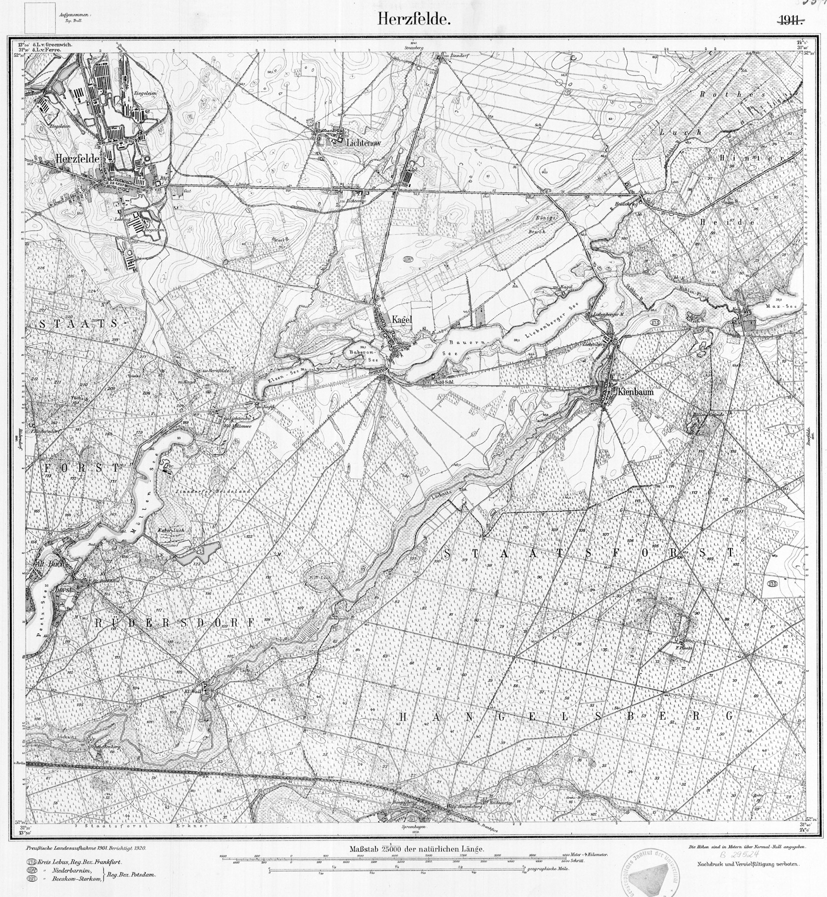
- ↑ The Rote Luch in the DTK 50: to the northeast the Stöbber, to the southwest the Stöbberbach, which flows into the Löcknitz
- ↑ Measurement table Herzfelde from 1920: Stöbber-B. ( Memento from May 11, 2013 in the Internet Archive )
- ↑ Reinhard E. Fischer : The place names of the states of Brandenburg and Berlin , Volume 13 of the Brandenburg Historical Studies on behalf of the Brandenburg Historical Commission, be.bra Wissenschaft verlag, Berlin-Brandenburg 2005.4 ISBN 3-937233-30-X , p. 16, ISSN 1860-2436 . Until 1801, Julianenhof (district of Märkische Höhe ; former Vorwerk von Reichenberg ) was called after the river Stobberow .
- ^ Dierk Heerwagen: Out and about in the Märkische Schweiz Nature Park. ... p. 46.
- ^ Fridericus (also: Friedrich) Plettner: The brown coal formation in the Mark Brandenburg . In: Journal of the German Geological Society 4, Verlag Wilhelm Ludwig Hertz (Bessersche Buchhandlung), Berlin 1852, pp. 249–483, here p. 391 at google-books .
- ↑ Eva Driescher: The Löcknitz and their catchment area ... , p. 9.
- ↑ Eva Driescher: The Löcknitz and their catchment area ... , p. 12.
- ↑ With the exception of the entries by Borgstede and the Urmes table sheet, the mentions come from certificates or documents contained in volumes XII and XX of the Codex diplomaticus Brandenburgensis . All information from: Brandenburg name book. Part 10. The names of the waters of Brandenburg . Founded by Gerhard Schlimpert, edited by Reinhard E. Fischer. Edited by K. Gutschmidt, H. Schmidt, T. Witkowski. Berlin contributions to name research on behalf of the Humanities Center for History and Culture of East Central Europe. V. Verlag Hermann Böhlaus Successor, Weimar 1996, ISBN 3-7400-1001-0 , p. 276
- ↑ On-site information board from 2004
- ^ Eva Driescher: Settlement history and anthropogenic changes in the waters in the catchment area of the Löcknitz. ( Memento from May 8, 2014 in the Internet Archive ) (PDF; 4.5 MB) In: Gewässerökologie Norddeutschlands. Issue 3, 1996
- ↑ Brandenburg name book. Part 10. The names of the waters of Brandenburg . Founded by Gerhard Schlimpert, edited by Reinhard E. Fischer. Edited by K. Gutschmidt, H. Schmidt, T. Witkowski. Berlin contributions to name research on behalf of the Humanities Center for History and Culture of East Central Europe. V. Verlag Hermann Böhlaus Successor, Weimar 1996, ISBN 3-7400-1001-0 , pp. 145f