Frechen opencast mine
| Frechen opencast mine | |||
|---|---|---|---|
| General information about the mine | |||
| Mining technology | Open pit | ||
| Information about the mining company | |||
| Operating company | Rhine brown | ||
| Start of operation | 1951 | ||
| End of operation | 1986 | ||
| Successor use | Backfilled until 2003, since agriculture and recreation area | ||
| Funded raw materials | |||
| Degradation of | Brown coal | ||
| Geographical location | |||
| Coordinates | 50 ° 53 '12.5 " N , 6 ° 44' 2.8" E | ||
|
|||
| Location | Cheeky | ||
| local community | Cheeky | ||
| District ( NUTS3 ) | Rhein-Erft district | ||
| country | State of North Rhine-Westphalia | ||
| Country | Germany | ||
| District | Rhenish lignite district | ||
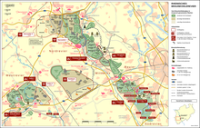
The Frechen opencast mine is a former lignite - opencast between Frechen and Kerpen . The central open-cast mine in the northern Ville (Mittleres Revier) , opened around 1949, was the first large-scale opencast mine in the Rhenish Revier . Today the area has been recultivated .
business
The Frechen opencast mine was created as a merger and expansion of several, smaller mining fields in which various companies had been mining lignite for use in briquette factories since the end of the 19th century . After several decades, these fields were charred and new deposits had to be developed, but they were located at greater depths.
After the Second World War, the dredging work was continued under the direction of the Rheinische AG for lignite mining and briquette production (later Rheinbraun ) in the new, large central open-cast mine in Frechen . From 1952, the open-cast mine began to extract coal and supply fuel to the nearby lignite power plants and briquette factories (e.g. Wachtberg briquette factory and Briquette Carl Briquette factory in Frechen) via a rail connection to the Cologne-Frechen-Benzelrath railway and the north-south railway .
At the time of its greatest expansion, the open pit had a size of about 1150 ha and a depth of about 250 m. The seam is about 40–50 m thick and slopes down to the west. A total of around 334 million tons of brown coal were mined, for which around 2.5 times the amount of overburden had to be removed (a favorable ratio for today's conditions).
In the course of the operating time, some villages were partially or completely excavated. Around 7,000 residents therefore had to be relocated.
- Bottenbroich (relocated in 1949) with Bottenbroich Abbey (excavated around 1951)
- Kerpen- Boisdorf (dredged in 1975)
- Kerpen- Mödrath (resettled 1956)
- Frechen- Habbelrath (1960–1970 partially excavated)
- Frechen- Grefrath (1952–1965 partially relocated)
- Kerpen- Balkhausen
Successor use
After the carbonization was completed, the opencast mine was backfilled and recultivated with gravel and excavated material from the neighboring opencast mines Garzweiler and Hambach (again brought in by rail) until 2003 . The site is now partly used for agricultural purposes , partly as an industrial area ( Türnich I) and partly for local recreation. On the slope at the edge of the pit near Grefrath, a vineyard of around 900 m² and over 300 vines was even built, which can produce up to 600 bottles. The Boisdorf lake (24 m deep, 17 ha large, volume about 1.5 million m³) was created in a hollow in the terrain ; In addition, a large area is used by the Erft Association as a flood retention basin for the Erft .
The open-cast mine site received wide public attention through the Marienfeld , which was held on World Youth Day 2005 especially for a large church service with Pope Benedict XVI. was created there.
Individual evidence
- ↑ Wisoveg - economic, social and traffic in the Rhineland
- ↑ RWE brochure: Destination Marienfeld (PDF)
- ↑ Kölner Stadt-Anzeiger of October 21, 2013, p. 7
- ↑ Kölner Stadtanzeiger: The new lake is full to the brim
- ↑ Technical flood protection on erftverband.de


