Skull (Haardt)
| Skull | |||
|---|---|---|---|
|
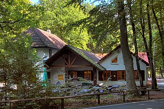
The Totenkopfhütte on the mountain saddle on Totenkopfstrasse |
|||
| Compass direction | northwest | Southeast | |
| Pass height | 513.7 m above sea level NHN | ||
| region | Bad Dürkheim district | Southern Wine Route district | |
| Valley locations | Breitenstein | St. Martin | |
| expansion | State road 514 | ||
| Mountains | Haardt (Palatinate Forest) | ||
| particularities | Excursion route Totenkopfstraße | ||
| profile | |||
| Ø pitch | 4.7% (318.7 m / 6.8 km) | 4.5% (303.7 m / 6.8 km) | |
| Map (Rhineland-Palatinate) | |||
|
|
|||
| Coordinates | 49 ° 19 '18 " N , 8 ° 2' 57" E | ||
The skull in the southern part of the Haardt mountain range on the eastern edge of the Palatinate Forest in Rhineland-Palatinate is 513.7 m above sea level. NHN situated mountain pass , via the west to east the skull road ( National Road 514) leads, and at whose pass skull hut is.
geography
The mountain saddle lies on the forest markings of Maikammer between the Rotsohlberg ( 607.1 m ) in the south-southeast and the Oberscheid ( 582.3 m ) in the northeast. 2.5 km to the east rises the 672.6 m high Kalmit , the highest mountain in the Haardt and the entire Palatinate Forest.
The 13.6 km long Totenkopfstrasse leads over the Totenkopf and connects the hamlet of Breitenstein in the northwest with the local community of St. Martin in the southeast. The top of the pass is in the middle of the route. 1.5 km east of the Totenkopf, the Totenkopfstraße crosses another mountain pass, the Hüttenhohl ( 476.9 m ). There the Landesstraße 515 joins from Maikammer in the east.
history
The name Totenkopf indicates that a skull was found there in an earlier discovered barrow on the edge of a Roman road . The Roman road once connected Spira, the forerunner of today's Palatinate city of Speyer , with Metz , later in Lorraine , which was called Divodurum Mediomatricorum in Roman times . In the area of the pass, the road embankment has been partially preserved and marked with the knight stone 246.
In the early 1960s, Bernhard Kimmel and the gang of juvenile criminals named after him committed numerous crimes in the area around the skull , which eventually culminated in a murder at the not far away Hellerhütte .
Tourism and hiking
The Totenkopfstraße is a popular excursion route . At the top of the pass is the Totenkopfhütte, a refuge of the Palatinate Forest Association (PWV) with 180 seats inside. It was taken over in 1966 by the PWV local group Maikammer, which has been managing it since then. The brick building ensemble consists of a two-story main building with two one-and-a-half-story extensions.
There are two parking spaces for hikers at the hut . Some of the hiking trails in the Palatinate Forest cross at the Totenkopf , so that the path spider can serve as a starting point for hikes in different directions.
|
|
|
|
|
|

|
|
|
|
Web links
- Location of the skull on the topographic map of the landscape information system of the Rhineland-Palatinate nature conservation administration
Individual evidence
- ↑ LANIS: mountain pass with hikers' car park. Retrieved January 23, 2017 (topographic map).
- ↑ LANIS: Place on Totenkopfstraße (L 514) near the pass. Retrieved January 23, 2017 (topographic map).
- ↑ Walter Eitel man: Ritterstein in the Palatinate Forest . Neustadt an der Weinstrasse 1998, p. 208 .
- ↑ Totenkopfhütte, 511 m. www.outdooractive.com, accessed October 1, 2018 .


