Uchiura Bay
| Uchiura Bay 内 浦 湾 |
||
|---|---|---|
|
Uchiura Bay near Yakumo with a view to the southeast of the Hokkaidō Komagatake |
||
| Waters | Pacific | |
| Land mass | Oshima Peninsula , Hokkaidō | |
| Geographical location | 42 ° 20 ′ N , 140 ° 35 ′ E | |
|
|
||
| broad | 30.2 km | |
| surface | 2 485 km² | |
| Greatest water depth | 107 m (mouth: 93 m) | |
| Tributaries | Torisaki , Otoshibe , Nodaoi , Yūrappu , Kunnui , Oshamanbe , Nukkibetsu , Osaru | |
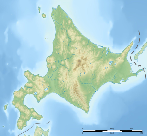
The Uchiura Bay ( Japanese 内浦湾 Uchiura-wan ) is a large circular bay , in the Oshima Peninsula of Hokkaido is. The bay is also called Funka Bay (噴火 湾 Funka-wan , "volcanic eruption bay ") because of the many active volcanoes in its vicinity .
geography

The Uchiura Bay has an area of 2485 km². The maximum water depth is 107 m in total and 93 m at the mouth of the bay. On the northeast edge of the bay is the Cape CHIKIU and in the southeast the Suna-headland at forming Stratovolcano Hokkaido-Komagatake ( 1,131 m 30.2) the limit, the opening between is approx. Km wide. Other volcanoes located on the bay are Usu ( 733 m ) , which last erupted in 2000 in the north of the bay, and the Shōwashin-zan lava dome ( 398 m ) in the northeast, one of the youngest mountains in Japan, which was not formed until 1943 to 1945 . From the bay, the Yōtei volcano ( 1898 m ) is also visible to the north .
The coastal towns of Sawara , Mori , Yakumo , Oshamanbe , Ōkishi , Toyoura , Tōya , Usu , Nagawa , Date , Mareppu , Kogane and the city of Muroran on the Etomo peninsula are located on the bay from southeast to north .
Tributaries of Uchiura Bay are, again from south to north, among others. the Torisaki at Mori, the Otoshibe and Nodaoi , the Yūrappu at Yakumo, the Kunnui , the Oshamanbe at the place of the same name, the Nukkibetsu and the Osaru at Date.
Most of the bottom sediment in the bay, with the exception of the estuary, is silty , while gravel is found in the northern part of the bay in front of Muroran. The deep water becomes low in oxygen from summer to autumn, which has an impact on the environment and fisheries along the bay.
fauna
The fish fauna consists of species such as Sargassofischen , boxfish , Embiotoca jacksoni , Sardinops melanostictus and Girella punctata . The northern part of the bay, where the waves are calmer and forage is abundant, is a wintering area for brent geese . Dolphins migrate to the bay from spring through fall, and the chances of encountering other marine mammals such as minke whales , killer whales and fur seals are also high, making whale watching in the bay popular.
The Ainu -Folklore to live a giant octopus - God called " At-kor-kamuy " can swallow in the Uchiura Bay, the whole ships and whales.
story
The coast of the Uchiura Bay was already 4000 BC. Settled by the people of the Jōmon period . Settlements have been found along its coastline that served as trading ports with other Jōmon settlements in the north of Tōhoku . In recent history, the bay was mapped during the voyage of the Royal Navy Captain William Robert Broughton and the crew of HMS Providence in the late 18th century during the eruption of nearby Usu. Because of the volcanic activity, they called the bay in September 1796 "Volcano Bay". Captain Broughton and his crew encountered Ainu and Japanese who lived in the bay while exploring the bay's coastline. At dinner they exchanged cards with the Japanese and could converse with them in Russian.
business
The bay benefits from the warm Tsushima current , so agriculture and fishing are core industries in the region. Scallops , scallops ( Mizuhopecten yessoensis ) and other aquacultures are cultivated in the bay . Trough clams ( Pseudocardium sachalinense ) make up about 17% of the total catch in Hokkaidō, in addition to which mainly Pacific pollack and plaice are caught. The industry in Muroran focuses on the raw material industries (petroleum refining, paper, steel, etc.) as well as the assembly of transportation machinery.
traffic
The southernmost section of the Muroran main line runs along the Bay of Oshamambe via the city of Date to Higashi-Muroran . From there a branch leads to the Etomo peninsula to Muroran .
gallery
View of the Yotei from Muroran Harbor, May 2013
Web links
Individual evidence
- ↑ a b c d e f g 噴火 湾 (Hunka Wan). (PDF 371 kB) International Center for the Environmental Management of Enclosed Coastal Seas, accessed on July 21, 2021 (Japanese).
- ↑ Akkorokamui. Yokai.com, accessed July 22, 2021 .
- ↑ a b William Robert Broughton: A voyage of discovery to the north Pacific Ocean: in which the coastal Asia, ... Japan ... as well as the coast of Corea have been examined and surveyed, performed in His Majesty's Sloop Providence and her tender in the years 1795, 1796, 1797, 1798 . Ed .: T. Cadell and W. Davies. 1804, p. 96-114 ( harvard.edu [accessed July 21, 2021]).
- ↑ 内 浦 湾 沿岸 の 縄 文 文化 遺跡 群. Retrieved July 21, 2021 (Japanese).


