
Utzenstorf
| Utzenstorf | |
|---|---|
 |
|
| State : |
|
| Canton : |
|
| Administrative district : | Emmental |
| BFS no. : | 0552 |
| Postal code : | 3427 |
| Coordinates : | 608 999 / 219 558 |
| Height : | 476 m above sea level M. |
| Height range : | 460–501 m above sea level M. |
| Area : | 16.94 km² |
| Residents: | 4333 (December 31, 2018) |
| Population density : | 256 inhabitants per km² |
| Mayor : | Beat Singer ( SVP ) |
| Website: | www.utzenstorf.ch |
 Landshut Castle |
|
| Location of the municipality | |
  |
|
Utzenstorf is a municipality in the Emmental administrative district in the canton of Bern in Switzerland .
geography
Utzenstorf lies at 476 m above sea level. M. , 9 km south of the city of Solothurn (linear distance). The village extends in the flat alluvial plain of the Emme , east of the canalised river course, in the Swiss Plateau .
The area of the 19.0 km² municipal area covers a section of the central Bernese plateau. Despite its size, the area is almost completely flat; the fertile and agriculturally intensively used and on average 5 km wide alluvial plain of the Emme rises slightly towards the south. The canalised and straightened Emme forms the municipality boundary in the west and south and is accompanied by a narrow forest belt. To the east, the municipality extends over a wide agricultural zone into an extensive forest area with the Burgerwald , Neu-Ischlag and Oberholz . To the east of this forest are the traffic routes of the A1 autobahn and the new Bern-Olten line built as part of Bahn 2000 , along which the border runs in parts. Only a small area with the Chölfeld , the Lindenrain ( 494 m above sea level ) and the Loonwald lies east of these traffic axes . The highest point of Utzenstorf is 498 m above sea level. M. on the banks of the Emme in the extreme south of the municipal ban. In 1997, 10% of the municipal area was in settlements, 28% in forests and woodlands, 61% in agriculture and a little less than 1% was unproductive land.
Utzenstorf includes the districts of Landshut ( 472 m above sea level ), Schachen ( 474 m above sea level ) and Ey ( 478 m above sea level ) on the western edge of the village, the hamlet of Altwiden ( 485 m above sea level ) in Altwidenfeld south of the village and numerous individual farms. Neighboring communities of Utzenstorf are Koppigen , Ersigen , Kirchberg , Aefligen , Bätterkinden , Wiler bei Utzenstorf and Zielebach .
population
With 4,333 inhabitants (as of December 31, 2018), Utzenstorf is one of the larger municipalities in the canton of Bern. 95.5% of the residents speak German, 0.7% speak Albanian and 0.7% speak Italian (as of 2000). The population of Utzenstorf was 1651 inhabitants in 1850 (at that time the largest municipality in the district), in 1900 it was 1843 inhabitants. The population increased steadily over the course of the 20th century, with the greatest growth rates being recorded during the 1960s. In 1970 3191 inhabitants were counted.
politics
The voting shares of the parties in the 2019 National Council election were: SVP 37.6%, SP 16.3%, BDP 12.4%, FDP 6.2%, GPS 10.6%, glp 9.8%, EPP 1.9 %, CVP 1.2%, pirates 1.0%.
economy

For a long time Utzenstorf was predominantly an agricultural village. A few large tree gardens around houses in the settlement area are still striking today . Today the community offers around 1900 jobs. With 6% of the workforce still employed in the primary sector, agriculture still has a minor role in the employment structure of the population. Agriculture , vegetable growing and fruit growing are predominantly practiced on the fertile soils . The forestry contributes to the income of the community. Today 116 people work in the first sector, 809 in the second sector and 971 in the third sector (as of 2014).
Mühle Beck & Cie AG belongs to the Beck family and is the oldest company in Utzenstorf. The Gautschi AG company produces sauces. Pfiffner AG manufactures rotary transfer machines and the Steffen-Ris Fenaco Cooperative is a logistics company. There are also over 100 small and medium-sized companies in the construction and transport industry, food processing, information technology, electrical industry, wood processing, horticulture and mechanical workshops.
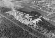
Until 2017, the Utzenstorf AG paper factory was the largest employer with 200 jobs. It had an area of 230,000 square meters. The company, founded in 1892, was closed after the takeover by Perlen Papier AG and the land was sold to the Migros Aare cooperative on February 1, 2018 . The site is to be freed from contaminated sites by 2022 . From 2024 Digitec Galaxus and the Swiss Post want to start operating on the site.
New housing estates have developed since the 1960s, especially on the eastern and southern outskirts of Utzenstorf.
traffic
The community is very well developed in terms of transport. It is located on a connecting road from Bätterkinden to Burgdorf or to Koppigen . The nearest connection to the A1 motorway (Bern-Zurich) is around 7 km from the town center. On May 26, 1875, the railway line from Burgdorf to Solothurn was put into operation with a station in Utzenstorf. A bus line takes care of the fine distribution in public transport, which serves the route from Koppigen via Utzenstorf and Bätterkinden to Messen .
history

The municipality of Utzenstorf can look back on a very long tradition of settlement. Spearheads and other remains from the Neolithic period were found on the slight elevations of Bürglenhubel, Lindenrain and Bachtelenbrünnen . A tumulus with rich grave goods (including a belt chain) dates from the Bronze Age . Only a few individual finds suggest that the area was hardly populated during Roman times .
The place was first mentioned in a document in 949 and 1009 under the name Uranestorfus . Later the names Uzonsdorf (1182), Hucenstorff (1282), Uzzestorf (1314), Utzansdorf (1329), Utzenstorf (1345) and Utzistorf (1362) appeared. The place name goes back to the Old High German personal name Uzzo or Uzzi and thus means village of Uzzo / Uzzi .
Since it was first mentioned, Utzenstorf was the center of the county of the same name (comitatus Uranestorfus), which belonged to the Kingdom of Hochburgund . In the 12th century, the Zähringers probably built a new castle, Landshut Castle, on the site of a previous Burgundian building . This later went to a Kyburg ministerial family called von Uzansdorf . Towards the end of the 14th century, Landshut and Utzenstorf were pledged to various Kyburg creditors.

In 1413 the Bernese Rudolf von Ringoltingen acquired this rule, but from then on the high level of jurisdiction lay with the Bernese Landvogtei Wangen . With the sale of the Landshut rule in 1514, the village came under direct Bernese rule. The old rulership was converted to Landshut, which in addition to Utzenstorf also included Bätterkinden, Wiler bei Utzenstorf and Zielebach. Landshut Castle served as the seat of the governor.
After the collapse of the Ancien Régime (1798), Utzenstorf belonged to the Burgdorf district during the Helvetic Republic and from 1803 to the Fraubrunnen Oberamt, which received the status of an official district with the new cantonal constitution of 1831.
During the Second World War , the cantonal government planned to build the Swiss central airport in Utzenstorf in the wide plain south of the village. However, the project failed due to popular resistance and was abandoned in 1945 in favor of Zurich Airport .
Burger families from Utzenstorf are u. a. those by Arx, Begert, Fischer, Gygli, Kehrli , Kummer, Kummli and Steiner.
Attractions

- Landshut Castle , the only moated castle in the canton of Bern, is located in a large landscaped park on the northern outskirts .
- The Reformed Church of St. Martin in the late Gothic style dates from 1522. This church was rebuilt from 1457 on the site of several previous buildings, including some older parts, including the front tower. It contains valuable coats of arms from the early Renaissance period .
- The rectory in which Jeremias Gotthelf spent his youth was built in 1727.
- In the center of the village there are numerous characteristic farmhouses with hipped roofs and granaries (a granary still thatched) from the 17th to 19th centuries.
Others
In 1928 a stone meteorite weighing 3.42 kilograms fell near Utzenstorf and was classified as an H5 chondrite . According to an eyewitness report, the stone fell to the ground near a tannery with popping noises and light phenomena.
Personalities
- Jakob Steiner (1796–1863), mathematician
- Jeremias Gotthelf (1797–1854), writer. He spent a large part of his youth and vicar time in Utzenstorf
literature
- Christian Lerch: Utzenstorf. Pictures from his past. With a report by Parish Vicar Albert Bitzius from 1824. Bern 1955.
Individual evidence
- ↑ Permanent resident population from STAT-TAB of the BfS , municipalities see also regional portraits 2020 on bfs.admin.ch, accessed on May 29, 2020
- ↑ a b Facts and Figures - Utzenstorf municipality. Retrieved May 21, 2018 .
- ↑ Results of the Utzenstorf community. State Chancellery of the Canton of Bern, October 20, 2019, accessed on August 3, 2020 .
- ↑ Mill Landshut: History. Retrieved May 21, 2018 .
- ↑ Hanspeter Flückiger: Gautschi needs more space . In: Berner Zeitung . July 29, 2014, ISSN 1424-1021 ( bernerzeitung.ch [accessed on May 21, 2018]).
- ↑ «The location is not endangered» . In: Berner Zeitung . June 16, 2015, ISSN 1424-1021 ( bernerzeitung.ch [accessed on May 21, 2018]).
- ↑ fenaco regional products - Home. Retrieved May 21, 2018 .
- ↑ Utzenstorf paper mill is closed - "This is a hard blow for the whole region" . In: az Solothurn newspaper . ( solothurnerzeitung.ch [accessed on May 21, 2018]).
- ↑ Migros buys Utzenstorf paper factory In: derbund.ch , February 1, 2018, accessed on February 1, 2018.
- ↑ Digitec Galaxus and Post want to team up in Utzenstorf. In: moneycab.com. January 29, 2020, accessed January 29, 2020 .
- ↑ Gundi Klemm: Migros apologizes for not providing information and informs the local council about plans for the paper mill area. In: solothurnerzeitung.ch. February 21, 2020, accessed February 24, 2020 .
- ↑ Armand Baeriswyl: The Utzenstorf Church, formerly St. Martin. (= Swiss Art Guide. No. 748, Series 75). Ed. Society for Swiss Art History GSK. Bern 2004, ISBN 3-85782-748-3 .
- ↑ Utzenstorf. Meteoritical Bulletin, accessed June 30, 2020 .
- ^ Eduard Gerber: About the meteor stone from Utzenstorf. (PDF) In: Yearbook of the Oberaargau. Yearbook Association Oberaargau, 1982, pp. 259–264 , accessed on June 30, 2020 .
Web links
- Official website of the Utzenstorf community
- Anne-Marie Dubler : Landshut. In: Historical Lexicon of Switzerland .
- Anne-Marie Dubler: Utzenstorf. In: Historical Lexicon of Switzerland .
Aefligen | Affoltern im Emmental | Alchenstorf | Bätterkinden | Burgdorf | Dürrenroth | Eggiwil | Ersigen | Hasle near Burgdorf | Heimiswil | Hellsau | Hindelbank | Höchstetten | Kernenried | Kirchberg | Koppigen | Krauchthal | Langnau im Emmental | Lauperswil | Lützelflüh | Lyssach | Mötschwil | Oberburg | Röthenbach im Emmental | Rüderswil | Rüdtligen-Alchenflüh | Rüegsau | Rumendingen | Rüti near Lyssach | Schangnau | Signau | Sumiswald | Trachselwald | Trub | Trubschachen | Utzenstorf | Wiler near Utzenstorf | Willadingen | Wynigen | Zielebach
Former parishes: Bärau | Bickigen-Schwanden | Crusher houses | Niederösch | Oberösch | Wil at Koppigen
Canton of Bern | Administrative districts of the canton of Bern | Municipalities of the Canton of Bern