
Vettweiß
| coat of arms | Germany map | |
|---|---|---|

|
Coordinates: 50 ° 44 ' N , 6 ° 36' E |
|
| Basic data | ||
| State : | North Rhine-Westphalia | |
| Administrative region : | Cologne | |
| Circle : | Düren | |
| Height : | 158 m above sea level NHN | |
| Area : | 83.15 km 2 | |
| Residents: | 9397 (Dec. 31, 2019) | |
| Population density : | 113 inhabitants per km 2 | |
| Postal code : | 52391 | |
| Primaries : | 02424, 02425, 02252 | |
| License plate : | DN, JÜL, MON, SLE | |
| Community key : | 05 3 58 060 | |
| Address of the municipal administration: |
Gereonstrasse 14 52391 Vettweiß |
|
| Website : | ||
| Mayor : | Joachim Kunth ( CDU ) | |
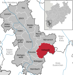
| Location of the municipality of Vettweiß in the Düren district | ||
  |
||

Vettweiß is a municipality in North Rhine-Westphalia and belongs to the Düren district .
geography
The municipality of Vettweiß is located in the southeast of the district of Düren and borders with a small piece on the Rhein-Erft district with the city of Erftstadt and on the district of Euskirchen with the city of Zülpich in the east, in the southwest and west on the communities of Nideggen and Kreuzau , im North to the municipality of Nörvenich .
Vettweiß is located in the Zülpicher Börde and borders on the northern Eifel . Right through the town flowing Neffelbach that a conservation area surrounded on both banks.
The highest point in the community is at the Ginnick water tower at 231 m above sea level. NHN , the deepest on the Neffelbach near Gladbach at 120 m above sea level. NHN . Its north-south extension is 11 km, in east-west direction 12.8 km.
In the west lies the Drover Heide , which is still largely in the Vettweiß municipality . This has been part of the Hohes Venn-Eifel Nature Park since 2020
Community structure
The municipality of Vettweiß consists of eleven districts
- Vettweiß with Kettenheim
- Froitzheim with Frangenheim
- Ginnick
- He shall
- Jakobwüllesheim
- Kelz
- Lüxheim
- Gladbach with Mersheim
- Müddersheim
- Disternich
- Sievernich
Reorganizations
On October 1, 1932, the mayor offices of Froitzheim, Kelz, Sievernich and Füssenich were merged to form the mayor's office in Vettweiß. Jakobwüllesheim and Soller were added from the Drove mayor's office . At the same time, Kettenheim was incorporated into Vettweiß. In 1947 Juntersdorf was added to the current office of Vettweiß.
On July 1, 1969, the three communities of Vettweiß, Müddersheim and Füssenich emerged from the 13 locations. Geich joins the office in Füssenich . On January 1, 1972, the municipality of Füssenich was incorporated into the city of Zülpich. The municipality of Vettweiß was enlarged to include the municipality of Müddersheim. The actual place Vettweiß had a total of 2749 inhabitants on June 30, 2020.
politics
Municipal council
The 28 seats of the municipal council are distributed among:
(As of: local elections on May 25, 2014 )
mayor
In September 2015 Joachim Kunth was elected mayor with 52.9% of the vote.
Coat of arms and banner

Coat of arms of the municipality of Vettweiß

Banner of the municipality of Vettweiß
The municipality of Vettweiß was granted the right to use a coat of arms, a banner and a seal with a certificate from the Minister of the Interior of North Rhine-Westphalia dated May 24, 1967.
Blazon : "In green a golden (yellow) shield with a black lion, growing above it a blue clad Mother of God with child in a golden (yellow) halo." The coat of arms shows the Jülich lion (Duchy of Jülich) in the small shield and the mother of God the child, patron saint of the place. The coat of arms is modeled on an aldermen's seal from 1550.
Description of the banner: "Green with the content of the municipal coat of arms in the upper third."
history
The area was settled as early as 3000 BC. Then the Celts , the Romans and later the Franks settled here .
Vettweiß is first mentioned in a probably forged document from 989, in which Archbishop Everger donated the church in Wisse to the monastery Groß St. Martin in Cologne. Around 1215 knight Otto von Wyss lived in a castle in the middle of the village .
The place name originated from "vihsse" (village, patch, soft picture ) and the preceding word "Veseuniahenis". Veseuniahenis, shortened to Vett , was the matron goddess of the village, of whom five consecration stones were found in the area.
Culture and sights
There are around 110 listed buildings in the agricultural community . Old four-sided courtyards, brick buildings and half-timbered houses , but also the castles are buildings worth seeing. The old watermills on the Neffelbach are no longer in operation today.
A Hemmoorer bucket was found on the Matronenstein near Vettweiß .
Worth seeing are:
- Antonius Chapel (Müddersheim)
- Petronella Chapel Dirlau
- Gladbach Castle
- Müddersheim Castle
- Hallenburg Disternich
- Sievernich Castle
- Trinity Chapel (Vettweiß)
- Trinity Chapel (Jakobwüllesheim)
Jewish cemeteries
There are several old Jewish cemeteries in the community:
- Jewish cemetery (Gladbach)
- Jewish cemetery (Lüxheim)
- Jewish cemetery (Kelz)
- Jewish cemetery (Kettenheim)
There is also an old cemetery between Vettweiß and Jakobwüllesheim, which was created before the Second World War.
Economy and Infrastructure
traffic
The community has a well-developed road network. The B 56 and B 477 run through the municipality . Easily accessible by the A 1 at Zuelpich and A 61 at Erftstadt . The Düren – Euskirchen railway crosses the community from north to south . Trains run on the RB 28 “Eifel-Bördebahn” line. The operator of regular freight traffic from Düren to Zülpich is the Rurtalbahn , passenger traffic to Euskirchen on weekends is operated by a citizens' initiative with vehicles from the Rurtalbahn. The reception building of the Vettweiß train station is privately owned. The Eifel-Bördebahn currently runs four pairs of trains every three hours on Saturdays, Sundays and public holidays between Euskirchen and Düren. An expansion to daily local rail transport is planned from December 2020 .
education
There are two primary schools in the community, one each in Vettweiß and Kelz. The secondary school was located in the central town until 2018. There are secondary schools in Düren, Kreuzau, Erftstadt and Zülpich. They can be reached by public transport .
There are kindergartens in Vettweiß, Froitzheim, Gladbach, Disternich, Kelz and Jakobwüllesheim.
Telephone prefixes
Vettweiß has the area code 02424. Deviating from this, the 02425 in Ginnick and the 02252 in Disternich and Sievernich apply.
Personalities
- Franz Jakob Scheuffgen (1842–1907), Provost of Trier
- Henning John von Freyend (* 1941), visual artist, lives in Sievernich
- Linda Pfeiffer (* 1948), writer, lives in Sievernich
- Sandra Lück (* 1974), Federal Chairwoman of the Animal Welfare Party, has lived in the village since March 2018.
- Martin Rehmann (* 1983), German chef, grew up in Jakobwüllesheim
- Frank Fussbroich, the son from the documentary series Die Fussbroichs , lives in Vettweiß.
Others
- In all districts there are fire fighting groups of the Vettweiß volunteer fire brigade .
Individual evidence
- ↑ Population of the municipalities of North Rhine-Westphalia on December 31, 2019 - update of the population based on the census of May 9, 2011. State Office for Information and Technology North Rhine-Westphalia (IT.NRW), accessed on June 17, 2020 . ( Help on this )
- ↑ The North Eifel Nature Park now extends into the Börde. In: Aachener Zeitung . January 13, 2020, accessed January 25, 2020 .
- ↑ Address book district Düren 1954, chap. Office Vettweiß
- ↑ Martin Bünermann: The communities of the first reorganization program in North Rhine-Westphalia . Deutscher Gemeindeverlag, Cologne 1970, p. 97 f .
- ↑ Martin Bünermann, Heinz Köstering: The communities and districts after the municipal territorial reform in North Rhine-Westphalia . Deutscher Gemeindeverlag, Cologne 1975, ISBN 3-555-30092-X .
- ↑ http://wahlen.kdvz-frechen.de/kdvz/kwew2014/05358060/index.htm
- ↑ Main statute of the municipality of Vettweiß, § 2. (PDF; 38 kB) Retrieved on December 23, 2012 .
- ^ Finding aid for the Cologne City Archives
- ↑ Regional train 28 Bördebahn between Euskirchen and Düren should soon run daily , Kölner Stadtanzeiger from January 13, 2018, accessed on August 8, 2018
Web links
Aldenhoven | Düren | Heimbach | Huertgenwald | Inden | Jülich | Kreuzau | Langerwehe | Linnich | Merzenich | Nideggen | Niederzier | Nörvenich | Titz | Vettweiß
Disternich | Froitzheim with Frangenheim | Ginnick | Gladbach with Mersheim | Jakobwüllesheim | Kelz | Lüxheim | Müddersheim | Sievernich | Soller | Vettweiß with Kettenheim