
Via Claudia Augusta (bike path)
| Via Claudia Augusta | |
|---|---|

|
|
| overall length | approx. 700 km |
| location |
|
| Starting point | Donauwörth |
| Target point | Ostiglia or Venice |
| Places along the way | Donauwörth , Augsburg , Landeck , Meran , Trient , Verona , Ostiglia ; Venice |
| Flooring | mostly asphalt or gravel bike paths |
| Height difference |
Donauwörth : 406 meters above sea level M. Fernpass : 1216 m above sea level M. Imst : 827 meters above sea level M. Reschenpass : 1507 m above sea level. M. Quarto d'Altino : 1 m above sea level M. |
| difficulty | medium |
| Traffic volume | mostly separate bike path |
| Connection to |
Danube Cycle Path , D-Route 6 , EV6 , Via Danubia , Allgäu Cycle Path , Lake Constance-Königssee Cycle Path , Inn Cycle Path , Etsch Cycle Path , Eisack Valley Cycle Route |
| ADFC certification | 4 out of 5 stars |
| Website URL | viaclaudia.org |
The Via Claudia Augusta is a 700 km long long- distance cycle path that leads from Donauwörth in Bavaria over the Alps to Ostiglia on the Po in Italy or, alternatively, to Quarto d'Altino near Venice on the Adriatic Sea . At the same time, the path allows you to cross the Alps by bike . According to the 2013 ADFC bicycle travel analysis, the Via Claudia Augusta is the most popular foreign long-distance cycle route after the Danube Cycle Path .
Basis: an ancient Roman road
The route is largely based on the course of the historic Via Claudia Augusta , a Roman road that the Roman Emperor Augustus had built from around 15 BC.
Cultural and touristic idea
In the mid-1990s, the Via Claudia was rediscovered and revitalized in a cross-border touristic and cultural collaboration. The route is primarily intended for culturally interested tourists: cycling on old tracks and flanked by historical evidence of Roman antiquity , that was the common and transnational basic idea.
Museums
Various museums invite you to learn more about history and give you a feel for historical travel and Roman geography.
These include:
- the Archaeological Museum in the dance house of Donauwörth with its Roman touring car
- the Roman Museum Augsburg with exhibits on the Via Claudia Augusta and the Roman settlement Augusta Vindelicorum
- the Fließ Archaeological Museum , which mainly represents today's Austrian section
- the South Tyrol Archaeological Museum of Bolzano informed about the Romans in the Alps of South Tyrol.
Not located directly on Via Claudia Augusta, but is equipped with informative exhibits:
- the Tyrolean State Museum in Innsbruck
- the Museo Lapidario Maffeiano in Verona . It presents the ancient Roman culture very comprehensively.
Historical route along Roman and medieval passages
In contrast to the modern, paved road, the cycle path often follows the old Roman route. The graveled Fernpass crossing, for example, which is located off the busy Fernpass road, mainly follows the old paths of the Roman Via Claudia Augusta, if this path can be reconstructed. So far, it has not been possible to do this in detail in all places without any doubt, even if the basic direction is not disputed.
Characteristic

The Via Claudia Augusta is considered to be the easiest alpine crossing in Europe for cyclists. This makes it a frequently used one.
In terms of the direction of travel, the vast majority only consider the tour from north to south. In the opposite direction there are considerably more steep and also very long climbs, for example if you look at the Adige Valley.
In terms of landscape, the Via Claudia Augusta is extremely varied:
Bavaria: from the Danube to Ostallgäu
Between Donauwörth in the Danube Valley and Landsberg, the wide and comparatively flat Lech Valley characterizes the journey. South of Landsberg you can experience the foothills of the Alps with its hills and alpine pastures.
North Tyrol
From Füssen, the high mountains finally begin in the Ausserfern, with some more challenging routes through rocky landscapes. The first passes ( Kniepass , Ehrenberger Klause and Fernpass ) lead increasingly upwards. The Inn , which accompanies the path from Imst , then appears as a mountain river, the path climbs steadily and leads shortly before the Reschenpass for a small section into the Lower Engadine . The Switzerland will leave soon.
South-Tirol
When you reach the Vinschgau , the main Alpine ridge is crossed. The first Mediterranean influence can be felt from spring to autumn. The vegetation in South Tyrol becomes more lush, extensive orchards alternate with vineyards.
Veneto and the Po Valley
With the extensive Po Plain , a flat, fertile lowland in northern Italy is reached, before the Mediterranean finally comes into view as a destination.
Cities and places along the route
A detailed list of all the important places in Bavarian, Austrian and Italian territory can be found in the route description Places on the Via Claudia Augusta .
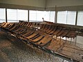
A possibly historical feeder to the Via Claudia Augusta: the remains of Roman Danube ships in the Celtic Roman Museum of Manching , around 100 AD

Epfach was an important Roman trading center. The Venus von Epfach , a figurative representation of the Roman deity of love , was found there on the Via Claudia Augusta

This section of the old Roman road is hardly passable with two-wheelers: the section was artificially flooded by the Forggensee , the new route runs on the lake shore

Time and again, today's Via Claudia Augusta leads past display boards that provide information about the historical culture of the Romans over 2000 years ago; here is an information board right on the bike path in Imst

The stone arch bridge near Serfaus leads 8 m over a rocky run. It probably dates from the Middle Ages, but the shape and construction consistently correspond to the Roman bridge construction technology.

Historical information on the bike path: the Kajetansbrücke over the Inn

The cycle path in the Inn valley shortly before the Kajetansbrücke, which is crossed under , not crossed; the route now leads for one stage into the Lower Engadine

In the border triangle just before Martina GR in Graubünden . The road can be seen on the left , there is no longer any space for your own bike path in the narrow Inn Valley

A few inns are also named after the Via Claudia Augusta, such as here in Nauders (building on the left)

The Italian section of the bike tour begins at Lake Reschen

Roman bridgehead in Lagundo

Ötzi was there long before the Romans . The South Tyrolean Archeology Museum in Bolzano represents both historical periods

The Via Claudia Augusta runs flat and straight between Bolzano and Trento, here near Auer

In the Trento area , not only the river accompanies the cycle path, but also the busy Brenner motorway and the well-frequented railway line from the Brenner Pass


Expansion and infrastructure
Markings and signage

Much of the path is well developed for cycling and has been developed for tourism, so that since it opened it has developed into a popular transalp for cyclists.
The signage of the cycle path is very different. In Bavaria, the Via Claudia Augusta cycle path is fully equipped with square signs up to the border. These are white, on them the three arcs of Via Claudia are shown, underneath is written in black on orange and below Claudia Augusta. In Austria the signage is a bit denser, but the signs there are smaller. There are also floor markings in Austria. In South Tyrol you will find the signs for the Vinschgau and Etschtal cycle paths. In the rest of Italy there are only sections of signs for the Via Claudia Augusta.
Between Augsburg and feet is now throughout the new signs for ADFC and FGSV , as part of the INTERREG implemented IIIb project. In all states, the signs and markings are sometimes missing due to vandalism or construction work.
Shuttle and shuttle service with bicycle transport


Cyclists can use the Fernpass , the Reschenpass , between Trento and the Valsugana, from Castelnuovo in the Valsugana to the Tesino valley, over the Croce D'Aune Pass and the Praderadego Pass, with shuttle buses with bike transport options.
The Via Claudia Augusta also operates a shuttle that transports cyclists from Italy along the route back to Germany. Entry points are: Quarto D'Altino near Venice, Verona, Rovereto, Trento, San Michele all'Adige near Trento, Bozen and Merano. How to book the shuttles via the passes and the shuttle from Italy to Germany can be found on the official homepage of the Via Claudia Augusta project.
alternative
The Albrecht route , a mountain bike route that crosses the Alps, takes you through high mountain regions from Garmisch-Partenkirchen to Torbole on Lake Garda in seven days . She uses revitalized sections of the Via Claudia Augusta.
See also
Literature and maps
- Bikeline bike tour book Via Claudia Augusta , 1: 75.000, Verlag Esterbauer , 8th edition 2015, ISBN 978-3-85000-627-9
- Christoph Tschaikner: Hikeline long-distance hiking trail: Via Claudia Augusta . Esterbauer, summer 2010, ISBN 978-3-85000-510-4
- Christoph Tschaikner: Kompass cycling tour book Via Claudia Augusta - cycling in the footsteps of the Romans . 2009, ISBN 978-3-85026-067-1
- Christoph Tschaikner: Kompass cycling map Via Claudia Augusta - cycling in the footsteps of the Romans . 2009, ISBN 978-3-85026-146-3
- Kay Wewior: The Via Claudia Augusta Bike Travel Book . Verlag BoD, 2008, ISBN 978-3-8370-4543-7
Web links
- http://www.viaclaudia.org/ Official website Via Claudia Augusta Bavaria - Tyrol - Italy
- http://www.alpen-radler.de/ Website for the book: information, map and tips on the bike path
- http://erlebnis-via-claudia-augusta.de/huckepack/ Luggage and bike transport on the Via Claudia Augusta
- History-Tyrol: Via Claudia Augusta
- Via Claudia Augusta from Resia to Merano
- Via Claudia Augusta Etschradroute Vinschgau
- Common homepage of the VCA associations along the cycle path
- Via Claudia Augusta in the bike travel wiki with GPS data
Individual evidence
- ↑ Via Claudia Augusta ID 5291 ( Memento from August 22, 2017 in the Internet Archive ), on adfc-tourenportal.de, accessed on August 21, 2017
- ^ The ADFC Cycle Travel Analysis 2013 - Figures, data and facts , ADFC website, accessed on February 18, 2019
- ↑ Martin Aschaber, Günter Guglberger, Karl Sporschill: Bridges in Tirol . Studienverlag, Innsbruck 2010, ISBN 978-3-7065-4957-8 , p. 82 .
- ^ Department of Monument Preservation of the State of South Tyrol (ed.): Monument Preservation in South Tyrol 2008 . Tappeiner, Bozen 2009, ISBN 978-88-7073-525-3 , chapter bridge, p. 152-153 ( PDF file ).
- ↑ MountainBIKE magazine : Alpencross Garmisch – Riva. Already a classic: The Albrecht route manages almost entirely without sliding passages . Edition June 2009. Online at www.mountainbike-magazin.de. Retrieved August 8, 2017.