
Algund
| Algund | |
|---|---|
| (Italian: Lagundo ) | |
coat of arms
 |
map  |
| State : | Italy |
| Region : | Trentino-South Tyrol |
| Province : | Bolzano - South Tyrol |
| District community : | Burgrave Office |
|
Inhabitants : (VZ 2011 / 31.12.2019) |
4,877 / 5,025 |
|
Language groups : (according to 2011 census ) |
85.17% German 14.58% Italian 0.25% Ladin |
| Coordinates | 46 ° 41 ′ N , 11 ° 7 ′ E |
| Altitude : | 302– 2600 m slm (center: 350 m slm ) |
| Surface: | 23.6 km² |
| Permanent settlement area: | 7.6 km² |
| Parliamentary groups : | Aschbach / Ried, village , forest, Mitterplars, Mühlbach, Oberplars, Vellau |
| Neighboring municipalities: | Lana , Marling , Meran , Naturns , Partschins , Plaus , Tyrol |
| Partnership with : | Etzenricht , Bavaria |
| Postal code : | 39022 |
| Area code : | 0473 |
| ISTAT number: | 021038 |
| Tax number: | 82003130216 |
| Mayor (2015): | Ulrich Gamper ( SVP ) |
Algund ([ alˈgʊnt ]; formerly in the South Tyrolean dialect Lagund ; Italian Lagundo ) is an Italian municipality with 5025 inhabitants (as of December 31, 2019) in South Tyrol . It borders directly on Merano and lies at the foot of the Texel group .
Tourism as well as fruit and wine growing are of particular economic importance . In the Forst faction is the beer brewery of the same name ( Brauerei Forst AG ), one of the largest in Italy .
The many churches and chapels, the Maria Steinach Monastery and Vorst Castle are well worth seeing .
geography

The municipality of Lagundo extends over two separate areas in the Adige Valley : a larger one in the Burggrafenamt , a smaller one in the Vinschgau . Administratively, it is the district community Burggrafenamt allocated.
The largest settlement centers are in the Burggrafenamt on the western edge of the Merano basin below the Töll . On the true left , northern side of the valley are here today Community Center Mühlbach ( 350 m ) and to a hillside at the fractions village ( 390 m ), Mitterplars ( 400 m ) and Oberplars ( 550 m ). Even further up there is a slope in the village of Vellau ( 950 m ), overlooked by the Mutspitze ( 2291 m ) and the Spronser Rötelspitze ( 2625 m ). As part of the Texel Group, these represent the southeastern foothills of the Ötztal Alps and are protected in the Texel Group Nature Park . In the valley floor on the other side of the Etsch lies the forest fraction ( 380 m ).
The territorial exclave in the Vinschgau, which belongs to the municipality of Lagundo, lies west of Partschins for the most part on the orographically right, southern side of the valley. It stretches from the valley floor with the hamlet of Ried ( 520 m ) over the slopes of the Nördersberg , where the village of Aschbach ( 1350 m ) is located. Above this, the municipality on the ridge of the Vigiljoch , which forms the northeasternmost foothills of the Ortler Alps in the Zufrittkamm , reaches an altitude of 2018 m on the Rauhen Bichl .
history
The earliest written document is from around 1000 and is "Alagumna". The name goes back to the Latin ad lacumina ('near the pond'). The field name referred to an alluvial land from the time when the Adige was not yet regulated. Until the 20th century, a farm on the edge of the village was called "Beim Lacknern".
In 1932 and 1942, four figure menhirs from the Copper Age were found in Algund , two of them are in the South Tyrolean Archaeological Museum in Bozen , the other two in the Palais Mamming Museum in Merano (see also Algunder menhirs ). Replicas are on display in front of the tourist office.
In Roman times, the Via Claudia Augusta probably ran through Algund. The bridgehead on the banks of the Etsch, which supposedly dates from this period, was roofed over with a glass structure in 2011.
Around 1241 Adelheid, daughter of Count Albert von Tirol , founded the Maria Steinach monastery .
In the course of the German Peasants' War , there was an uprising of the Tyroleans under Michael Gaismair in 1525 , whereby Algund also became a combat zone.
On July 27th, 1765 Anna Ladurner was born in Lagundo, who married the landlord Andreas Hofer on July 21st, 1789 in Merano . She died on December 6, 1836 in St. Leonhard in Passeier .
climate
Lagundo is climatically favored, in a spacious valley basin, which is framed by high mountains. To the north, the Texel Group and the Ötztal Alps shield the area from the cold polar and North Sea air; to the west, the valley is protected from damp Atlantic currents by the Ortler Alps. This favors relatively dry winters with mean temperatures above freezing point. To the south-west and south, the wide Adige Valley opens into the Po Valley near Verona and thus ensures the supply of warm Mediterranean air masses from the area of the upper Adriatic or the Gulf of Genoa. This has a particular effect on the transitional seasons of spring and autumn, when the valley basin near Lagundo, protected by high mountains, can heat up quickly.
The result is remarkable maximum temperatures in spring: In March, at 15 degrees Celsius, it is as warm as, for example, on the Cote d'Azur and warmer than on the northern Adriatic coast. In April, the maximum temperatures of 20 degrees Celsius already reach values such as in the Gulf of Naples, Sardinia or the Balearic Islands (Mallorca). At 24 degrees Celsius, May sometimes even exceeds the southern holiday regions in the Mediterranean. After temperatures around 30 degrees Celsius in June, July and August, September is also pleasantly warm with 24 degrees Celsius.
Culture and sights
_von_oben.JPG)
(New) Catholic Church of St. Joseph
Plans to build a new church matured in Lagundo as early as the 1910s, as the old church of St. Hippolyt and St. Erhard in the original town center could no longer do justice to the larger community size. The subsequent world wars and the interim Italian fascism pushed all new construction plans into the background. It was not until the 1960s that the idea of building a modern sacred building in the valley floor of the Mühlbach district was renewed. Between 1966 and 1971, the new parish church was built according to plans by architect Willi Gutweniger in the new, modern, tourist-oriented town center. Ordinary operation could finally begin in May 1971 after construction was completed. The inauguration had to wait until March 1977, however, as the organ ordered in Austria could not be purchased due to the devaluation of the lira.
The new church with its 70-meter-high, needle-shaped steeple , which is atypical for the Alpine region, has numerous symbolic features. In contrast to the traditional buildings, it is oriented to the south. In addition to the altar, two large, floor-to-ceiling glass windows extend into the visitors' area to the east and west.


What is remarkable is the church interior, which is oriented towards the width and, in contrast to the traditional longitudinal structure, allows the worshipers to move closer to the altar. The building, which is hexagonal in its basic structure, is equipped with religious symbols. The holy water stone in the entrance area rests on the five-pointed Drudenfuß , as a symbol of the pagan and aims to represent the liberation from evil through baptism.
Buildings

Remains of the alleged Algunder Roman bridge (formation in the 15th century more likely)
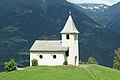
Maria Schnee chapel in Aschbach, built in 1695

New St. Joseph Church

Old parish church of St. Joseph ⊙

_Kapelle_Maria_Schnee.jpg)


Algund music band
The band was founded in 1837 and currently has over 80 active members.
Her literature includes transcriptions of classical works of opera, operettas and orchestral literature, original works for wind music by Tyrolean and international composers, waltzes, marches, polkas, film music and musicals.
traffic
Lagundo is easily accessible via the Meran-Bozen (MeBo) expressway and the country roads from Meran, Marling or Töll .
The Vinschgau Railway ( Mals - Meran ) serves the place with one stop.
Aschbach, the highest part of Algund (1360 m above sea level), can be reached via a mountain road (12 km) and the Aschbach cable car from Rabland .
The Vellau district (900 m above sea level) can be reached via a road link and a chair lift . From there a basket lift leads to the Leiteralm .
politics
mayor
Mayor since 1952:
- Johann Gamper: 1952-1995
- Anton Schrötter: 1995-2010
- Ulrich Gamper: since 2010
Community partnerships
- Etzenricht , Bavaria
literature
- Maria Kiem: 1000 years of Algund. Athesia, 2008 (online) .
- Franz-Heinz Hye : History of Algund near Meran. Edited by the municipality of Algund, 1986.
- Adelgott Schatz: The Algund parish family book . In: Der Schlern , 1922, pp. 38–43 (online) .
Web links
- Entry in the Tirol Atlas of the Institute for Geography at the University of Innsbruck
- Lagundo municipality
- Landscape plan of the municipality of Algund . Office for Landscape Ecology, Autonomous Province of Bolzano - South Tyrol (PDF file)
- History of Tyrol: Algund
Individual evidence
- ↑ Website of the municipality of Algund
- ^ Maria Kiem: 1000 years of Algund, p. 115
- ^ Christian Schneller: Contributions to the topography of Tyrol . Ed .: Branch of the Leo Society for Tyrol and Vorarlberg. Verlag der Vereinbuchhandlung, Innsbruck 1893, p. 5–6 ( digitized version [accessed on August 22, 2020]).
- ^ Department of Monument Preservation of the State of South Tyrol (ed.): Monument Preservation in South Tyrol 2008 . Tappeiner, Bozen 2009, ISBN 978-88-7073-525-3 , chapter bridge, p. 152-153 ( PDF file ).
- ↑ Algunder Musikkapelle - Die Algunder - Musikkapelle in Südtirol - Musikkapelle Algund. Retrieved April 4, 2019 .
- ↑ The mayors of the South Tyrolean municipalities since 1952. (PDF; 15 MB) In: Festschrift 50 Years of the South Tyrolean Association of Municipalities 1954–2004. Association of South Tyrolean municipalities, pp. 139–159 , accessed on November 16, 2015 .

Abbey | Ahrntal | Aldein | Algund | Altrei | Andrian | Auer | Barbian | Bolzano | Branzoll | Burner | Brixen | Brunico | Burgstall | Corvara | Nova Ponente | Enneberg | Eppan | Feldthurns | Franzensfeste | Freienfeld | Gais | Gargazon | Glurns | Graun im Vinschgau | Casies | Avelengo | Innichen | Jenesien | Kaltern | Karneid | Kastelbell-Tschars | Castelrotto | Kiens | Klausen | Kuens | Kurtatsch | Kurtinig | Lasa | Laion | Lana | Laces | Laurein | Laives | Lüsen | Times | Margreid | Marling | Martell | Merano | Mölten | Montan | Moos in Passeier | Mühlbach | Mühlwald | Nals | Naturno | Naz-Sciaves | Neumarkt | Niederdorf | Olang | Partschins | Percha | Falzes | Pfatten | Pfitsch | Plausibility | Prad | Braies | Prettau | Proveis | Lawn Antholz | Ratschings | Riffian | Ritten | Rodeneck | Salurn | Sand in Taufers | Sarntal | Schenna | Schlanders | Schluderns | Schnals | Sexten | St. Christina in Val Gardena | St. Leonhard in Passeier | St. Lorenzen | St. Martin in Passeier | St. Martin in Thurn | St. Pankraz | Ortisei in Val Gardena | Sterzing | Stilfs | Taufers im Münstertal | Terenten | Terlan | Tiers | Tyrol | Tesimo | Toblach | Tramin | Truden | Tscherms | Ulten | Our Lady in the Walde-St. Felix | Vahrn | Villandro | Villnöß | Vintl | Fiè allo Sciliar | Verano | Waidbruck | Monguelfo Tesido | Welschnofen | Wengen | Selva in Val Gardena