
Selva in Val Gardena
| Selva in Val Gardena | |
|---|---|
| (Lad .: Sëlva , Italian: Selva di Val Gardena ) | |
coat of arms
 |
map  |
| State : | Italy |
| Region : | Trentino-South Tyrol |
| Province : | Bolzano - South Tyrol |
| District community : | Salten-Schlern |
|
Inhabitants : (VZ 2011 / 31.12.2019) |
2,664 / 2,586 |
|
Language groups : (according to 2011 census ) |
5.15% German 5.11% Italian 89.74% Ladin |
| Coordinates | 46 ° 33 ' N , 11 ° 46' E |
| Altitude : | 1.400– 3179 m slm (center: 1563 m slm ) |
| Surface: | 53.27 km² |
| Permanent settlement area: | 3.1 km² |
| Parliamentary groups : | plan |
| Neighboring municipalities: | Abbey (Badia), Campitello di Fassa , Canazei , Corvara , St. Christina in Gröden , St. Martin in Thurn |
| Postal code : | 39048 |
| Area code : | 0471 |
| ISTAT number: | 021089 |
| Tax number: | 00411710213 |
| Mayor (2015): | Rolando Demetz |

Selva in Val Gardena ( Ladin , Italian Selva di Val Gardena ) is an Italian municipality with 2586 inhabitants (as of December 31, 2019) in Val Gardena (Ladin Gherdëina ) in South Tyrol . Together with St. Ulrich and St. Christina , it is one of the three municipalities in the valley in which, in addition to German and Italian , Ladin is the official language.
climate
The average maximum daily temperature in the summer months is between 18 and 21 ° C, the average night-time minimum in the winter months is −6 to −8 ° C. The average air temperature in Selva is 4.8 ° C, the annual precipitation 911.6 mm. On average, the highest amount of precipitation results in June with 135 mm, while February is the driest month with almost 21 mm. These values were measured by the weather station in Plan at 1,594 meters in the period 1991–2016.
|
Monthly average temperatures and precipitation for Selva Val Gardena (weather station Plan at 1,594 meters)
Source:
monthly values for temperatures and monthly values for precipitation . Provincial weather service of the Autonomous Province of Bolzano - South Tyrol (period 1991–2016) |
|||||||||||||||||||||||||||||||||||||||||||||||||||||||||||||||||||||||||||||||||||||||||||||||||||||||||||||||||||||||||||||||||||||||||||||||||||||||||||||||||||||
geography

The 53.27 km² large municipality of Selva in Ladinia occupies the valley head of Val Gardena and the surrounding mountain ranges of the Dolomites . The Val Gardena valley, where next to the village center (1540- 1620 m slm ) and just southeast of the Group plan (1580- 1620 m is located), is densely populated; In the west, the municipality of Selva extends to just before the center of St. Christina ( Santa Cristina ), where the lower course of the Cislesbach ( Ruf de Cisles ) , which flows into the Grödner Bach ( Derjon ), represents the municipality boundary .
To the north and northeast of the settlement areas, the community includes large parts of the Puez group , which are protected in the Puez-Geisler Nature Park . The uninhabited Vallunga ( Val ), which begins near Wolkenstein, leads north-east deep into the Puez group. To the west, the Vallunga is bounded by the Stevia ( 2555 m ) and the Col dala Pieres ( 2747 m ), the Piz Duleda ( 2909 m ), the Puez peaks (2918 and 2913 m , Pizes de Puez ) and the Puezkofel rise above the valley head ( 2725 m , Col de Puez ), two smaller side valleys branch off on its east side to the Gardenazza plateau, which carries the Lech de Crespëina ( 2380 m ). Directly to the east above Selva are the Cir peaks ( Pizes de Cir ), which represent the southern end of the Puez group and are separated from the Sella group by the Gardena Pass ( 2121 m , Jëuf de Frea ).
In the southeast of the municipality of Selva there are parts of the Sella group with a whole series of peaks - including the Piz Ciavazes ( 2828 m ) and the Sella towers - and the Lech dl Dragon ( 2680 m ). In the southwest of Selva - separated from the Sella group in the east by the Sella Pass ( 2218 m , Jëuf de Sela ) - the Langkofel group rises . The highest peaks in the municipality are located here: the Langkofel ( 3181 m , Saslonch ), the Fünffingerspitze ( 2996 m ) and the Grohmannspitze ( 3126 m ). The southern border of Selva corresponds to the provincial border with Trentino .
In terms of traffic, the municipality is primarily developed through the Grödner Straße . This leads from the Eisack valley to the west via Ortisei ( Urtijëi ) - avoiding the center of S. Cristina with the bypass road in the south - to Selva and is open all year round. In addition, the place can be reached via two pass roads, the opening of which depends on the snow conditions: In an easterly direction a road overcomes the Passo Gardena to Corvara in the South Tyrolean Gadertal ( Val Badia ), in the south the Passo Sella to Canazei ( Cianacèi ) in the Trentino Fassa Valley ( Fascia ).
politics
- South Tyrolean People's Party : 4
- Ladins Dolomites : 2
- Lista Civica Selva : 9
Mayor since 1952:
- Anton Vinatzer: 1952–1960
- Rodolfo Kasslatter: 1960–1964
- Franz Costa: 1964–1980
- Ferdinand Mussner: 1980–1985
- Hermann Senoner: 1985–1996
- Roland Demetz: 1996–2010
- Peter Mussner: 2010–2015
- Roland Demetz: since 2015
economy

The main branch of the economy, with 8,000 guest beds and around 1,000,000 overnight stays per year, is tourism , which therefore has a massive impact on the village. Winter sports are particularly important (as in the other Val Gardena communities) . Selva is one of the starting points for the Sellaronda , the ski tour around the Sella massif .
education
Selva is the seat of a school district in Ladin. This includes the elementary school and the middle school in Selva, as well as the elementary school in the neighboring municipality of St. Christina.
Attractions
- The parish church "Maria Himmelfahrt"
- The New Year's Eve chapel in Vallunga with frescoes over 300 years old about the passion of Jesus.
- Until 1960 the place was by the train of Val Gardena with Ortisei and Klausen connected. The Val Gardena Railway was mainly built by Russian prisoners of war who were used as slave labor in the First World War. Today the former route has been converted into a hiking and cycling path, numerous monuments and historical pictures along the way remind of the construction and operating times.
- The Wolkenstein castle ruins at the entrance to the Langental in the rock face.
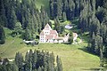
- The Fischburg

Hiking, climbing, mountaineering
In the immediate vicinity of the village, to the right of the entrance to Vallunga, behind the military school, there is a small climbing garden . Its easy routes are very well secured and enable beginners to practice safely on the rock. There are also several via ferratas and numerous hiking trails.

Sports
Selva has an ice stadium, a tennis hall, a soccer field in Plan and a cross-country ski run in Vallunga. In 1970, Val Gardena hosted the Alpine World Ski Championships , with the Dantercepies slope in Selva.
The ice hockey club HC Gherdëina plays in Selva.
Sons and daughters of Selva
- Belsy Demetz (* 1984), singer
- Emilio Comici (1901–1940), mountaineer
- Adolf Insam (* 1951), ice hockey player and coach
- Evelyn Insam (* 1994), World Cup ski jumper
- Marco Insam (* 1989), ice hockey player
- Michaela Marzola (* 1966), ski racer
- Hans Nogler (1919–2011), ski racer
- Sophie Nogler (1924–2015), ski racer
- Werner Perathoner (* 1967), ski racer
- Milena Rudiferia , singer
- Peter Runggaldier (* 1968), ski racer
- Carlo Senoner (* 1943), ski racer
- Karl Unterkircher (1970–2008), extreme mountaineer
- Alex Vinatzer , ski racer
- Sabina Willeit , singer

Fresco depicting the Lord in the New Year's Chapel

Wolkenstein castle ruins, only the valley wall remains

Wolkenstein castle ruins, the valley wall

Climbing garden near Selva at the end of the village in the direction of Vallunga
Fischburg


literature
- Rudolf Mussner: Nosta Sëlva , Cunsëi de furmazion de Sëlva, 2010. (Ladin)
Web links
- Wolkenstein municipality
- Landscape plan of the municipality of Selva di Val Gardena . Office for Landscape Ecology, Autonomous Province of Bolzano - South Tyrol (PDF file)
- Entry in the Tirol Atlas of the Institute for Geography at the University of Innsbruck
- 360 ° webcam
Individual evidence
- ↑ The mayors of the South Tyrolean municipalities since 1952. (PDF; 15 MB) In: Festschrift 50 Years of the South Tyrolean Association of Municipalities 1954–2004. Association of South Tyrolean municipalities, pp. 139–159 , accessed on November 16, 2015 .
- ↑ School district Wolkenstein. South Tyrolean Citizens' Network , accessed on October 25, 2014 .

Abbey | Ahrntal | Aldein | Algund | Altrei | Andrian | Auer | Barbian | Bolzano | Branzoll | Burner | Brixen | Brunico | Burgstall | Corvara | Nova Ponente | Enneberg | Eppan | Feldthurns | Franzensfeste | Freienfeld | Gais | Gargazon | Glurns | Graun im Vinschgau | Casies | Avelengo | Innichen | Jenesien | Kaltern | Karneid | Kastelbell-Tschars | Castelrotto | Kiens | Klausen | Kuens | Kurtatsch | Kurtinig | Lasa | Laion | Lana | Laces | Laurein | Laives | Lüsen | Times | Margreid | Marling | Martell | Merano | Mölten | Montan | Moos in Passeier | Mühlbach | Mühlwald | Nals | Naturno | Naz-Sciaves | Neumarkt | Niederdorf | Olang | Partschins | Percha | Falzes | Pfatten | Pfitsch | Plausibility | Prad | Braies | Prettau | Proveis | Lawn Antholz | Ratschings | Riffian | Ritten | Rodeneck | Salurn | Sand in Taufers | Sarntal | Schenna | Schlanders | Schluderns | Schnals | Sexten | St. Christina in Val Gardena | St. Leonhard in Passeier | St. Lorenzen | St. Martin in Passeier | St. Martin in Thurn | St. Pankraz | Ortisei in Val Gardena | Sterzing | Stilfs | Taufers im Münstertal | Terenten | Terlan | Tiers | Tyrol | Tesimo | Toblach | Tramin | Truden | Tscherms | Ulten | Our Lady in the Walde-St. Felix | Vahrn | Villandro | Villnöß | Vintl | Fiè allo Sciliar | Verano | Waidbruck | Monguelfo Tesido | Welschnofen | Wengen | Selva in Val Gardena