Laion
| Laion | |
|---|---|
| (Italian: Laion ) | |
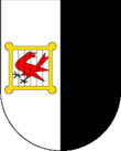
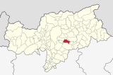
| coat of arms | map |
| State : | Italy |
| Region : | Trentino-South Tyrol |
| Province : | Bolzano - South Tyrol |
| District community : | Eisack Valley |
|
Inhabitants : (VZ 2011 / 31.12.2019) |
2,621 / 2,746 |
|
Language groups : (according to 2011 census ) |
89.93% German 3.93% Italian 6.14% Ladin |
| Coordinates | 46 ° 36 ' N , 11 ° 34' E |
| Altitude : | 464– 2282 m slm (center: 1093 m slm ) |
| Surface: | 37.3 km² |
| Permanent settlement area: | 11.4 km² |
| Parliamentary groups : | Albions, Freins, Lajen , Ried, St. Peter , Tanirz, Tschöfas |
| Neighboring municipalities: | Barbian , Castelrotto , Klausen , Ortisei in Val Gardena , Villanders , Villnöß , Waidbruck |
| Postal code : | 39040 |
| Area code : | 0471 |
| ISTAT number: | 021039 |
| Tax number: | 80007310214 |
| Mayor (2015): | Stefan Leiter ( SVP ) |
Lajen ([ laˑjən ]; Italian Laion , Ladin Laion or Laiun ) is an Italian municipality of 2,746 inhabitants (December 31, 2019) in the Isarco Valley and at the entrance of Val Gardena in South Tyrol .
geography

The municipality of Laion comprises areas in the Eisack Valley and the lower Val Gardena . It stretches over a mountain ridge characterized by forest and meadows, which represents the westernmost foothills of the Geisler group of the Dolomites . In the west the Eisack and in the south the Grödner Bach form the municipal boundary . In the north, the municipality ends just beyond the watershed on the slopes that already descend to the Villnößtal , in the east on the mountain edge of Ausserraschötz , where Lajen finds its highest point at 2282 m .
The main town of Laion is located at about 1100 m slm on a low mountain range at the transition from Val Gardena to the Eisack Valley. The farmsteads and hamlets below in locations closer to the valley are assigned to the Lajener Ried fraction (divided into Ausserried, Innerried, Oberried and Unterried). The village of Albions ( 880 m ) and the scattered settlement Freins ( 1100 m ) are located north of the main town on the east-facing, orographically left-hand slopes of the Eisack Valley . To the east of the main town, the settlements of Tschöfas ( 1200 m ), Tanirz ( 1170 m ) and St. Peter ( 1200 m ) are lined up on the north-facing, orographically right-hand slopes of the Val Gardena , to which the small town of St. Peter im Tal ( 950 m ) is located m ) heard on the Grödner Bach. The location Pontives ( 1100 m ) forms the eastern end point of the valley section that is part of Laion and marks the beginning of the Ladin Val Gardena.
history
Settlement of the Laion area can be traced back to the Stone Age (about 6,000 years BC). In fact, a hunter resting place from this time has been proven on the Raschötz (Laion's local mountain). Finds from the Bronze and Iron Ages (circa 2200 to 2005 BC) and a menhir were discovered during excavations at Wasserbühl. Due to the favorable location of Lajen, the settlement was able to develop well. The oldest references are small, typical stone tools and a massive figure menhir. This menhir was made from gneiss (granite gneiss / orthogneiss). It measures 170 centimeters in length and 160 centimeters in height and is a maximum of 40 centimeters wide. The weight of the menhir is around 1500 kg. On the menhir there is an anthropomorphic representation with shoulders, neck and head. There are also two daggers, one of which is not clearly recognizable. A Rhaetian house was found from the Iron Age. The building was built between the 5th and 3rd centuries BC. Classified. Several coins have been found from Roman times. The place name Laion (" Legian ") appears for the first time in a deed of donation from the Freising Monastery from 993 / 94-1005. In this document, a widow named Luitpirch hands over all of her property to Bishop Albuin von Brixen . The bishopric Augsburg was also well-off in Laion in the Middle Ages.
Culture & sights
Buildings
Walther von der Vogelweide
Laion is one of those places that are discussed as the birthplace and / or place of residence of Walther von der Vogelweide . The research of the Lajener pastor and later Archbishop of Salzburg, Johannes Evangelist Haller, contributed to this. For Laion, this is due to the supraregional fame of its bird pastures from the fact that the Lajener Ried, in which bird pastures can be found, is close to the landscape and connected to the village of Waidbruck . Waidbruck was a key point on the so-called Kaiserstraße until the opening of the Kuntersweg through the Eisack Gorge (around 1314). Many travelers, merchants, pilgrims and clergymen passed by here. The possessions of the Hochstift Augsburg and the Diocese of Freising in Laion also ensured a lot of mobility. Bishop Wolfger von Passau, a sponsor of Walther, has documented his passage on this route. The name Waidbruck goes back to the connection to the adjacent pastures and suggests a connection with the bird pastures from the topographical peculiarity of this area. The indication that “von der Vogelweide” can be read as a designation of origin does not exclude the Lajener Ried as Walther's place of origin and / or residence.
In Laion, hiking days and parades with the motto "Walther von der Vogelweide" are organized at irregular intervals with the active participation of local clubs and shops, most recently as the 4th hiking day ("Marcia") on July 26, 2014. In Laion there is also a Von -der-Vogelweide-Strasse.
Landscape image
The settlement area in Laion is characterized by scattered farms and hamlets. The numerous arable terraces and the surrounding woodland (trees and bushes) are among the characteristics of the cultural landscape on the south-facing slopes around the farms of Lajener Ried.
hike
There are numerous hiking trails in the municipality of Laion, including: a. Central mountain hikes and mountain hikes on the Rasciesa . The Poststeig leads from Laion to Ortisei in Val Gardena . The Törggele hikes are very popular .
traffic
For motor traffic , Lajen is primarily developed through the SS 242 . The A22 and the Brennerbahn also run near the bottom of the Eisack valley . The latter provides the station Ponte Gardena-Lajen - despite closer to Waidbrucker center located on Lajener municipality - one access point .
politics
- South Tyrolean People's Party : 13
- The Freedom : 2
Mayor since 1952:
- Anton Schmalzl: 1952–1960
- Anton Schenk: 1960–1966
- Otto Ploner: 1966–1974
- Alois Unterthiner: 1974–1990
- Gottfried Vonmetz: 1990–1995
- Engelbert Grünberger: 1995-2010
- Stefan Leiter: since 2010
literature
- Municipality of Laion (ed.): Municipality book of Laion . Lajen 1993 ( online )
Web links
- Laion municipality
- Landscape plan of the municipality of Laion . Office for Landscape Ecology, Autonomous Province of Bolzano - South Tyrol (PDF file)
- History-Tyrol: Laion
- Entry in the Tirol Atlas of the Institute for Geography at the University of Innsbruck
Individual evidence
- ↑ Martin Bitschnau , Hannes Obermair : Tiroler Urkundenbuch, II. Department: The documents on the history of the Inn, Eisack and Pustertal valleys. Vol. 1: Up to the year 1140 . Universitätsverlag Wagner, Innsbruck 2009, ISBN 978-3-7030-0469-8 , p. 135-137 No. 170 .
- ^ South Tyrolean Office for Ground Monuments: Archeology in Laion. Exhibition catalog
- ↑ Thaddäus Steiner (arrangement): The Urbar des Hochstift Augsburg from 1316 (publications of the Swabian Research Center Augsburg. Series 5a: Urbare 4). Augsburg: Wißner-Verlag 2019. ISBN 978-3-95786-202-0 , p. 7.
- ↑ http://www.lajen.info
- ↑ The mayors of the South Tyrolean municipalities since 1952. (PDF; 15 MB) In: Festschrift 50 Years of the South Tyrolean Association of Municipalities 1954–2004. Association of South Tyrolean municipalities, pp. 139–159 , accessed on November 16, 2015 .


