Vina (Djérem)
| Vina | ||
|
Course of the Vina in the catchment area of the Sanaga (red, top right) |
||
| Data | ||
| location |
|
|
| River system | Sanaga | |
| Drain over | Djérem → Sanaga → Bonny Bay | |
| source | 60 km southeast of the city of Ngaundere in the highlands of Adamaua | |
| Source height | 1450 m | |
| muzzle | in Djérem coordinates: 6 ° 38 ′ 14 " N , 13 ° 23 ′ 36" E 6 ° 38 ′ 14 " N , 13 ° 23 ′ 36" E |
|
| Mouth height | 850 m | |
| Height difference | 600 m | |
| Bottom slope | 3 ‰ | |
| length | 200 km | |
| Discharge at the gauge Lahoré A Eo : 1680 km² |
NNQ (min. Month Ø) MNQ 1951–1980 MQ 1951–1980 Mq 1951–1980 MHQ 1951–1980 HHQ (max. Month Ø) |
3.7 m³ / s 6.7 m³ / s 37.1 m³ / s 22.1 l / (s km²) 86.5 m³ / s 120 m³ / s |
| Right tributaries | Tello | |
|
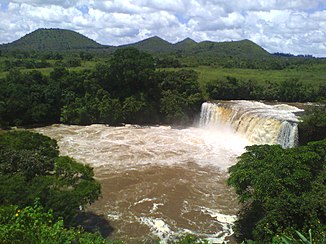
Waterfall at the Vina near Ngaundere |
||
The Vina is a river in Cameroon .
course
The river has its sources about 60 km southeast of the city of Ngaundere in the highlands of Adamaua , at an altitude of 1450 m near the village of Nangue. It initially flows about 50 km in a north-westerly direction. Near the city of Ngaundere, it changes course to the southwest. After another 70 km, it changes its course again to the south and finally flows into the Djérem.
Hydrometry
The flow rate of the river was measured in Lahoré in m³ / s

water falls
There are several waterfalls in the catchment area of the Vina which are considered to be tourist attractions. One of them is on its tributary Tello. The most famous is on the Vina, about 10 km south of Ngaundere directly on the N1 road .


