Vollrather height
| Vollrather height | ||
|---|---|---|
|
Vollrather height |
||
| height | 187 m above sea level NN | |
| location | Rhein-Kreis Neuss ( North Rhine-Westphalia ) | |
| Coordinates | 51 ° 3 '50 " N , 6 ° 36' 20" E | |
|
|
||
| Type | Recultivated waste dump | |
|
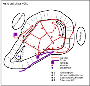
Map of the Vollrather Höhe |
||
|
Vollrather Höhe in the Rhenish lignite district |
||
|
Gut Vollrath memorial stone |
||
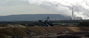
The Vollrather Höhe (sometimes also called Allrather Höhe ) is an overburden dump that was created when the former Frimmersdorf-West open-cast lignite mine (renamed Garzweiler open-cast mine since 1983 ) was opened . It was built up between 1955 and 1968 and has been open to the public since 1973.
location
It is located in North Rhine-Westphalia south of Grevenbroich in the Rhine district of Neuss, directly east of the Garzweiler opencast mine. The plateau at 165 m above sea level. NN is mostly used for agriculture. In the south-west and north-east there are wooded elevations as wind protection, the highest point at 187 m above sea level. NN lies.
Surname
The name of the overburden dump is the Vollrath estate , which stood on the site of the Vollrather Höhe until 1953. A memorial stone reminds of the exact place. The Drei Linden are also no longer in existence . According to legend, a virgin who was wrongly sentenced to death is said to have predicted that three linden trees would grow at the place of condemnation. A plaque reminds of the location of the three linden trees.
In addition to the official name, the name Allrather Höhe is also used in the region after the neighboring town of Allrath . Even today, the height is sometimes referred to as the Voll- / Allrath Kippe , depending on its former function .
Wind farm
Between 1995 and 1999 a total of 13 wind turbines were built on the Vollrather Höhe . The wind farm consisted of four Tacke TW-600 turbines with a nominal output of 600 kW and nine AN Bonus turbines with a nominal output of 1000 kW. The annual generation of the wind park was around 20.2 million kWh.
In 2013, another Enercon E-82 system was built for NEW AG . A few months later, a Vestas V90 system followed , for which a Tacke system was dismantled. In autumn 2016, the remaining old wind turbines from the 1990s were dismantled as part of repowering and replaced by five new General Electric 2.5-120 turbines with an output of 2.5 megawatts each. This means that there are currently only seven wind turbines on the Vollrather Höhe. With repowering, the wind farm will in future produce around three times as much electricity as before.
| Plant type | number | Construction year | Total height | Rotor diameter | Hub height | power | Remarks |
|---|---|---|---|---|---|---|---|
| Tacke TW-600 | 4th | 1995 | 71.5 m | 43 m | 50 m | 0.6 MW | Dismantled in 2014 and 2016 |
| Bonus B54 / 1000 | 9 | 1999 | 97 m | 54.1 m | 70 m | 1 MW | Dismantled in 2016 |
| Enercon E-82 | 1 | 2013 | 149 m | 82 m | 108 m | 2.3 MW | owned by NEW Re GmbH |
| Vestas V90 / 2000 | 1 | 2014 | 150 m | 90 m | 105 m | 2.0 MW | owned by CPC Germania |
| GE Wind 2.5-120 | 5 | 2016 | 180 m | 120 m | 120 m | 2.5 MW | 2 plants: CPC Germania; 3 plants: Encavis |
There are also two transmission masts on the Vollrather Höhe.
Road network
The plateau can be reached via residential streets from the districts of Neuenhausen , Allrath and Frimmersdorf . Hikers, but especially cyclists, use the driveway as a training opportunity in the otherwise flat area. The hiking trail X2 ( Kleve - Düren ) leads over the Vollrather Höhe or alternatively to the west past it. The Niederrheinroute cycle path and the Grevenbroich energy path run across Vollrather Höhe . In addition, the A1 circular hiking trail is marked on the Vollrather Höhe, which begins at the upper parking lot and also leads over the southwestern elevation.
The R15 cycle path and the Euroga cycle path between the Rhine and Maas lead past the Vollrather Höhe .
See also
- Wiedenfelder Höhe
- Glessener height
- Sophienhöhe , recultivated waste dump near Jülich
- Rhenish lignite district
Web links
Individual evidence
- ^ In: Revier und Werk, magazine for the operations of the Rheinischen lignite mining, 1973, issue 115, p. 28f.
- ^ Aachener Zeitung: First wind turbine in Grevenbroich: "Milestone" for NEW Re GmbH. February 21, 2013, accessed May 25, 2020 .
- ↑ Five XXL wind turbines replace old systems . In: NGZ-Online , October 12, 2016. Accessed December 19, 2016.


