Wörthspitze

The Wörthspitze is a park in the Nied district of Frankfurt . It is part of the Frankfurt green belt , which has its starting point here. The large lawn of the Wörthspitze serves as a public dog run and is used as a lawn and play area in summer.
location
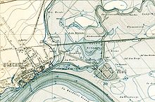
The Nidda is close to its mouth in the amount of Bolongaropalastes together with the Main elongated peninsula Wörthspitze. The name “Wörth” is derived from “Werde” or “Werder” , a name for a river island or bank location on the river.
The Wörthspitze can be reached on foot or by bike. From Höchst the "Gaasebrickelsche" (High German: "Geißen-" or "Ziegenbrücklein") spans the Nidda across from the Amtsgasse. In Nied, several park paths lead from Mainzer Landstrasse at the level of the Neue Nieder Niddabrücke to the Wörthspitze.
history
Originally, the Wörthspitze was a river island between the Nidda and Main, which was surrounded by two branches of the Nidda estuary. The eastern branch of the estuary silted up over time and became a regularly flooded marshland; a map created around 1540 shows the marshland as " the arm or gall on the Main to the Nied ". By 1800, the bottom piece was drained, it was the Niedschütt .
From the Middle Ages to the early 20th century, the Wörthspitze was used for agriculture. It served as arable land, pasture and hay meadow. Since there was no bridge connection between the high Höchst Ufer and the Wörthspitze, which is at the same level as the river, it could only be reached via the Nieder Brücke. The mouth of the Nidda served as a berth for the boats of the Höchst Main fishermen and, until the construction of the Höchst port in 1908, also served as a river port.
In 1913 the city of Höchst had a pedestrian bridge built over the Nidda at the level of the Amtsgasse. Since the goats were driven to the Wörthspitze here, the bridge is still called "Gaasebrickelsche" in the Höchst vernacular. It is sometimes called the "Bridge of Sighs" because of its shape, which is reminiscent of the arched bridges of Venice . The arch bridge is 41.9 meters long and has a span of 23 meters.
After the First World War , the Wörthspitze and the Höchst City Park served as parade and parade grounds for the French occupation troops stationed in Höchst. With the end of the Rhineland occupation in 1930, the Wörthspitze was redesigned into a park. Footpaths and bike paths have been laid out and poplar trees have been planted.
During the time of National Socialism , the NSDAP inaugurated a Thingplatz at the Wörthspitze in April 1934 . In 1937 a memorial was erected for the Höchst and Nieder, who died in World War I, with a larger-than-life kneeling naked warrior by Richard Scheibe . This memorial was demolished in 1965. Only a walled bastion on the banks of the Main, which serves as a viewing platform, testifies to it.
In 1961 the hotel ship "Peter Schlott" was anchored in the Nidda estuary opposite the Wörthspitze. The two houseboats lying in the Nidda estuary were also moored in the 1960s. There is no official mooring permit for the houseboats, which is why they have often been the focus of public discussions about landscape protection on the Nidda. The owners of the boats are currently not paying any mooring fees, as the City of Frankfurt would officially recognize the houseboats against its declared will by charging mooring fees. So they are tacitly tolerated.
The Frankfurt Green Belt, established in 1991, begins at the Wörthspitze . The Frankfurt poet and draftsman Robert Gernhardt (1937–2006) claims to have seen the Frankfurt green armadillo for the first time at the Wörthspitze. In 2002 the city of Frankfurt planted three ash trees named after him on the Wörthspitze in honor of Gernhardt.
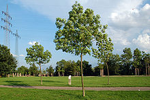
From autumn 2006 to spring 2007 the Wörthspitze was redesigned. The last of the old poplars were felled and a number of walnut trees were planted. The middle of the previously three parallel paths has been removed and converted into a green area; the southern path directly on the banks of the Main was re-paved, as was the square at the level of the former memorial.
literature
- Markus Grossbach: Frankfurt-Höchst. History 1860-1960. Illustrated book. Erfurt 2001: Sutton.
- Rudolf Schäfer: Höchst am Main. Frankfurt am Main 1981: Frankfurter Sparkasse from 1822.
- Rudolf Schäfer: Chronicle of Höchst am Main. Frankfurt am Main 1986: Waldemar Kramer.
Web links
- 360 ° view of the Wörthspitze
- Gernhardt-Eschen on the Wörthspitze at par.frankfurt.de , the former website of the City of Frankfurt am Main
Individual evidence
- ^ The Nidda at frankfurt.de
- ^ Adalbert Vollert: Nied am Main. Chronicle of a Frankfurt district. Frankfurt am Main 1998: Local history and history association Nied. P. 20
- ↑ Route of industrial culture Rhein Main, Frankfurt am Main - West (PDF)
- ↑ Reporting by the Frankfurter Rundschau and the Höchst Kreisblatt in March 2007
Coordinates: 50 ° 6 ′ 1 ″ N , 8 ° 33 ′ 25 ″ E


