
Woldegk
| coat of arms | Germany map | |
|---|---|---|

|
Coordinates: 53 ° 28 ' N , 13 ° 35' E |
|
| Basic data | ||
| State : | Mecklenburg-Western Pomerania | |
| County : | Mecklenburg Lake District | |
| Office : | Woldegk | |
| Height : | 114 m above sea level NHN | |
| Area : | 133.86 km 2 | |
| Residents: | 4315 (Dec. 31, 2019) | |
| Population density : | 32 inhabitants per km 2 | |
| Postal code : | 17348 | |
| Primaries : | 03963, 03964, 03967, 039753, 039859 | |
| License plate : | MSE, AT, DM, MC, MST, MÜR, NZ, RM, WRN | |
| Community key : | 13 0 71 164 | |
| LOCODE : | DE WDQ | |
City administration address : |
Karl-Liebknecht-Platz 1 17348 Woldegk |
|
| Website : | ||
| Mayor : | Ernst-Jürgen Lode | |
| Location of the city of Woldegk in the Mecklenburg Lake District | ||
  |
||

Woldegk is a country town in the Mecklenburg Lake District in southeast Mecklenburg-Western Pomerania . It is the seat of the Woldegk office , to which six other municipalities belong. Since July 14, 2008, Woldegk has been known as “Windmühlenstadt” because of its six historic windmills . The place is a basic center and is located around 25 km southeast of the regional center of Neubrandenburg . As a country town, Woldegk was part of the historic cultural region of Mecklenburg-Strelitz .
geography
Geographical location
The city lies on the border with the Brandenburg district of Uckermark in the ground moraine area south of the Helpter Mountains . With over 100 m above sea level NHN , Woldegk is one of the highest places in Mecklenburg-Western Pomerania.

Dammsee in the Hildebrandshagen district
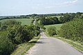
Road in the Helpter Mountains

Kornowsee in Grauenhagen

Hinrichshagen forest


City structure
The city of Woldegk consists of 19 districts:
history
Surname
Woldegk is a high medieval castle name that can be interpreted in High German as Waldeck (e) . The name is composed of wold for forest and egge or egke for corner or edge. A castle at the top of the Helpter Mountains used to be in a more wooded area. The spelling changed from de Woldegen (1230) de Woldegge (1271), Woldegge (1208) to Woldekke (1305) and Woldegge (1440).
founding
The establishment of the planned settlement is dated between 1236 and 1250. The first city coat of arms is proven in 1271 and suggests a Brandenburg foundation.
As a result of the marriage of the margrave's daughter Beatrix of Brandenburg to Heinrich von Mecklenburg in 1292, Woldegk came into the hands of the princes, later (grand) dukes of Mecklenburg , as part of the Stargard rule . In 1298 the city was mentioned as a civitas . Woldegk became a country town in Mecklenburg and, as such, part of the towns in the Stargardian district , which were represented on the Mecklenburg regional parliaments of the territories united in 1523 until 1918 .
middle Ages

Woldegk was designed as a grid with an oval outline. The early Gothic town church was built as a stone building in the second half of the 13th century. After a fire in 1442, the parish church of St. Petri was converted into a three-aisled hall church using bricks . It was badly destroyed in 1945 and then rebuilt. In 1955 it was given a flat ceiling instead of a cross vault . In the 14th century, a city wall made of field stones with three double gates , Wiek houses , ramparts , trenches and a fishing tower was built.
Modern times

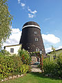
The first post mill was built on the Mühlenberg in 1587 . In 1635 there were four windmills in Woldegk , the number of which increased to seven by 1745. Between 1859 and 1893 six post windmills were demolished and Erdholländer windmills were built in their place . In 1701 the city came to the (partial) duchy of Mecklenburg-Strelitz . The town hall from 1763 was originally located in the middle of a square central market square. Woldegk experienced an economic boom between 1892 and 1912, combined with the connection to the Mecklenburg Friedrich-Wilhelm Railway through the Woldegker Kleinbahn . During this time, a sugar factory , a steam plow factory, two brickworks , a gas works and a water works were built in Woldegk.
On June 29, 1764, the Woldegk region was hit by a devastating tornado of the class F5 , which is rarely found in Germany . Over a distance of almost 30 km from Feldberg to Helpt , the cyclone left a swath of devastation up to 900 m wide. Woldegk himself was spared.
After 1945

At the end of the Second World War , the city was 70% destroyed and partially rebuilt in the following period. The railway line was dismantled and the tracks were brought to the Soviet Union as reparations . According to the tradition as a mill town, the mill museum was opened in 1969. After the German reunification, an economic decline set in. From 1991, as part of were urban development , large parts of the historic center rehabilitated and war-related vacant lots closed.
From 1952 to 1994 Woldegk belonged to the Strasburg district (GDR district Neubrandenburg / State of Mecklenburg-Western Pomerania ), from 1994 to the district of Mecklenburg-Strelitz and has been in the Mecklenburg Lake District since 2011 .
History of today's districts
From 1476 onwards, Canzow was temporarily owned by the Himmelpfort monastery as a pledge .
Helpt was first mentioned in 1298 and for a long time was the site of the castle, with the castle hill that has been restored today. The church of Helpt dates from the second half of the 13th century. The estate was owned by the Bredow families (from 1455), von Oertzen (from 1665), von Rhaden (from 1753), von Dewitz (from 1782) and von Bodenhausen (from 1911). The manor house dates from 1884.
Mildenitz was a manor village that was owned by the von Schwerin family from 1680 to 1945 . The classicist manor house was built around 1800. The half-timbered church dates from the 18th century.
Oertzenhof was a manor village of the Oertzen . In 1866 the station on the Wittenberge – Strasburg line was built . A district enterprise for agricultural engineering was located in the GDR.
Rehberg: The estate was owned by the Sonneke families (16th century), von Tornow (1718–1741) and then a domain . The single-storey manor house from the mid-19th century was renovated in 2000.
Vorheide was managed as a domain from Rehberg. The Vorwerk was built in 1778, and in 1853 it became an independent domain. The ruinous manor house, built for Franz Boldt, dates from the 19th century.
Incorporations
- Canzow on July 1, 1950
- Hildebrandshagen on January 1, 1973
- Bredenfelde, Grauenhagen, Hinrichshagen and Rehberg on June 13, 1999
- Goehren on January 1, 2002
- Help on May 25, 2014,
- Mildenitz on January 1, 2015
- Petersdorf on May 26, 2019
Population development
|
|
Status: December 31 of the respective year
politics
City council
The city council of Woldegk consists of 15 members and the mayor. Since the local elections on May 26, 2019, it has been composed as follows:
| Party / list | Seats |
|---|---|
| CDU | 6th |
| Citizens' group for Woldegk | 4th |
| SPD | 4th |
| AfD | 1 |
mayor
- since 2004: Ernst-Jürgen Lode
Lode was confirmed in office for another five years in the mayoral election on May 26, 2019, with 73 percent of the valid votes.
coat of arms
|
|
Blazon : “In silver a torn green oak with eight fruits; between the branches a golden armed red eagle. "
The coat of arms was redrawn before 1978 and registered under number 73 of the coat of arms of the state of Mecklenburg-Western Pomerania. |
| Justification for the coat of arms: The coat of arms was designed according to the large city seal - fragmented as an imprint in 1307. The oak as a talking symbol creates a visual reference to the Low German place name Woldeggke (= Waldecke), the red eagle, the symbol of power of the Ascanian Margraves of Brandenburg, refers to the city's founders and city lords until around 1300. |
- Historical coat of arms
 |
Blazon : "In silver a torn green oak with four fruits, a red eagle between the branches."
The coat of arms was designed by Hans Herbert Schweitzer . It was awarded on September 14, 1940 by the Reichsstatthalter in Mecklenburg. |
| Justification of the coat of arms: The coat of arms lost its validity soon after the end of World War II. |
flag
The flag was designed by Hans-Ullrich Hoffmann from Woldegk and approved on May 11, 2000 by the Ministry of the Interior.
The flag is striped in green, white and green across the longitudinal axis of the flag cloth. The green stripes each take up a quarter, the white stripe takes up half the length of the flag cloth. The center of the white stripe is covered with the figures of the city's coat of arms: with a torn green oak and eight fruits; between the branches with a yellow armed red eagle. The figures take up a total of two thirds of the height and one third of the length of the flag cloth. The length of the flag is related to the height as 5: 3.
Official seal
The official seal shows the city coat of arms with the inscription "WINDMÜHLENSTADT WOLDEGK".
Attractions

→ See also the list of architectural monuments in Woldegk
Buildings
Woldegk
- City church St. Petri from around 1250: the choir , sacristy and tower substructure made of field stones are preserved. The three-aisled nave from 15./16. Century made of brick was destroyed in 1945 and rebuilt in a simplified way by 1957. The upper half of the tower was reconstructed in 2006/2007.
- City wall, built from field stones in the 14th century, has been preserved over a length of approx. 700 meters.
Districts
- Village church in Bredenfelde , field stone building from the late 13th century with a brick tower from 1864
- Village church in Canzow, 1888 and 1893, neo-Gothic brick building
- Village church in Göhren (PICTURES) , rectangular field stone hall , south portal and arches around south window of Gothic brick; other brick parts from the end of the 19th century.
- Chapel in Grauenhagen as a plastered building
- Village church in Helpt , 2nd half of the 13th century, field stone building with brick choir windows
- Village church in Hildebrandshagen, 1580, half-timbered building
- Village church in Hinrichshagen (PICTURES) , 14th century, field stone building with brick gable and half-timbered tower
- Church ruins in the Hinrichshagen forest
- Village church in Mildenitz, 18th century, half-timbered building
- Manor house (manor house) Mildenitz from around 1800 and 1850
- Village church in Pasenow (PICTURES) , consecrated in 1476, boulder masonry with somewhat late Gothic brick decoration
- Village church in Rehberg, 1737, half-timbered building
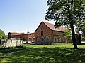
- Manor complexes in Bredenfelde (1855), Georginenau, Göhren, Grauenhagen, Helpt, Hildebrandshagen and Vorheide.
Estate in Göhren

Rothe Church, ruins in the Hinrichshagen Forest

Bredenfelde, church

Helpt, Baroque altar in the church

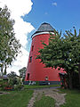
Woldegk, water tower

Mildenitz, church
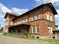
Oertzenhof, train station
_2011-05-06_068.JPG)


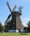
Mills in Woldegk
Of the six Woldegker mills, the museum mill and the Ehlertsche mill were extensively renovated in 1993. In 1994 the Mühlendamm was rebuilt.
- Museum mill
- Ramme cafe-mill
- Ehlertsche Mühle (Technical Monument)
- Seemühle, Fröhlckesche Mühle
- Pottery Mill Saalfeld (Gotteskampmühle)
- Kreienbrink mill ruin (monument, Kreienbringsche Mühle)

Woldegk Museum Mill (Erdholländer)
Ramme cafe-mill
Ehlert mill

Seemühle (Fröhlkesche Mühle)
Pottery Mill (Gotteskampmühle)

Kreienbringsche Mühle (ruin)


Historical monuments
Goehren
- Memorial plaque from 1987 in the church for the resistance fighter Ulrich-Wilhelm Graf Schwerin von Schwanenfeld as a participant in the assassination attempt on July 20, 1944 on Hitler, who was executed in Berlin-Plötzensee in 1944.
- Memorial stone in the castle park to Ulrich-Wilhelm Graf Schwerin von Schwanenfeld
Woldegk
- Memorial to the fallen of 1870/71
- Honor grove with a memorial to the fallen of the First and Second World Wars
- Monument from 1951 in Neutorstrasse for the victims of fascism
- Soldiers graves in the cemetery of Woldegk (four unknown German soldiers - killed in 1945)
Economy and Infrastructure
traffic

The federal highways 104 ( Neubrandenburg - Stettin ) and 198 ( Neustrelitz - Prenzlau ) cross in Woldegk . The closest motorway junction is Friedland iM on the A 20 (Neubrandenburg– Dreieck Uckermark ).
The Oertzenhof stop in the district of Woldegk (about 8 km from the city center) is on the Bützow – Szczecin railway line . Trains on the RE 4 Regional Express line ( Lübeck - Szczecin ) stop there . The station Woldegk was on the railway line Wittenberge-Strasburg , whose section Thurow - Strasburg after the Second World War as reparations to the Soviet Union was dismantled.
education
- Regional school with elementary school "Wilhelm Höcker", Wollweberstrasse 27
Personalities of the city and its current districts
Sons and daughters
Goehren
- Wilhelm Graf Schwerin von Schwanenfeld (* 1929), President of Johanniter-Unfall-Hilfe
- Detlef Graf von Schwerin (* 1944), historian and police chief
Hildebrandshagen
- Otto von Blanckenburg (1535–1605), Commander of the Teutonic Order of Langeln in the Saxony Ballei
Hinrichshagen
- Rudolf Doehn (1821–1895), writer and US politician
- Kurt Freiherr von Hammerstein-Equord (1878–1943), general and member of the military resistance against Hitler
- Gerhard Friedrich Kegebein (1773–1813), poet and original in the Reuter-Humoreske Dörchläuchting .
Woldegk
- Johann Gottfried Rosenberg (1709–1776), architect
- Juliusz Kolberg (1776–1831), Professor of Geodesy at Warsaw University
- Albert Reinhold (1805–1850), poet
- Werner Reinhold (1806–1863), philologist and writer
- Carl Marung (1813–1890), doctor, member of the Mecklenburg Assembly of Representatives
- Max Marung (1839-1897), doctor
- Franz Schütt (1859–1921), botanist and university professor
- Walther Gothan (1879–1954), geologist and paleobotanist
- Margarethe Lachmund (1896–1985), Quaker, resistance fighter and peace activist
- Hanna Wolf (* 1936), politician (SPD)
- Rüdiger Messal (* 1952), political official
- Roland Gehrke (* 1954), wrestler
- Wolfram Meyerhöfer (* 1970), mathematics teacher and university professor
Other personalities
Goehren
- Ulrich Wilhelm Graf Schwerin von Schwanenfeld (1902–1944), member of the military resistance against Hitler
Hinrichshagen
- Philipp Wilhelm Prozell (1792–1888), pastor in Hinrichshagen 1834–1876 and meteorologist
- Minna Rüdiger (1841–1920), nationally known writer and wife of the pastor, who died in 1895
Woldegk
- Daniel Runge (1804–1864), theologian, pastor, member of the Mecklenburg parliamentary assembly
- Adolph Runge (1816–1862), physician, Member of the Pre-Parliament
- Friedrich Ludwig Reinhold (1766–1832), pastor and educator
literature
- Literature about Bredenfelde in the state bibliography MV
- Literature about Canzow in the state bibliography MV
- Literature about Göhren in the state bibliography MV
- Literature about Grauenhagen in the state bibliography MV
- Literature about Helpt in the state bibliography MV
- Literature about Hildebrandshagen in the state bibliography MV
- Literature about Hinrichshagen in the state bibliography MV
- Literature about Mildenitz in the state bibliography MV
- Literature about Petersdorf in the state bibliography MV
- Literature about Woldegk in the state bibliography MV
Web links
- Village history from Hildebrandshagen on April 29, 2019 on ndr.de (Nordmagazin)
Individual evidence
- ↑ Statistisches Amt MV - population status of the districts, offices and municipalities 2019 (XLS file) (official population figures in the update of the 2011 census) ( help ).
- ↑ Regional Spatial Development Program Mecklenburg Lake District (2011) , Regional Planning Association, accessed on July 12, 2015
- ^ Main statute of the city of Woldegk
- ↑ Ernst Eichler, Werner Mühlner: The names of the cities in Mecklenburg-Western Pomerania . Ingo Koch Verlag, Rostock 2002, ISBN 3-935319-23-1 .
- ↑ Gottlob Burchard Genzmer : Complicated and reliable description of the hurricane, which on June 29th, 1764, devastated a line of several miles in the Stargardian district of the Duchy of Mecklenburg. Nicolai, Berlin / Stettin 1765 ( digitized version )
- ↑ Henning Strüber: June 29, 1764: The Millennium Tornado by Woldegk , NDR.de of June 28, 2014
- ↑ Municipalities 1994 and their changes since January 1, 1948 in the new federal states , Metzler-Poeschel publishing house, Stuttgart, 1995, ISBN 3-8246-0321-7 , publisher: Federal Statistical Office
- ↑ StBA: Changes in the municipalities in Germany, see 1999
- ↑ StBA: Changes in the municipalities in Germany, see 2002
- ^ Statistical Office Mecklenburg-Western Pomerania: Area changes in Mecklenburg-Western Pomerania, 18.1. until March 15, 2014
- ^ Statistical Office Mecklenburg-Western Pomerania: Area changes in Mecklenburg-Western Pomerania, 1.1. until 6.1.2015 ( memento from January 13, 2015 in the Internet Archive ), accessed on January 13, 2015
- ↑ Announcement of the Ministry of the Interior and Europe of January 16, 2019, Official Gazette. MV p. 254
- ↑ Population development of the districts and municipalities in Mecklenburg-Western Pomerania (Statistical Report AI of the Statistical Office Mecklenburg-Western Pomerania)
- ^ City council of Woldegk
- ^ The incumbent Ernst-Jürgen Lode remains Woldegk's mayor. In: Nordkurier , May 27, 2019.
- ↑ a b Hans-Heinz Schütt: On shield and flag - the coats of arms and flags of the state of Mecklenburg-Western Pomerania and its municipalities . Ed .: production office TINUS; Schwerin. 2011, ISBN 978-3-9814380-0-0 , pp. 304/305 .
- ↑ a b main statute § 3 (PDF).
Bredenfelde | Canzow | Carlslust | Georginenau | Goehren | Grauenhagen | Groß Daberkow | Helps | Hildebrandshagen | Hinrichshagen | Hornshagen | Mildenitz | Oertzenhof | Oltschlott | Pasenow | Petersdorf | Rehberg | Vorheide | Woldegk
Alt Schwerin | Altenhagen | Altenhof | Altentreptow | Ankershagen | Bartow | Basedow | Beggerow | Ownership | Blankenhof | Blankensee | Flower wood | Bollewick | Borrentine | Bredenfelde | Breesen | Breest | Briggow | Brunn | Buchholz | Stargard Castle | Burow | Bütow | Carpin | Cölpin | Dargun | Datzetal | Demmin | Eldetal | Rotten rust | Feldberger Seenlandschaft | Fincken | Friedland | Five lakes | Galenbeck | Gielow | Gnevkow | Godendorf | Goehren-Lebbin | Golchen | Gotthun | Grabowhöfe | Grammentin | Grapzow | Grischow | Large trowel | Groß Miltzow | Gross Nemerow | Large plastic | Groß Teetzleben | Grünow | Validity | Gülzow | High Wangelin | Hohenbollentin | Hohenmocker | Hohenzieritz | Holldorf | Ivenack | Jabel | Jürgenstorf | Kargow | Kentzlin | Kieve | Kittendorf | Little Thank You | Kletzin | Klink | Klocksin | Knorrendorf | Kratzeburg | Kriesow | Sublank | Kuckssee | Kummerow | Larz | Leizen | Lindenberg | Lindetal | Malchin | Malchow | Meesiger | Melz | Mirow | Möllenbeck | Möllenhagen | Mölln | Moltzow | Neddemin | Neetzka | Neubrandenburg | Neuenkirchen | Recalculation | Neustrelitz | Neverin | Nossendorf | Nossentiner Hut | Peenehagen | Penkow | Penzlin | Pragsdorf | Priborn | Priepert | Pripsleben | Rechlin | Ritzerow | Röbel / Müritz | Röckwitz | Rosenow | Sarov | Schloen-Dratow | Schönbeck | Schönfeld | Schönhausen | Black | Siedenbollentin | Siedenbrünzow | Sietow | Silz | Sommersdorf | Sponholz | Staven | Stavenhagen | Steer | Südmüritz | Torgelow am See | Trollenhagen | Tützpatz | Userin | Utzedel | Forgive | Voigtsdorf | Vollrathsruhe | Walow | Waren (Müritz) | Warrenzin | Werder | Wesenberg | Wildberg | Woggersin | Wokuhl-Dabelow | Wolde | Woldegk | Wulkenzin | Wustrow | Zettemin | Zirzow | Zislow