
To close
| To close | |
|---|---|
 |
|
| State : |
|
| Canton : |
|
| District : | Rheinfelden |
| BFS no. : | 4264 |
| Postal code : | 4315 |
| Coordinates : | 634 826 / 263 862 |
| Height : | 377 m above sea level M. |
| Height range : | 360–638 m above sea level M. |
| Area : | 8.39 km² |
| Residents: | 866 (December 31, 2019) |
| Population density : | 103 inhabitants per km² |
|
Proportion of foreigners : (residents without citizenship ) |
12.9% (December 31, 2019) |
| Website: | www.zuzgen.ch |
 View of the village of Zuzgen |
|
| Location of the municipality | |
  |
|
Zuzgen ( Swiss German : ˈtsʊtsgə ) is a municipality in the Swiss canton of Aargau . It belongs to the Rheinfelden district , is located in the west of the Fricktal region around three kilometers southwest of the border with Germany and borders the canton of Basel-Landschaft .
geography
The village is located in the central part of the Möhlintal , which is traversed by the Möhlinbach from southeast to northwest . There are two historical settlement centers that have now grown together: the village of Zuzgen in the narrower sense and Niederhofen around four hundred meters down the valley. The flat valley floor is on average almost 200 meters wide and is bordered by several hills of the Table Jura . In the lower area, they are very steep in places and in the upper area they merge into extensive plateaus on which agriculture is carried out. In the north lies the almost circular Chriesiberg ( 558 m above sea level ). To the east of the village is the Looberg ( 581 m above sea level ) with the hamlet of the same name ( 569 m above sea level ). Its plateau is about one kilometer wide and extends over a length of more than four kilometers in a south-easterly direction (at Hellikon the plain is called Wabrig, at Wegenstetten Hersberg). The Reckental, which is more than two kilometers long, branches off to the south. To the west of this extends another extensive plateau with the hamlet of Erfleten ( 568 m above sea level ). The Chriesiberg, on which there are around 300 cherry trees, is the last unspoilt high plateau of the Swiss Table Jura. It is a landscape protection zone of national importance.
The area of the municipality is 839 hectares, of which 290 hectares are forested and 48 hectares are built over. The highest point is at 637 meters on the southern border of the municipality, the lowest at 360 meters on the Möhlinbach. The municipality of Zuzgen is part of the Aargau Jura Park, a “Regional Nature Park of National Importance”. Neighboring communities in Aargau are Zeiningen in the northwest, Mumpf in the north, Obermumpf in the northeast and Hellikon in the southeast. To the southwest, Zuzgen borders the municipality of Buus in the canton of Basel-Landschaft.
history

There is evidence that the area around Zuzgen was already settled during Roman times, as evidenced by some coin finds and remains of the wall. The Alemanni left well-preserved graves. In 1288, the first documentary mention of Zuzchon was in a document from the Johanniterkommende Rheinfelden . The village name comes from the Old High German Uzinghofun and means “at the farms of the Uzo clan”. The most important landowner was the Säckingen women's monastery , which also had lower jurisdiction . From the 13th century the monastery had its Dinghof , which in addition to Zuzgen also included Hellikon and parts of Zeiningen and Wegenstetten , administered by the Lords of Stein as Meier , and from the middle of the 14th century onwards by the Lords of Schönau .
The exercising of blood jurisdiction was the responsibility of the respective guardian of the monastery. Initially these were the Lenzburgers , later the Habsburgs . After the Waldshut War of 1468, the latter pledged the entire Fricktal to Burgundy . When the Burgundians were defeated by the Confederates during the Burgundian Wars , Zuzgen came under Austrian rule again in 1477. As a result of the imperial reform of the Austrian Emperor Maximilian I , Zuzgen belonged to Upper Austria from 1491 and was located in the Möhlinbach region , a subordinate administrative unit of the Rheinfelden cameramen (from 1752 in the Breisgau Upper Office ). In the 17th century there were hardly any longer times of peace. The Rappenkrieg , a peasant uprising, lasted from 1612 to 1614. The Thirty Years War , which also affected the Fricktal between 1633 and 1638, threw the village back in its economic development. Foreign troops also moved through the region during the War of the Palatinate Succession (1688–1697).
In 1797 the Fricktal became a French protectorate after the Peace of Campo Formio . During the Second Coalition War , the front line between the armies of France and Austria ran here . On February 20, 1802, Zuzgen became a municipality in the Rheinfelden district of the Fricktal canton , which joined the Helvetic Republic in August . The municipality has belonged to the canton of Aargau since February 19, 1803. On July 2nd, 1801, a major fire destroyed most of the houses in the village. A typhus epidemic twelve years later and several bad harvests resulted in many residents becoming impoverished and forced to emigrate. In addition to agriculture, which dominated well into the 20th century, there were only a few opportunities to earn money in the industrial establishments in neighboring communities. The wine-growing on the southern slopes of Chriesiberg and Looberg disappeared in the 19th century.
The parish of Zuzgen, which had existed at least since 1288, also included the left bank of Hellikon. This was assigned to the parish of Wegenstetten in 1788 as part of the Josephine reforms . A significant part of the population converted to the Christian Catholic denomination during the Kulturkampf in 1873 (organized in the parish of Wegenstetten since 1898). In 1901/02, the Roman Catholics erected their own church building opposite the old parish church used by the Christ Catholics. For decades the population remained stable or even decreased slightly. Since the beginning of the 1980s, however, there has been increased construction activity as more and more people are moving here from the city of Basel and its suburban suburbs. The number of inhabitants has increased by over 50 percent since then.
coat of arms
The blazon of the municipal coat of arms reads: "In blue on three green hills five green fir trees, overlaid by a six-pointed yellow star." The coat of arms with the five fir trees was first depicted on the municipal seal from 1872 , but no colors can be read from the hatching . The green-blue color combination came up around 1945. From a heraldic point of view, this is an unsuitable combination, since the two colors neutralize each other and the coat of arms cannot have a long-range effect. A change proposed in 2002 (yellow sign and red star) was rejected by the local council.
Attractions
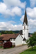
At the upper entrance to the village, on both sides of the main road, two churches face each other. The older is the Christian Catholic St. George's Church , which was built in 1737/38 under the direction of the renowned master builder Johann Caspar Bagnato . The baroque building was originally Roman Catholic, passed to the Christian Catholics in 1878 and was then used equally for two decades. Since the Roman Catholics were forbidden to celebrate the Lord's Supper in it due to an instruction from the Vatican, they decided to build the neo-Gothic parish church of St. Georg , which was built in 1901/02 according to plans by the architect August Hardegger .
Next to the Christian Catholic church is the parish store , which was built in 1723 to store the tithes of the Säckingen women's monastery. A few farmhouses and houses from the 18th and 19th centuries have been preserved on Schulstrasse in particular. On the Looberg there is an art gallery with works by the sculptor Paul Agustoni.
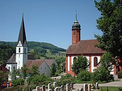
The churches of Zuzgen
Parish Church of St. George

Christian Catholic Church

school

School complex

Community center


population
The population developed as follows:
| year | 1768 | 1850 | 1900 | 1930 | 1950 | 1960 | 1970 | 1980 | 1990 | 2000 | 2010 | 2015 |
| Residents | 308 | 775 | 606 | 575 | 587 | 624 | 595 | 545 | 646 | 729 | 848 | 859 |
On December 31, 2019, 866 people lived in Zuzgen, the proportion of foreigners was 12.9%. In the 2015 census, 40.2% described themselves as Roman Catholic , 24.0% as Reformed and 4.5% as Christian Catholic ; 31.3% were non-denominational or of other faiths. 97.8% said German as their main language in the 2000 census and 1.1% Albanian .
Politics and law

The assembly of those entitled to vote, the municipal assembly , exercises legislative power. The executing authority is the five-member municipal council . He is elected by the people in the majority procedure, his term of office is four years. The parish council leads and represents the parish. To this end, it implements the resolutions of the municipal assembly and the tasks assigned to it by the canton. The Rheinfelden District Court is the first instance responsible for legal disputes . Zuzgen belongs to the Friedensrichterkreis XIV (Rheinfelden).
economy
According to the company structure statistics (STATENT) collected in 2015, there are around 230 jobs in Zeiningen, of which 24% are in agriculture, 11% in industry and 75% in the service sector. Most of the employed people are commuters and work in the larger communities of the Fricktal and in the agglomeration of the city of Basel .
traffic
Zuzgen is on canton road 494, which runs from Möhlin through the Möhlintal to Wegenstetten . Smaller side streets lead to Mumpf and Buus . The closest connection to the A3 motorway is near Rheinfelden . The connection to the public transport network is made by a post bus line from Möhlin train station to Wegenstetten. On weekends a night bus runs from Möhlin through the Möhlintal and Fischingertal back to Möhlin.
education
The community has a kindergarten and a primary school (1st to 6th grade). The secondary school and the district school are run together with the entire Möhlintal in Möhlin , the secondary school can be attended in Wegenstetten . On the basis of an inter-cantonal agreement, young people from parts of the Fricktal can complete high school in Muttenz ( Canton Basel-Landschaft ) or in Basel .
Personalities
- Otto Frey (sculptor) (also Otto Frey-Thilo ; 1916–2004), Swiss sculptor
- Hottinger, Josef (1900–1988), painter
- Joseph Hürbin (1863–1912), historian
literature
- Dominik Sauerländer: Zuzgen. In: Historical Lexicon of Switzerland .
- Edith Hunziker, Peter Hoegger: The art monuments of the canton of Aargau . Ed .: Society for Swiss Art History . Volume IX, Rheinfelden district. Bern 2011, ISBN 978-3-906131-94-8 , pp. 457-471 .
Web links
Individual evidence
- ↑ Cantonal population statistics 2019. Department of Finance and Resources, Statistics Aargau, March 30, 2020, accessed on April 2, 2019 .
- ↑ Cantonal population statistics 2019. Department of Finance and Resources, Statistics Aargau, March 30, 2020, accessed on April 2, 2019 .
- ↑ a b Beat Zehnder: The community names of the canton of Aargau . In: Historical Society of the Canton of Aargau (Ed.): Argovia . tape 100 . Verlag Sauerländer, Aarau 1991, ISBN 3-7941-3122-3 , p. 493-494 .
- ^ National map of Switzerland, sheet 1068, Swisstopo.
- ↑ Portrait. Community of Zuzgen, accessed on May 11, 2019 .
- ↑ Standard area statistics - municipalities according to 4 main areas. Federal Statistical Office , November 26, 2018, accessed on May 11, 2019 .
- ↑ a b c Hunziker, Hoegger: The art monuments of the canton of Aargau. P. 457.
- ^ Joseph Galliker, Marcel Giger: Municipal coat of arms of the Canton of Aargau . Lehrmittelverlag des Kantons Aargau, book 2004, ISBN 3-906738-07-8 , p. 330 .
- ↑ Hunziker, Hoegger: The monuments of the Canton of Aargau. P. 464.
- ↑ Hunziker, Hoegger: The monuments of the Canton of Aargau. P. 459.
- ↑ Hunziker, Hoegger: The monuments of the Canton of Aargau. P. 469.
- ↑ Population development in the municipalities of the Canton of Aargau since 1850. (Excel) In: Eidg. Volkszählung 2000. Statistics Aargau, 2001, archived from the original on October 8, 2018 ; accessed on May 11, 2019 .
- ↑ Resident population by religious affiliation, 2015. (Excel) In: Population and Households, Community Tables 2015. Statistics Aargau, accessed on May 11, 2019 .
- ↑ Swiss Federal Census 2000: Economic resident population by main language as well as by districts and municipalities. (Excel) Statistics Aargau, archived from the original on August 10, 2018 ; accessed on May 11, 2019 .
- ↑ circles of justice of the peace. Canton of Aargau, accessed on June 19, 2019 .
- ↑ Statistics of the corporate structure (STATENT). (Excel, 157 kB) Statistics Aargau, 2016, accessed on May 11, 2019 .