Saint-Benoît-Labre: Difference between revisions
Content deleted Content added
m Mattximus moved page Saint-Benoît-Labre, Quebec to Saint-Benoît-Labre: Disamb not needed |
m Repair or remove missing or deleted templates |
||
| (8 intermediate revisions by 6 users not shown) | |||
| Line 1: | Line 1: | ||
{{Use Canadian English|date=January 2023}} |
|||
{{Expand French|Saint-Benoît-Labre|date=December 2018|topic=geo}} |
|||
{{Infobox settlement |
{{Infobox settlement |
||
|name = Saint-Benoît-Labre |
|name = Saint-Benoît-Labre |
||
| Line 5: | Line 7: | ||
|other_name = |
|other_name = |
||
|settlement_type = [[Municipality (Quebec)|Municipality]] |
|settlement_type = [[Municipality (Quebec)|Municipality]] |
||
|image_skyline = |
|image_skyline = Chemin vers Saint Georges de Beauce - panoramio.jpg |
||
|imagesize = |
|imagesize = |
||
|image_caption = |
|image_caption = |
||
| Line 95: | Line 97: | ||
'''Saint-Benoît-Labre''' is a municipality in the [[Beauce-Sartigan Regional County Municipality|Municipalité régionale de comté de Beauce-Sartigan]] in [[Quebec]], [[Canada]]. It is part of the [[Chaudière-Appalaches]] region and the population is 1,630 as of 2009. It is named after [[Benedict Joseph Labre]]. |
'''Saint-Benoît-Labre''' is a municipality in the [[Beauce-Sartigan Regional County Municipality|Municipalité régionale de comté de Beauce-Sartigan]] in [[Quebec]], [[Canada]]. It is part of the [[Chaudière-Appalaches]] region and the population is 1,630 as of 2009. It is named after [[Benedict Joseph Labre]]. |
||
In 2001 a group of [[Cistercians|Cistercian]] nuns moved from [[Saint-Romuald, Quebec|Saint-Romuald]], [[Quebec]] to a newly constructed abbey in Saint-Benoît-Labre, where they make chocolate. |
|||
The territory of Saint-Benoît-Labre surrounds the village of [[Lac-Poulin, Quebec|Lac-Poulin]]. |
The territory of Saint-Benoît-Labre surrounds the village of [[Lac-Poulin, Quebec|Lac-Poulin]]. |
||
| Line 105: | Line 107: | ||
<ref name="toponymie">{{toponymie |285906}}</ref> |
<ref name="toponymie">{{toponymie |285906}}</ref> |
||
}} |
}} |
||
*[http://www.toponymie.gouv.qc.ca/ |
*[https://web.archive.org/web/20090415073751/http://www.toponymie.gouv.qc.ca/CT/topos/topos.html Commission de toponymie du Québec] |
||
*[http://www.mamrot.gouv.qc.ca/ Ministère des Affaires municipales, des Régions et de l'Occupation du territoire] |
*[http://www.mamrot.gouv.qc.ca/ Ministère des Affaires municipales, des Régions et de l'Occupation du territoire] |
||
<br> |
<br> |
||
{{Adjacent communities |
|||
{{Canadian City Geographic Location (8-way) |
|||
| Northwest = [[Saint-Victor, Quebec|Saint-Victor]] |
| Northwest = [[Saint-Victor, Quebec|Saint-Victor]] |
||
| North = [[Saint-Alfred, Quebec|Saint-Alfred]] |
| North = [[Saint-Alfred, Quebec|Saint-Alfred]] |
||
| Line 121: | Line 123: | ||
<br> |
<br> |
||
{{Beauce-Sartigan RCM}} |
{{Beauce-Sartigan RCM}} |
||
{{authority control}} |
|||
{{DEFAULTSORT:Saint-Benoit-Labre, Quebec}} |
{{DEFAULTSORT:Saint-Benoit-Labre, Quebec}} |
||
[[Category:Municipalities in Quebec]] |
[[Category:Municipalities in Quebec]] |
||
[[Category:Incorporated places in Chaudière-Appalaches]] |
[[Category:Incorporated places in Chaudière-Appalaches]] |
||
[[Category:Canada geography articles needing translation from French Wikipedia]] |
|||
Latest revision as of 19:16, 3 September 2023
You can help expand this article with text translated from the corresponding article in French. (December 2018) Click [show] for important translation instructions.
|
Saint-Benoît-Labre | |
|---|---|
 | |
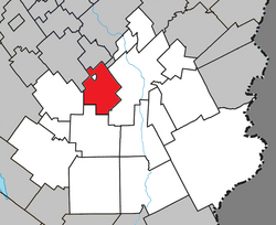
 Location within Beauce-Sartigan RCM. | |
| Coordinates: 46°04′N 70°48′W / 46.067°N 70.800°W[1] | |
| Country | |
| Province | |
| Region | Chaudière-Appalaches |
| RCM | Beauce-Sartigan |
| Constituted | January 4, 1894 |
| Government | |
| • Mayor | Marco Marois |
| • Federal riding | Beauce |
| • Prov. riding | Beauce-Sud |
| Area | |
| • Total | 86.90 km2 (33.55 sq mi) |
| • Land | 84.99 km2 (32.81 sq mi) |
| Population (2011)[3] | |
| • Total | 1,612 |
| • Density | 19.0/km2 (49/sq mi) |
| • Pop 2006-2011 | |
| • Dwellings | 735 |
| Time zone | UTC−5 (EST) |
| • Summer (DST) | UTC−4 (EDT) |
| Postal code(s) | |
| Area code(s) | 418 and 581 |
| Highways | |
| Website | www.saint benoitlabre.qc.ca |
Saint-Benoît-Labre is a municipality in the Municipalité régionale de comté de Beauce-Sartigan in Quebec, Canada. It is part of the Chaudière-Appalaches region and the population is 1,630 as of 2009. It is named after Benedict Joseph Labre.
In 2001 a group of Cistercian nuns moved from Saint-Romuald, Quebec to a newly constructed abbey in Saint-Benoît-Labre, where they make chocolate.
The territory of Saint-Benoît-Labre surrounds the village of Lac-Poulin.
References[edit]
- ^ "Banque de noms de lieux du Québec: Reference number 285906". toponymie.gouv.qc.ca (in French). Commission de toponymie du Québec.
- ^ a b "Répertoire des municipalités: Geographic code 29100". www.mamh.gouv.qc.ca (in French). Ministère des Affaires municipales et de l'Habitation.
- ^ a b "Saint-Benoît-Labre (Code 2429100) Census Profile". 2011 census. Government of Canada - Statistics Canada.
- Commission de toponymie du Québec
- Ministère des Affaires municipales, des Régions et de l'Occupation du territoire

