Oberaarhorn: Difference between revisions
Content deleted Content added
m fmt ib |
Swisstopo 23.04.2024 |
||
| (22 intermediate revisions by 15 users not shown) | |||
| Line 1: | Line 1: | ||
{{ |
{{short description|Mountain in Switzerland}} |
||
| ⚫ | |||
{{Infobox mountain |
|||
| ⚫ | |||
| ⚫ | |||
| Elevation = {{convert|3631|m|ft|0}} |
|||
| photo = Oberaarsee.jpg |
|||
| ⚫ | |||
| photo_caption = The Oberaarhorn (right) from the [[Oberaarsee]] (east side) |
|||
| ⚫ | |||
| elevation_m = 3631 |
|||
| Prominence= |
|||
| elevation_ref = |
|||
| ⚫ | |||
| prominence_m = 260 |
|||
| Topographic map = | Type = | Age = |
|||
| prominence_ref = <ref>Retrieved from the [[Swisstopo]] topographic maps. The key col is located west of the Altmann at 3,371 metres.</ref> |
|||
| First ascent = |
|||
| parent_peak = [[Finsteraarhorn]] |
|||
| Easiest route= |
|||
| ⚫ | |||
| map_caption = Location in Switzerland |
|||
| location = [[Valais]]/[[Canton of Bern|Bern]], [[Switzerland]] |
|||
| ⚫ | |||
| ⚫ | |||
| range_coordinates = |
|||
| ⚫ | |||
| type = |
|||
| age = |
|||
| first_ascent = |
|||
| easiest_route = |
|||
}} |
}} |
||
The '''Oberaarhorn''' is a [[mountain]] |
The '''Oberaarhorn''' is a [[mountain]] of the [[Bernese Alps]], located on the border between the Swiss cantons of [[Valais]] and [[Canton of Bern|Bern]]. Its summit (3,631 metres) is the tripoint between the basins of the [[Fiescher Glacier|Fiesch]] (Valais), [[Unteraar Glacier|Unteraar]] and [[Oberaar Glacier]] (Bern). |
||
{{Switzerland-geo-stub}} |
|||
==References== |
|||
{{reflist}} |
|||
==External links== |
|||
*[http://www.summitpost.org/mountain/rock/373248/oberaarhorn-3631m.html Oberaarhorn on Summitpost] |
|||
*[http://www.hikr.org/dir/Oberaarhorn_6130/ Oberaarhorn on Hikr] |
|||
[[Category:Mountains of the Alps]] |
[[Category:Mountains of the Alps]] |
||
[[Category:Alpine |
[[Category:Alpine three-thousanders]] |
||
[[Category:Mountains of Switzerland]] |
[[Category:Mountains of Switzerland]] |
||
[[Category:Mountains of the canton of Bern]] |
|||
[[Category:Mountains of Valais]] |
|||
[[Category:Bern–Valais border]] |
|||
{{valais-mountain-stub}} |
|||
{{bern-mountain-stub}} |
|||
Latest revision as of 15:00, 23 April 2024
| Oberaarhorn | |
|---|---|
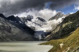
 The Oberaarhorn (right) from the Oberaarsee (east side) | |
| Highest point | |
| Elevation | 3,631 m (11,913 ft) |
| Prominence | 260 m (850 ft)[1] |
| Parent peak | Finsteraarhorn |
| Coordinates | 46°31′53″N 8°10′28″E / 46.53139°N 8.17444°E |
| Geography | |
| Location | Valais/Bern, Switzerland |
| Parent range | Bernese Alps |
The Oberaarhorn is a mountain of the Bernese Alps, located on the border between the Swiss cantons of Valais and Bern. Its summit (3,631 metres) is the tripoint between the basins of the Fiesch (Valais), Unteraar and Oberaar Glacier (Bern).
References[edit]
External links[edit]

