Teodelina: Difference between revisions
Content deleted Content added
categorization/tagging using AWB |
m rmv duplicate parm (via WP:JWB) |
||
| (27 intermediate revisions by 19 users not shown) | |||
| Line 1: | Line 1: | ||
{{Infobox settlement |
|||
'''Teodelina''' is situated in the [[Santa Fe Province]] of [[Argentina]]. |
|||
<!-- See Template:Infobox settlement for additional fields and descriptions --> |
|||
| name = Teodelina |
|||
| native_name = |
|||
| native_name_lang = <!-- ISO 639-2 code e.g. "fr" for French. If more than one, use {{lang}} instead --> |
|||
| settlement_type = |
|||
| image_skyline = Estación-Teodelina-FCGSM.jpg |
|||
| image_alt = |
|||
| image_caption = |
|||
| image_flag = |
|||
| flag_alt = |
|||
| image_seal = |
|||
| seal_alt = |
|||
| image_shield = |
|||
| shield_alt = |
|||
| nickname = |
|||
| motto = |
|||
| image_map = |
|||
| map_alt = |
|||
| map_caption = |
|||
| pushpin_map = |
|||
| pushpin_label_position = |
|||
| pushpin_map_alt = |
|||
| pushpin_map_caption = |
|||
| coordinates = |
|||
| coor_pinpoint = |
|||
| coordinates_footnotes = |
|||
| subdivision_type = Country |
|||
| subdivision_name = {{ARG}} |
|||
| subdivision_type1 = Province |
|||
| subdivision_name1 = [[Santa Fe Province|Santa Fe]] |
|||
| subdivision_type2 = Department |
|||
| subdivision_name2 = [[General López Department|General López]] |
|||
| subdivision_type3 = |
|||
| subdivision_name3 = |
|||
| established_title = |
|||
| established_date = December 19, 1894 |
|||
| founder = José Roberti |
|||
| seat_type = |
|||
| seat = |
|||
| government_footnotes = |
|||
| leader_party = |
|||
| leader_title = [[Communal President]] |
|||
| leader_name = [[Alejandro Luis Permingeat]] |
|||
| unit_pref = Metric<!-- or US or UK --> |
|||
<!-- ALL fields with measurements have automatic unit conversion --> |
|||
<!-- for references: use <ref> tags --> |
|||
| area_footnotes = |
|||
| area_urban_footnotes = <!-- <ref> </re> --> |
|||
| area_rural_footnotes = <!-- <ref> </re> --> |
|||
| area_metro_footnotes = <!-- <ref> </re> --> |
|||
| area_magnitude = <!-- <ref> </re> --> |
|||
| area_note = |
|||
| area_water_percent = |
|||
| area_rank = |
|||
| area_blank1_title = |
|||
| area_blank2_title = |
|||
<!-- square kilometers --> |
|||
| area_total_km2 = 713 |
|||
| area_land_km2 = |
|||
| area_water_km2 = |
|||
| area_urban_km2 = |
|||
| area_rural_km2 = |
|||
| area_metro_km2 = |
|||
| area_blank1_km2 = |
|||
| area_blank2_km2 = |
|||
<!-- hectares --> |
|||
| area_total_ha = |
|||
| area_land_ha = |
|||
| area_water_ha = |
|||
| area_urban_ha = |
|||
| area_rural_ha = |
|||
| area_metro_ha = |
|||
| area_blank1_ha = |
|||
| area_blank2_ha = |
|||
<!-- dunams used in Middle East articles only --> |
|||
| dunam_link = <!-- which dunam to link --> |
|||
| area_total_dunam = |
|||
| area_land_dunam = |
|||
| area_water_dunam = |
|||
| area_urban_dunam = |
|||
| area_rural_dunam = |
|||
| area_metro_dunam = |
|||
| area_blank1_dunam = |
|||
| area_blank2_dunam = |
|||
| length_km = |
|||
| width_km = |
|||
| dimensions_footnotes = |
|||
| elevation_footnotes = |
|||
| elevation_m = |
|||
| population_footnotes = |
|||
| population_total = 6095 |
|||
| population_as_of = |
|||
| population_density_km2 = auto |
|||
| population_demonym = Teodelinense |
|||
| population_note = |
|||
| timezone1 = |
|||
| utc_offset1 = |
|||
| timezone1_DST = |
|||
| utc_offset1_DST = |
|||
| postal_code_type = |
|||
| postal_code = S6009 |
|||
| area_code_type = |
|||
| area_code = |
|||
| iso_code = |
|||
| website = <!-- {{URL|example.com}} --> |
|||
| footnotes = |
|||
}} |
|||
'''Teodelina''' is a place situated in the [[General López Department]] of the [[Santa Fe Province]], Argentina. It is located 376 km from the [[Santa Fe, Argentina|Santa Fe city]], and 205 km from [[Rosario, Santa Fe|Rosario]]. It was established on December 19, 1894. |
|||
{{coord|-34.1897248|-61.5265274|format=dms|type:city|display=title}} |
{{coord|-34.1897248|-61.5265274|format=dms|type:city|display=title}} |
||
[[Category:Populated places in Santa Fe Province]] |
|||
{{Uncategorized|date=June 2011}} |
|||
{{SantaFeAR-geo-stub}} |
|||
Latest revision as of 01:28, 11 October 2020
Teodelina | |
|---|---|
 | |
| Country | |
| Province | Santa Fe |
| Department | General López |
| Founded by | José Roberti |
| Government | |
| • Communal President | Alejandro Luis Permingeat |
| Area | |
| • Total | 713 km2 (275 sq mi) |
| Population | |
| • Total | 6,095 |
| • Density | 8.5/km2 (22/sq mi) |
| Demonym | Teodelinense |
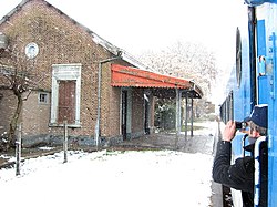
Teodelina is a place situated in the General López Department of the Santa Fe Province, Argentina. It is located 376 km from the Santa Fe city, and 205 km from Rosario. It was established on December 19, 1894.
34°11′23″S 61°31′35″W / 34.1897248°S 61.5265274°W
