
Vollenhove
Vollenhove | |
|---|---|
| Country | Netherlands |
| Province | Overijssel |
| Municipality | Steenwijkerland |
| Population (31 december 2006) | 4,121 |
| Major roads | N331 en N762 |
Vollenhove is a village in the Dutch province of Overijssel. It is located in the municipality of Steenwijkerland, southwest of Steenwijk. Until the Noordoostpolder was drained, it was located on the coast of the IJsselmeer.
Vollenhove received city rights in 1354. Later it was the main city in this region, that was formerly called Land van Vollenhove. Vollenhove was the summer residence of the bishop of Utrecht. he lived in the castle Toutenburg ,of which only some small ruins are left now. That is why quite some nobility moved to Vollenhove. They built their estates (Dutch: havezates) in the town, which was unique. Therefore Vollenhove was called the city of palaces. Like Blokzijl, peat transport to Holland by ship caused the small city to flourish during the 17th century.
Vollenhove was a separate municipality until 1973, when it became a part of Brederwiede. Between 1818 and 1942, the municipality was divided into two parts, Stad Vollenhove (the city) and Ambt Vollenhove (the countryside).[1]
-
 Vollenhove, monumental buildings
 -
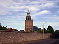 Vollenhove, church: Kleine of Lieve Vrouwkerk


References
52°41′N 5°57′E / 52.683°N 5.950°E
This Overijssel location article is a stub. You can help Wikipedia by expanding it. |