
Bugaksan: Difference between revisions
Content deleted Content added
more |
more |
||
| Line 38: | Line 38: | ||
|File:1953년_서울_남산에서_북악산_방향_파노라마_2.jpg |
|File:1953년_서울_남산에서_북악산_방향_파노라마_2.jpg |
||
|1953 view of the mountain, from [[Namsan (Seoul)|Namsan]]. The [[Japanese General Government Building, Seoul]] can be seen standing where Gyeongbokgung stood before |
|1953 view of the mountain, from [[Namsan (Seoul)|Namsan]]. The [[Japanese General Government Building, Seoul]] can be seen standing where Gyeongbokgung stood before |
||
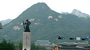
|File:Yi Sun-sin 3.jpg |
|||
|[[Statue of Admiral Yi Sun-sin]] and the mountain. The Blue House and the [[Statue of King Sejong (Gwanghwamun)|Statue of King Sejong]] can also be seen in the bottom. (2011) |
|||
|File:Bugaksan 20161116 03 (30900867212).jpg |
|File:Bugaksan 20161116 03 (30900867212).jpg |
||
|View from the mountain looking north (2016) |
|View from the mountain looking north (2016) |
||
Revision as of 11:50, 17 August 2023
| Bugaksan | |
|---|---|
 Bugaksan overlooking the former royal palace Gyeongbokgung (2008) | |
| Highest point | |
| Elevation | 342 m (1,122 ft) |
| Geography | |
 Bugaksan  Bugaksan Bugaksan (South Korea) | |
| Korean name | |
| Hangul | |
|---|---|
| Hanja | |
| Revised Romanization | Bugaksan |
| McCune–Reischauer | Pugaksan |
| Alternate name | |
| Hangul | 백악산 |
| Hanja | 白岳山 |
| Revised Romanization | Baegaksan |
| McCune–Reischauer | Paegaksan |
Bugaksan (Korean: 북악산) is a mountain north of the former royal palace Gyeongbokgung in Seoul. The mountain is also known as Baegaksan (백악산). Inwangsan, Naksan, and Namsan are the mountains that surround the Seoul Basin. The bedrock is granite and is about 342 meters (1,122 ft) high.[1]
Gallery
-
 Late 19th century photograph of Bugaksan and Gwanghwamun
 -
 1915 painting of Bugaksan by An Jung-sik
 -
 1953 view of the mountain, from Namsan. The Japanese General Government Building, Seoul can be seen standing where Gyeongbokgung stood before
 -
 Statue of Admiral Yi Sun-sin and the mountain. The Blue House and the Statue of King Sejong can also be seen in the bottom. (2011)
 -
 View from the mountain looking north (2016)


.jpg)
See also
References
37°36′22″N 126°59′00″E / 37.60611°N 126.98333°E
This South Korea location article is a stub. You can help Wikipedia by expanding it. |