
Bugaksan: Difference between revisions
more |
info |
||
| Line 31: | Line 31: | ||
|mr1 = Paegaksan |
|mr1 = Paegaksan |
||
}} |
}} |
||
'''Bugaksan''' ({{Korean|hangul=북악산}}) is a mountain north of |
'''Bugaksan''' ({{Korean|hangul=북악산}}) is a mountain in the north of [[Seoul]], South Korea. It famously overlooks former royal palace [[Gyeongbokgung]] as well as the former presidential residence the [[Blue House]]. [[Inwangsan]], [[Naksan]], and [[Namsan (Seoul)|Namsan]] are the mountains that surround the Seoul Basin.<ref name=":0" /><ref name=":1">{{cite web |title=북악산 |url=http://www.doopedia.co.kr/doopedia/master/master.do?_method=view&MAS_IDX=101013000845027 |accessdate=29 September 2014 |publisher=Doosan Encyclopedia |language=Korean}}</ref> It has a bedrock of [[granite]],<ref name=":1" /> and is about {{Convert|342|m|ft|sp=us}} high.<ref name=":0" /> |
||
The mountain has historically gone by a number of other names, including '''Baegaksan''' ({{Korean|hangul=백악산|labels=no}}). |
The mountain has historically gone by a number of other names, including '''Baegaksan''' ({{Korean|hangul=백악산|labels=no}}). |
||
== Names == |
== Names == |
||
Until the [[Joseon]] period, the mountain went by a variety of names, including Baegaksan, Myeonaksan ({{Korean|hangul=면악산|hanja=面岳山|labels=no}}), and Gonggeuksan ({{Korean|hangul=공극산|hanja=拱極山|labels=no}}). However, Baegaksan was the most popular name during the Joseon period.<ref name=":0">{{Cite web |title=북악산(北岳山) |trans-title=Bugaksan |url=https://encykorea.aks.ac.kr/ |access-date=2023-08-17 |website=[[Encyclopedia of Korean Culture]] |language=ko}}</ref> The name "Bugaksan" means "north mountain".<ref>{{Cite web |title=北岳山 |url=https://hanja.dict.naver.com/#/entry/ccko/fbea9c12c30d46ebbd5000812d912da2 |access-date=2023-08-17 |website=Naver Hanja Dictionary |language=ko}}</ref> |
Until the [[Joseon]] period, the mountain went by a variety of names, including Baegaksan, Myeonaksan ({{Korean|hangul=면악산|hanja=面岳山|labels=no}}), and Gonggeuksan ({{Korean|hangul=공극산|hanja=拱極山|labels=no}}). However, Baegaksan was the most popular name during the Joseon period.<ref name=":0">{{Cite web |last=김 |first=주환 |title=북악산(北岳山) |trans-title=Bugaksan |url=https://encykorea.aks.ac.kr/ |access-date=2023-08-17 |website=[[Encyclopedia of Korean Culture]] |language=ko}}</ref> The name "Bugaksan" means "north mountain".<ref>{{Cite web |title=北岳山 |url=https://hanja.dict.naver.com/#/entry/ccko/fbea9c12c30d46ebbd5000812d912da2 |access-date=2023-08-17 |website=Naver Hanja Dictionary |language=ko}}</ref> |
||
== Description == |
== Description == |
||
The mountain is part of a southern range of mountains connected to [[Bukhansan]], the highest mountain in Seoul.<ref name=":0" /> |
The mountain is part of a southern range of mountains connected to [[Bukhansan]], the highest mountain in Seoul.<ref name=":0" /> |
||
There are 208 species of plants on the mountain, including 81 species of trees.<ref name=":0" /> |
|||
The [[Cheonggyecheon]] stream that flows through Seoul originates from the mountain. In November 2005, the [[Jongno District]] government investigated the source of the river, and found that it was a mineral water spring about {{Convert|150|m|ft}} from a statue of police officer {{Ill|Choi Gyu-sik|ko|최규식 (경찰관)}}.<ref name=":0" /> |
|||
== Gallery == |
== Gallery == |
||
Revision as of 12:09, 17 August 2023
| Bugaksan | |
|---|---|
 Bugaksan overlooking the former royal palace Gyeongbokgung (2008) | |
| Highest point | |
| Elevation | 342 m (1,122 ft) |
| Naming | |
| Etymology | North mountain |
| Geography | |
 Bugaksan  Bugaksan | |
| Country | South Korea |
| City | Seoul |
| Korean name | |
| Hangul | |
|---|---|
| Hanja | |
| Revised Romanization | Bugaksan |
| McCune–Reischauer | Pugaksan |
| Alternate name | |
| Hangul | 백악산 |
| Hanja | 白岳山 |
| Revised Romanization | Baegaksan |
| McCune–Reischauer | Paegaksan |
Bugaksan (Korean: 북악산) is a mountain in the north of Seoul, South Korea. It famously overlooks former royal palace Gyeongbokgung as well as the former presidential residence the Blue House. Inwangsan, Naksan, and Namsan are the mountains that surround the Seoul Basin.[1][2] It has a bedrock of granite,[2] and is about 342 meters (1,122 ft) high.[1]
The mountain has historically gone by a number of other names, including Baegaksan (백악산).
Names
Until the Joseon period, the mountain went by a variety of names, including Baegaksan, Myeonaksan (면악산; 面岳山), and Gonggeuksan (공극산; 拱極山). However, Baegaksan was the most popular name during the Joseon period.[1] The name "Bugaksan" means "north mountain".[3]
Description
The mountain is part of a southern range of mountains connected to Bukhansan, the highest mountain in Seoul.[1]
There are 208 species of plants on the mountain, including 81 species of trees.[1]
The Cheonggyecheon stream that flows through Seoul originates from the mountain. In November 2005, the Jongno District government investigated the source of the river, and found that it was a mineral water spring about 150 metres (490 ft) from a statue of police officer Choi Gyu-sik.[1]
Gallery
-
 Late 19th century photograph of Bugaksan and Gwanghwamun
 -
 1915 painting of Bugaksan by An Jung-sik
 -
 1953 view of the mountain, from Namsan. The Japanese General Government Building can be seen standing where Gyeongbokgung stood before
 -
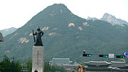 Statue of Admiral Yi Sun-sin and the mountain. The Blue House and the Statue of King Sejong can also be seen in the bottom. (2011)
 -
 View from the mountain looking north (2016)


.jpg)
See also
References
37°36′22″N 126°59′00″E / 37.60611°N 126.98333°E
This South Korea location article is a stub. You can help Wikipedia by expanding it. |