
Helechawa, Kentucky
Helechawa | |
|---|---|
 Helechawa Location within the state of Kentucky  Helechawa Helechawa (the United States) | |
| Coordinates: 37°45′57″N 83°20′22″W / 37.76583°N 83.33944°W | |
| Country | United States |
| State | Kentucky |
| County | Wolfe |
| Elevation | 1,001 ft (305 m) |
| Time zone | UTC-5 (Eastern (EST)) |
| • Summer (DST) | UTC-4 (EST) |
| ZIP codes | 41334 |
| GNIS feature ID | 508219[1] |
Helechawa is an unincorporated community in Wolfe County, Kentucky, United States.
The town of Helechawa was established in 1901 along the route of the Ohio and Kentucky Railroad. The president of the railway coined the name from that of his daughter, Helen Chase Walbridge.[2] Its post office [3] has since closed.
References
- ^ U.S. Geological Survey Geographic Names Information System: Helechawa, Kentucky
- ^ Rennick, Robert M. (1987). Kentucky Place Names. University Press of Kentucky. pp. 136–137. ISBN 0813126312. Retrieved 2013-04-28.
- ^ U.S. Geological Survey Geographic Names Information System: Helechawa KY post office
Municipalities and communities of Wolfe County, Kentucky, United States | ||
|---|---|---|
| City | 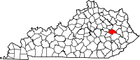 | |
| CDP | ||
| Other unincorporated communities | ||
This Wolfe County, Kentucky state location article is a stub. You can help Wikipedia by expanding it. |