Hoyoux: Difference between revisions
Content deleted Content added
mNo edit summary |
m Repair duplicate template arguments |
||
| Line 10: | Line 10: | ||
| subdivision_type1 = Country |
| subdivision_type1 = Country |
||
| subdivision_name1 = [[Belgium]] |
| subdivision_name1 = [[Belgium]] |
||
| progression = |
|||
| length = {{convert|28|km|mi|abbr=on}} |
| length = {{convert|28|km|mi|abbr=on}} |
||
| source1_elevation = |
| source1_elevation = |
||
Revision as of 14:16, 22 November 2021
You can help expand this article with text translated from the corresponding article in Dutch. (February 2010) Click [show] for important translation instructions.
|
| Hoyoux | |
|---|---|
 | |
| Location | |
| Country | Belgium |
| Physical characteristics | |
| Source | |
| • location | Liège Province |
| Mouth | |
• location | Meuse |
• coordinates | 50°31′11″N 5°14′18″E / 50.5197°N 5.2383°E |
| Length | 28 km (17 mi) |
| Basin features | |
| Progression | Meuse→ North Sea |

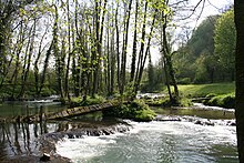
The Hoyoux (French pronunciation: [ɔju]) is a river of Belgium, a right tributary of the Meuse. It flows for 28 kilometres (17 mi) through the province of Liège in the northern-central part of the country. It flows into the Meuse in Huy.
