Malibu Rapids (British Columbia): Difference between revisions
m orthographic |
m clean up, References after punctuation per WP:REFPUNC and WP:PAIC using AWB (8748) |
||
| Line 22: | Line 22: | ||
| frozen = |
| frozen = |
||
}} |
}} |
||
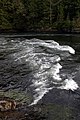
The '''Malibu Rapids''' forms the entrance to [[Princess Louisa Inlet]] and is also connected to the [[Jervis Inlet]]. The [[tidal flow]] of both inlets pass through this narrow and shallow passage that creates a fast moving (approximately {{convert|9|kn|km/h|abbr=on|disp=or}}) and strong tidal rapids during the peak flows. At [[Slack water|slack tide]], the entrance is virtually flat calm similar to the |
The '''Malibu Rapids''' forms the entrance to [[Princess Louisa Inlet]] and is also connected to the [[Jervis Inlet]]. The [[tidal flow]] of both inlets pass through this narrow and shallow passage that creates a fast moving (approximately {{convert|9|kn|km/h|abbr=on|disp=or}}) and strong tidal rapids during the peak flows. At [[Slack water|slack tide]], the entrance is virtually flat calm similar to the |
||
| Line 28: | Line 27: | ||
The way to determine the direction of the tidal flow at the narrows is to observe the direction in which the [[tide]] is flowing. If the [[tide|tidal flow]] is heading toward the |
The way to determine the direction of the tidal flow at the narrows is to observe the direction in which the [[tide]] is flowing. If the [[tide|tidal flow]] is heading toward the |
||
[[Jervis Inlet]] then the tide is going out [[Tide|(low tide)]]. But if the flow is moving toward [[Princess Louisa Inlet]] the [[tide]] it is coming in [[Tide|(high tide)]]<ref>Hitz, |
[[Jervis Inlet]] then the tide is going out [[Tide|(low tide)]]. But if the flow is moving toward [[Princess Louisa Inlet]] the [[tide]] it is coming in [[Tide|(high tide)]].<ref>Hitz, |
||
Charles W.(2003). ''Through the Rapids - The History of Princess Louisa Inlet'', p.14-15. [http://www.sitka2.com Sitka 2 Publishing]., Kirkland, WA. ISBN 0-9720255-0-2.</ref> |
Charles W.(2003). ''Through the Rapids - The History of Princess Louisa Inlet'', p.14-15. [http://www.sitka2.com Sitka 2 Publishing]., Kirkland, WA. ISBN 0-9720255-0-2.</ref> |
||
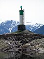
The entrance is large enough to allow marine traffic through. The narrow passage is defined by [[Malibu Isle]] and a [[Lateral mark| |
The entrance is large enough to allow marine traffic through. The narrow passage is defined by [[Malibu Isle]] and a [[Lateral mark|System B type Lateral navigation buoy]] on the [[Jervis Inlet]] side and [[Malibu Club in Canada|Malibu]] and the mainland on the [[Princess Louisa Inlet]] side. |
||
| ⚫ | |||
| ⚫ | |||
==External links== |
==External links== |
||
| Line 39: | Line 41: | ||
*[http://www.mobilegeographics.com:81/locations/5098.html Tides at Malibu]* |
*[http://www.mobilegeographics.com:81/locations/5098.html Tides at Malibu]* |
||
*[http://www.youtube.com/user/chaz8993 Princess Louisa Inlet and Malibu Videos] |
*[http://www.youtube.com/user/chaz8993 Princess Louisa Inlet and Malibu Videos] |
||
| ⚫ | |||
| ⚫ | |||
== Gallery == |
== Gallery == |
||
Revision as of 21:15, 5 December 2012
| Malibu Rapids | |
|---|---|
 Map of the Malibu Rapids | |
| Location | South end of Princess Louisa Inlet, New Westminster Land District |
| Coordinates | 50°9′50.91″N 123°50′58.97″W / 50.1641417°N 123.8497139°W |
| Basin countries | British Columbia, Canada |
The Malibu Rapids forms the entrance to Princess Louisa Inlet and is also connected to the Jervis Inlet. The tidal flow of both inlets pass through this narrow and shallow passage that creates a fast moving (approximately 9 kn or 17 km/h) and strong tidal rapids during the peak flows. At slack tide, the entrance is virtually flat calm similar to the Skookumchuck Narrows near the entrance of the Jervis Inlet.
The way to determine the direction of the tidal flow at the narrows is to observe the direction in which the tide is flowing. If the tidal flow is heading toward the Jervis Inlet then the tide is going out (low tide). But if the flow is moving toward Princess Louisa Inlet the tide it is coming in (high tide).[1]
The entrance is large enough to allow marine traffic through. The narrow passage is defined by Malibu Isle and a System B type Lateral navigation buoy on the Jervis Inlet side and Malibu and the mainland on the Princess Louisa Inlet side.
References
- ^ Hitz, Charles W.(2003). Through the Rapids - The History of Princess Louisa Inlet, p.14-15. Sitka 2 Publishing., Kirkland, WA. ISBN 0-9720255-0-2.
External links
- "Malibu Rapids". BC Geographical Names.
- Malibu Club Web Site
- BCGNIS Geographical Geographical Name Detail for the Malibu Rapids
- Tides at Malibu*
- Princess Louisa Inlet and Malibu Videos
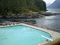
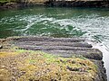
Gallery
- Malibu Rapids Gallery
-

-
-
-

-
-

-