Pic de Médécourbe: Difference between revisions
Content deleted Content added
| Line 33: | Line 33: | ||
[[Category:Mountains of the Pyrenees]] |
[[Category:Mountains of the Pyrenees]] |
||
[[Category:Mountains of Andorra]] |
[[Category:Mountains of Andorra]] |
||
[[Category:Mountains of |
[[Category:Mountains of Occitania (administrative region)]] |
||
[[Category:Mountains of Catalonia]] |
[[Category:Mountains of Catalonia]] |
||
[[Category:International mountains of Europe]] |
[[Category:International mountains of Europe]] |
||
Revision as of 21:34, 8 February 2022
| Pic de Médécourbe | |
|---|---|
| Pic de Medacorba | |
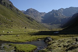
 The Vicdessos valley looking towards Pic de Médécourbe and Col de Bareytes (2859m) in the background | |
| Highest point | |
| Elevation | 2,914 m (9,560 ft)[1] |
| Coordinates | 42°36′07″N 01°26′32″E / 42.60194°N 1.44222°E |
| Geography | |
| Location | Andorra – France – Spain border |
| Parent range | Pyrenees |
Pic de Médécourbe (Catalan: Pic de Medacorba) is a mountain in Europe that sits on the western tripoint boundary of Andorra, France and Spain. It is 2,914 metres (9,560 ft) tall. It overlooks Étang de Soulcem, a large artificial lake used for hydroelectricity, and the Vicdessos valley.[1]
There is also an eastern tripoint of Andorra, France, and Spain approximately 6 km south of Pas de la Casa.[1]
References
Categories:
- Mountains of the Pyrenees
- Mountains of Andorra
- Mountains of Occitania (administrative region)
- Mountains of Catalonia
- International mountains of Europe
- Andorra–France border
- Andorra–Spain border
- France–Spain border
- Border tripoints
- Two-thousanders of Andorra
- Two-thousanders of France
- Landforms of Ariège (department)
- Andorra geography stubs
- Ariège (department) geography stubs
- Spain geography stubs

