Pic de Médécourbe: Difference between revisions
Content deleted Content added
m Date maintenance tags and general fixes: build 401: |
m tidy Infobox mountain using AWB |
||
| Line 1: | Line 1: | ||
{{Unreferenced|date=January 2010}} |
{{Unreferenced|date=January 2010}} |
||
{{Infobox mountain |
{{Infobox mountain |
||
| |
| name = Pic de Médécourbe |
||
| |
| photo = Col de Bareytes et crete de Médécourbe.JPG |
||
| |
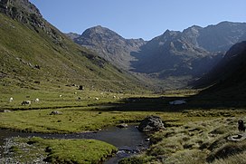
| photo_caption = The Soulcem valley looking towards Pic de Médécourbe and Col de Bareytes (2859m) in the background |
||
| |
| elevation_m = 2914 |
||
| elevation_ref = |
|||
| ⚫ | |||
| prominence = |
|||
| Range = [[Pyrenees]] |
|||
| |
| map = Andorra |
||
| ⚫ | |||
| Topographic map = |
|||
| |
| map_size = 200 |
||
| |
| label_position = right |
||
| |
| listing = |
||
| ⚫ | |||
| Easiest route = |
|||
| |
| range = [[Pyrenees]] |
||
| lat_d = 42 | lat_m = 36 | lat_s = 7 | lat_NS = N |
|||
| Translation = |
|||
| long_d = 1 | long_m = 26 | long_s = 32 | long_EW = E |
|||
| Language = |
|||
| |
| coordinates_ref = |
||
| topo = |
|||
| pushpin_map = Andorra |
|||
| type = |
|||
| pushpin_label_position = right |
|||
| age = |
|||
| ⚫ | |||
| first_ascent = |
|||
| pushpin_mapsize = 200 |
|||
| easiest_route = |
|||
| coordinates_ref = |
|||
| latd=42 |latm=36 |lats=7|latNS=N |
|||
| longd=1 |longm=26 |longs=32 |longEW=E |
|||
}} |
}} |
||
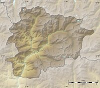
'''Pic de Médécourbe''' (Catalan: '''''Pic de Medacorba''''') is a mountain in [[Europe]] that sits on the western [[tripoint]] boundary of [[Andorra]], [[France]] and [[Spain]]. It is {{convert|2914|m|ft|0}} tall, with the highest part of the peak being in France.{{Dubious|This does not make sense because the peak is the tripoint.|date=February 2010}} |
'''Pic de Médécourbe''' (Catalan: '''''Pic de Medacorba''''') is a mountain in [[Europe]] that sits on the western [[tripoint]] boundary of [[Andorra]], [[France]] and [[Spain]]. It is {{convert|2914|m|ft|0}} tall, with the highest part of the peak being in France.{{Dubious|This does not make sense because the peak is the tripoint.|date=February 2010}} |
||
| Line 37: | Line 36: | ||
[[Category:Mountains of Catalonia]] |
[[Category:Mountains of Catalonia]] |
||
[[Category:Border tripoints]] |
[[Category:Border tripoints]] |
||
{{Andorra-geo-stub}} |
{{Andorra-geo-stub}} |
||
Revision as of 11:58, 15 April 2010
| Pic de Médécourbe | |
|---|---|
 The Soulcem valley looking towards Pic de Médécourbe and Col de Bareytes (2859m) in the background | |
| Highest point | |
| Elevation | 2,914 m (9,560 ft) |
| Geography | |
| Location | |
| Parent range | Pyrenees |
Pic de Médécourbe (Catalan: Pic de Medacorba) is a mountain in Europe that sits on the western tripoint boundary of Andorra, France and Spain. It is 2,914 metres (9,560 ft) tall, with the highest part of the peak being in France.[dubious ]

