Pic de Médécourbe: Difference between revisions
Content deleted Content added
mNo edit summary |
m Replace per TFD outcome |
||
| Line 24: | Line 24: | ||
}} |
}} |
||
'''Pic de Médécourbe''' (Catalan: '''''Pic de Medacorba''''') is a mountain in [[Europe]] that sits on the western [[tripoint]] boundary of [[Andorra]], [[France]] and [[Spain]]. It is {{convert|2914|m|ft|0}} tall. It overlooks [[Étang de Soulcem]], a large artificial lake used for hydroelectricity, and the [[:fr:Vicdessos (rivière)|Vicdessos valley]].<ref name="ada">Govern d'Andorra (1991). ''Atlas d'Andorra'', map of northwestern Andorra, p.20. {{ca}}</ref> |
'''Pic de Médécourbe''' (Catalan: '''''Pic de Medacorba''''') is a mountain in [[Europe]] that sits on the western [[tripoint]] boundary of [[Andorra]], [[France]] and [[Spain]]. It is {{convert|2914|m|ft|0}} tall. It overlooks [[Étang de Soulcem]], a large artificial lake used for hydroelectricity, and the [[:fr:Vicdessos (rivière)|Vicdessos valley]].<ref name="ada">Govern d'Andorra (1991). ''Atlas d'Andorra'', map of northwestern Andorra, p.20. {{ca icon}}</ref> |
||
There is also an eastern tripoint of Andorra, France, and Spain approximately 6 km south of [[Pas de la Casa]].<ref name="ada"/> |
There is also an eastern tripoint of Andorra, France, and Spain approximately 6 km south of [[Pas de la Casa]].<ref name="ada"/> |
||
Revision as of 03:09, 30 September 2013
| Pic de Médécourbe | |
|---|---|
| Pic de Medacorba | |
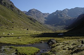
 The Vicdessos valley looking towards Pic de Médécourbe and Col de Bareytes (2859m) in the background | |
| Highest point | |
| Elevation | 2,914 m (9,560 ft)[1] |
| Geography | |
| Location | Andorra – France – Spain border |
| Parent range | Pyrenees |
Pic de Médécourbe (Catalan: Pic de Medacorba) is a mountain in Europe that sits on the western tripoint boundary of Andorra, France and Spain. It is 2,914 metres (9,560 ft) tall. It overlooks Étang de Soulcem, a large artificial lake used for hydroelectricity, and the Vicdessos valley.[1]
There is also an eastern tripoint of Andorra, France, and Spain approximately 6 km south of Pas de la Casa.[1]
References
- ^ a b c Govern d'Andorra (1991). Atlas d'Andorra, map of northwestern Andorra, p.20. Template:Ca icon

