
Āraiši Archaeological Park


The Archaeological Park Āraiši is part of the Gauja National Park and is a National Historical Museum of Latvia .
Coordinates: 57 ° 25 ′ 13.5 ″ N , 25 ° 28 ′ 16.3 ″ E

location
The village of Āraiši with the open-air museum is located in the Latvian district of Amata 7 km south of Cesis , 30 km northeast of Sigulda and 81 km northeast of Riga .
Archaeological Park
The museum consists of 3 parts:
- Girl Island with the reconstructions of settlements from the Stone, Bronze and Younger Iron Ages
- Āraiši island settlement with a Latgalian castle from the 9th - 10th centuries
- Ruins of the Arrasch order castle of the Livonian Order (14th - 17th centuries)
The special feature of the facility is the concentration of archaeological sites from the Stone Age to the modern age over a time frame of approx. 10,000 years on a relatively small area.
The facility is well equipped with information and description boards in Latvian, English, German and Russian.
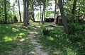
Girls Island
The moor island in the south of the facility is accessible via a boardwalk. Reconstructions of dwellings and everyday objects are shown that document the Stone, Bronze and Iron Ages. On the island itself, only individual finds from these archaeological stages were found such as stone axes, flint tools, ceramic shards, etc. The reconstructed find complexes of the dwelling objects come from the Latvian sites of Celmi (Stone Age - 8500 to 4500 BC) and Brikuli and Mükukalns (Bronze to Iron Age - 4500 to 1500 BC and 1500 BC to 0) and were reconstructed and shown here on an occupied settlement site. The branch and reed huts of the Stone Age in different occupied variants as well as fireplaces and a dugout canoe are informative. The block buildings with thatched roofs from the Bronze and Iron Ages with clay ovens, fishing gear, ceramics, other household appliances and tools follow.

Boardwalk to the girl island
Stone Age accommodation in variants

Bronze Age house

Iron Age House (damaged)


Āraiši island settlement
The pile-dwelling settlement on a sandbank of Lake Āraišu has extensive archaeological evidence. It was not only attributed to the archaeological finds, but also dendrologically to a time from 830 and the Latgals . The Baltic Slavs were a minority as an intermediate form between the East and West Slavs. The Latgals mentioned here are the ethnic group recorded in Latvian history during the Viking Age. The island settlement was first excavated selectively in 1876 by Jacob Karl Georg von Sievers. He relied on old legends. In 1877 he got help from the then famous researcher Rudolf Virchow from Berlin. But more than the determination of the existence of an early medieval settlement was not possible at the time. So it was only possible for the Latvian Janis Apals from 1965 to 1969 and 1975 to 1979 to explore the entire island settlement in extensive and complex excavations. For this purpose, the water level of the lake was lowered and the island was polded. The settlement, which is over 1000 years old, has been completely excavated and has been very well preserved. The wooden platform and up to five layers of beams in the building were discovered, along with the fallen components such as roof structures, etc. In addition to the components, over 3,500 individual finds of tools, ceramics, household items, jewelry, weapons and other artefacts were made. The preservation of the components from five successive building layers of the one century existing settlement allowed a professional reconstruction of the entire island settlement. An experimental building was built on the mainland in 1981 to check building methods and materials. The replica on the island began in 1985 and has not yet been completed.
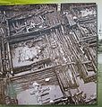
Excavation photo from 1967 (information board)
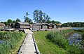
Footbridge to the island settlement Āraiši

Houses of the island settlement on the platform

Inside of the hut with clay oven


Ruin of the Ordensburg
The order castle Arrasch (Latvian Āraiši) of the Livonian or Livonian order of knights was first mentioned in 1410. It is located on the eastern part of the peninsula in Lake Āraišu. The outer bailey settlement was in the western part of the peninsula, but is now only barely visible. Until 1561 it was the seat of the castle district of Arrasch of the Livonian Order State and a neighboring castle of the order master residence Burg Wenden (Latvian: Cesis). From 1561 to 1629 it was the administrative center of the official property of the Polish kings. As a result, it fell into disrepair.
The castle itself had a floor plan of 81 by 81 meters, the walls were 2 meters thick. There was a ditch between the castle and the outer bailey, it was 125 m long, 20 m wide and 6 m deep. It is dry today. The moat was bridged by a drawbridge from a guardhouse (10 × 7.85 m) to the settlement. The excavations from 1972 to 1974 and 1981 to 1992 uncovered not only the foundation walls but also residential and commercial installations, they documented the medieval German castle building traditions. In the many hundreds of individual finds, however, artifacts were found that could be assigned to the local (Latvian) castle people.

Access to the Ordensburg with guard house (drawbridge) and moat

Interior of the order castle with fixtures

Excavation photos of the castle in 1974 with finds (information board)

Castle model with excavated fixtures


Environment of the plant
In addition to these three archaeological objects, the Āraiši Church from 1225 to the north and the Liepina burial ground on the eastern side of the Āraišu Lake are important for the Āraiši Archaeological Park. To the west, 1.5 km away, there is still a well-preserved windmill to be visited. The facility can be visited from May to November, around 30,000 tourists visit this museum each year, 10% of them foreigners.
literature
- Janis Apals, Āraiši island settlement - reconstruction of a 9th century dwelling, Cesu Rajons - Latvia
- annotation
Further evidence can be found on the extensive information boards, also in German. These have been recorded in photos and partially used.
See also
Web links
- Homepage of the national park (Latvian / English)