Bandelier National Monument
| Bandelier National Monument | ||
|---|---|---|
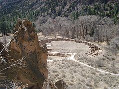
| Pueblo Tyuonyi in the Frijoles Gorge | ||
|
|
||
| Location: | New Mexico , United States | |
| Next city: | Santa Fe (New Mexico) | |
| Surface: | 136.3 km² | |
| Founding: | February 11, 1916 | |
| Visitors: | 174,073 (2015) | |
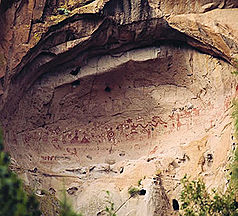
| Cave paintings in the hinterland | ||
The Bandelier National Monument is both a memorial and a nature reserve of the type of a national monument in northern New Mexico , USA with an area of approximately 136 km². More than two thirds of it (95 km²) stand as Bandelier Wilderness under the further protection of a wilderness area . The main attraction of the National Monument is the Frijoles Gorge. It was settled by the forerunners of the Pueblo culture between 1100 and 1550 . There are more than 1000 settlements in the area, in the largest Tyuoyi Pueblo you can find community house and ceremonial cave ( Kiva) see. To the south is the Painted Cove , a cave with prehistoric petroglyphs .
The area has been a national monument since 1916 and was named after the anthropologist Adolph Bandelier . It was closed to the public for several years during World War II, when some scientists from the Manhattan Project from the nearby Los Alamos National Laboratory lived here. The wilderness reserve was added in October 1976.
Web links
- National Park Service: Bandelier National Monument (official site; English)


