
Besenbinderhof

The Besenbinderhof is a street in the Hamburg district of St. Georg and is best known as the address of the trade union building that is also known. While the name today only refers to the residential street directly in front of the trade union building, before 1962 it also referred to Kurt-Schumacher- Allee , which ran further north .
location
The street is located in Hamburg's St. Georg district south of the main train station and runs largely parallel to Kurt-Schumacher-Allee. Access is possible via this avenue and the Nagelsweg .
history
In the 17th century there was an inn of this name on the road. In addition, gardens and summer houses of wealthy Hamburg merchants were located here, including the garden that Barthold Heinrich Brockes described several times in his poems. Between 1817 and 1890 there was an amusement park on the grounds of the inn.
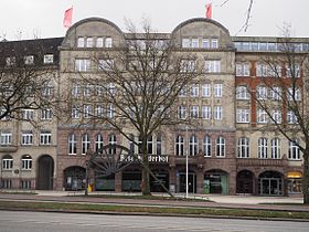
Here was 1903-1913 as the Besenbinderhof called the union hall of the General German Trade Union Confederation built (now number 56 to 60), which in 1906 completed part of August Bebel as a third attraction next to the Central Station and the City Hall called. Next to this building was the main administration building of the large purchasing company Deutscher Consumvereine GEG (No. 52), as well as the main administration of the union public welfare insurance (today Generali , No. 43). The Hamburg-Mitte Health Department (No. 41) established by Hermann Höger in 1926 rounds off the ensemble to the east.

Health Department from 1926
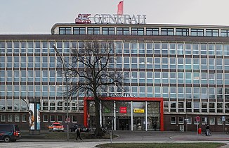
Former House of Public Welfare, now Generali

Former GEG administration building from 1906/07
Trade union building
(east wing) from 1913


Web links
Individual evidence
- ↑ City map from 1886, grid square E 4. In: www.archiv-hhnv.de. Retrieved December 10, 2016 .
- ↑ Horst Beckershaus: The Hamburg street names: where they come from and what they mean. Completely from A to Z . 6th, updated edition. Hamburg 2011, ISBN 978-3-86393-009-7 , pp. 219 ( amazon.de [accessed on August 27, 2018]).
- ^ Franklin Kopitzsch , Daniel Tilgner (ed.): Hamburg Lexikon. 4th, updated and expanded special edition. Ellert & Richter, Hamburg 2010, ISBN 978-3-8319-0373-3 , p. 86.
Coordinates: 53 ° 33 ′ 4.7 ″ N , 10 ° 0 ′ 49.1 ″ E