Biwasee Canal
The Biwasee Canal ( Japanese 琵琶湖 疏水 , Biwako Sosui or 山 科 疏水 Yamashina Sosui ) is a system of canals in Japan that was started in the Meiji period to serve several purposes. It supplies the city of Kyōto with water, previously also served as a waterway to transport freight and passengers and made it possible to operate a hydropower plant in Kyoto from 1895 , the first publicly built in Japan.
The canal system begins at Lake Biwa in the city of Ōtsu on Mihogasaki. The first canal begins at the lake ( 35 ° 0 ′ 48.8 ″ N , 135 ° 51 ′ 35.7 ″ E ), runs under the Kannon Hall of the Mii-dera through a tunnel under the Nagarayama, then runs in the district Yamashina above ground, before entering the Okayama Tunnel and finally ending in the Kyoto district of Sakyō ( 35 ° 0 ′ 56.2 ″ N , 135 ° 46 ′ 17.3 ″ E ), where it reaches the Kamo-gawa River . From Lake Biwas to Kamo-gawa in Kyoto, the length of the route is around 18 km.
Idea and planning
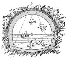
Already in the Edo period the construction of a canal between Lake Biwa and Kyoto was thought of, but it was not until the Meiji period that the incumbent governor of Kyoto , Kitagaki Kunimichi ( 北垣 国 道 ; 1836–1916), decided to put this idea into practice to implement. Kyōto suffered at the time from the emperor's departure, whose permanent residence was now in Tōkyō. Kitagaki, who considered the canal necessary as part of his 100-year development plan for Kyoto, commissioned the young engineer Tanabe Sakurō ( 田 邉 朔 郎 ; 1861-1944) in 1884 with the design and construction management. After a year of planning, construction began in 1885, which was associated with many difficulties and was only completed in 1890. The construction of the tunnel, the first of its kind in Japan, under the mountains surrounding Lake Biwa, began with a shaft in the middle of the route, from which the tunnel was built in both directions.
In order to be able to use the canal for shipping, it was necessary to cope with the exit height of 35 m above the level of Kyoto. It was decided to build an inclined elevator ( イ ン ク ラ イ ン , Inkurain , from English incline ) for this purpose , on which the boats were transported on wagons that ran on rails. The wagons were moved first with water wheels, then with machines.
At the upper beginning of the inclined elevator, the water flow forked: part of the water was led directly into the city, another part of the water was led to the north, where it passed through with the help of a canal bridge built with brick, called Suirokaku ( 水路 閣 ) cutting the area of Nanzen-ji as far as the northern part of Kyoto. This canal bridge has been preserved, it is 93 m long, has a width of 4 m, with a width for the water flow of about 2.4 m.
Later extensions
A second canal dates from 1912. It begins at the Biwasee a little north of the first canal and runs almost entirely below the surface of the earth and is primarily used to supply drinking water. A third canal was completed in 1999. It begins next to the 2nd canal and is designed as an additional tunnel under the mountains on Lake Biwa.
The canal today
The shipping has long been stopped, the inclined elevator can be used. The generation of electricity through hydropower also no longer plays a role. - In August 1989 the Biwasee Canal Museum ( 琵琶湖 疏水 記念 館 , Biwako Sosui Kinenkan ) was opened to mark the canal's centenary. After a renovation, it was reopened in 2009.
In 1996 the canal was registered as a national historical monument.
literature
- Kyoto-fu rekishi isan kenkyukai (ed.): Kyoto-fu no rekishi sampo (chu). Yamakawa Shuppan, 2011. ISBN 978-4-634-24726-0 . Pp. 18 to 19 and pp. 268 to 271.
- Shiga-ken kotogakko rekishi sampo kenkyukai (ed.): Shiga-ken no rekishi sampo (jo). Yamakawa Shuppan, 1990. ISBN 978-4-634-29250-5 . P. 71.


