Burrard Street Bridge
Coordinates: 49 ° 16'31 " N , 123 ° 8'14" W.
| Burrard Street Bridge | ||
|---|---|---|
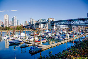
| The Burrard Street Bridge seen from Fisherman's Wharf. | ||
| use | Road bridge (six lanes) with footpath and bike path | |
| Convicted | Burrard Street | |
| Crossing of | False Creek | |
| place | Vancouver | |
| construction | Truss bridge | |
| overall length | 836.08 | |
| building-costs | C $ 3 million | |
| start of building | December 8, 1930 | |
| opening | July 1, 1932 | |
| location | ||
|
|
||
| The northern pylon of the middle section | ||
The Burrard Street Bridge , sometimes just Burrard Bridge , is a steel truss bridge in the Canadian province of British Columbia . It spans False Creek and connects the two districts of Kitsilano and West End of Vancouver .
The bridge is very busy and the oldest of the three bridges over False Creek. On an annual average, around 55,000 vehicles, 2,800 cyclists and 2,100 pedestrians cross the bridge every day.
history
Originally, the bridge connected Burrard Street on the north bank with Cedar Street on the south bank. However, shortly after the bridge was opened, the street name was continued across the bridge and the name Cedar Street disappeared.
Building
The bridge consists of several segments. The middle part of the truss spans the fairway of False Creek, while the adjoining northern truss segment only spans the bank area. The half-timbered segment adjoining the central part to the south runs over a marina. The two sections adjoining the middle part are additionally supported in the middle by supports. While at the northern end the driveway is more or less direct to the bridge, a longer ramp has to be used for the driveway at the southern end.
The middle section is supported by a stone-clad metal pylon. Above the road, this stone cladding was elaborately executed in the Art Deco style. The motto of the city of Vancouver ("By sea and land we prosper") is clearly recognizable - also for the motorists; it is still in its earlier form without the addition "air".
Problem of cyclists - pedestrians
During the planning and construction of the bridge, the footpaths and cycle paths next to the roadways were designed according to the conditions and forecasts at the time. The paths next to the carriageways are around 2.60 meters wide. However, over time, the volume of traffic has increased significantly. With around 2,800 pedestrians and 2,100 cycling per day today, the problems and the number of accidents are considerable.
These have become increasingly severe since the mid-1990s. An extension of the bridge, for example by adding paths to the side, cannot be enforced for monument protection reasons.
One attempted solution in 1996 was to block a lane in favor of cyclists. However, this attempt had to be stopped after a week, due to considerable protests from the population. Since then, the topic has been of permanent importance in and outside of the municipal election campaign.
After the sea-side path (with a view of English Bay) had been reserved for pedestrians for over 20 years and the land-side path (with a view of False Creek) was dedicated to cyclists, both sides have been usable for cyclists and pedestrians since October 2017. For this purpose, two of the six lanes for motor vehicles were separated from the newly created cycle paths with barriers.
Trivia
A section of the 18,078-kilometer Trans Canada Trail crosses the Burrard Street Bridge.
In 2011 the Canadian Post issued a block of special stamps containing a stamp with one of the pylons clad in Art Deco style as a motif.
Web links
- Burrard Street Bridge on History of Metropolitan Vancouver
- Bridges in Vancouver
Individual evidence
- ^ Burrard Bridge statistics. Former Website of City of Vancouver, March 2, 2011, accessed May 27, 2013 (July 2009 to June 2010).
- ↑ Burrard Bridge fully reopened after lengthy restoration . In: Global News . ( globalnews.ca [accessed May 19, 2018]).
- ^ Architecture Art Déco buildings. Canada Post , accessed May 27, 2013 .


