Campbeltown Hole
| Campbeltown Hole | ||
|---|---|---|
|
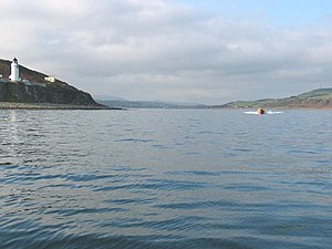
Campbeltown Loch looking west. Davaar Island with its lighthouse can be seen on the left. |
||
| Waters | Kilbrannan Sound | |
| Land mass | Kintyre | |
| Geographical location | 55 ° 25 '15 " N , 5 ° 34' 40" W | |
|
|
||
| Islands | Davaar | |
Campbeltown Loch is a bay on the southeast coast of the Kintyre Peninsula in Scotland . At her head lies the town of Campbeltown , from which her name is derived; in the middle of the driveway is the uninhabited tidal island Davaar . Campbeltown Loch opens east to Kilbrannan Sound , a tributary of the Firth of Clyde . The bay extends about three kilometers into the country and has a maximum width of about 1.5 km. Campbeltown Loch is subject to the tides. At low tide Davaar can be reached on foot via "The Doirlinn", a gravel strip. The Mull of Kintyre begins south of Campbeltown Loch .
Individual evidence
- ^ Entry in the Gazetteer for Scotland
- ^ N. Wilson, A. Murphy: Scotland , Lonely Planet, 5th Edition, 2008, p. 322. ISBN 978-1-741-04725-7
Web links
Commons : Campbeltown Hole - collection of pictures, videos and audio files


