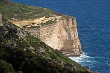
Dingli Cliffs
The Dingli Cliffs are a cliff formation on the coast of the island of Malta in the Mediterranean Sea and the highest point in the Maltese archipelago. Located near the village of Dingli , the Dingli Cliffs rise up to 253 meters above the Mediterranean Sea by the mountain or the Ta 'Dmejrek elevation . On the southwest coast of the island of Malta, the rock face drops steeply in many places, but nowhere as high as on the Dingli Cliffs. A little below the edge of the cliff there is a green and fertile rock plateau above the coastline, where agriculture is practiced.
The Dingli Cliffs owe their name to the English knight Sir Thomas Dingley, who settled in the area in the 16th century.
Above the Dingli Cliffs is a small chapel and also a former Royal Air Force radar station . This dome-shaped system is used today by the Maltese air traffic control.
Web links
Coordinates: 35 ° 51 ′ 3 ″ N , 14 ° 22 ′ 50 ″ E

