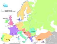
European altitude reference system
The European Vertical Reference System (EVRS) is the vertical coordinate reference system for Europe. The EVRS is defined by 4 stipulations. They describe:
- the zero point of the height system
- the altitude type
- the unit of measurement of heights
- the nature of the consideration of deformations of the earth's surface as a result of tidal effects (solid earth tides, Eng. solid earth tide, see Earth , Earth tide )
The zero level of the heights in the EVRS therefore refers to the zero point of the Amsterdam water level (NAP), which corresponds to the mean flood at the end of the 17th century.
The EVRS was first defined at the symposium of the European sub-commission of the International Association of Geodesy (EUREF) in Tromsø in 2000. In 2008 the definition was modified and supplemented by the publication of the "EVRS Conventions 2007". The INSPIRE initiative of the European Union recommends the use of the EVRS for the specification of heights in a European context. Most European countries continue to use their national altitude reference systems for national purposes. In order to be able to use uniform heights for cross-border projects, transformations between the national height reference systems and the EVRS are calculated and published.
Height information in the EVRS
The heights of the EVRS are calculated through the joint evaluation of national leveling networks in the United European Leveling Network (UELN) and given as geopotential heights and normal heights derived from them .
Heights in the EVRS are re-determined at certain time intervals from the evaluations of the UELN in its respective extent with the respective current measurements of the European countries involved. These evaluations are called implementations of the EVRS and are referred to as the European Vertical Reference Frame (EVRF). Previous implementations are the EVRF2000, the EVRF2007 and the EVRF2019.
| Realization of the EVRS | EVRF2000 | EVRF2007 | EVRF2019 |
|---|---|---|---|
| Number of countries involved | 22nd | 26th | 30th |
| Number of leveling points | 3064 | 7942 | 10758 |
| Number of measurements | 4263 | 10354 | 13636 |
EVRF2019
A weak point of the UELN and thus of the EVRS realizations is the inhomogeneity of the underlying data both with regard to the measurement period and the accuracy of the leveling measurements in the various European countries.
The year of measurement of the height differences in EVRF2019 varies between 1923 and 2018. About half of the height differences were measured after 2000, the majority of the remaining data comes from the 1990s. When calculating the EVRF2019, models of the postglacial land uplift in Scandinavia and the Alpine uplift in Switzerland ( elevation (geology) ) were therefore used to take into account the changes in elevation within the measurement period in these areas and to relate the elevations to a common reference epoch (kinematic adjustment ). The reference epoch of the EVRS2019 is the year 2000.
In leveling, the measurement accuracy is usually specified as the standard deviation of the measurement of a height difference over a distance of 1 km. This value is on average for the entire leveling network in all 3 realizations at ± 1.1 mm. However, the measurement accuracy varies between the individual countries from ± 0.5 mm to ± 2.4 mm. The standard deviation of a calculated height is on average ± 20 mm, the values in the EVRF2019 fluctuate between ± 5 mm and ± 100 mm.
Availability of results
The heights of the EVRF2000 and EVRF2007 were not published, but only exchanged between the countries participating in the UELN. The heights of the EVRF2019 are available on the internet.
literature
- Christian Gerlach, Thomas Gruber, Reiner Rummel: Next generation height systems . In: Willi Freeden, Reiner Rummel (ed.): Earth measurement and satellite geodesy: Handbook of geodesy (= Springer Reference Natural Sciences ). Springer, Berlin / Heidelberg 2017, ISBN 978-3-662-47100-5 , pp. 349-400 , doi : 10.1007 / 978-3-662-47100-5_7 .
- Johannes Ihde, Wolfgang Augath: The European Vertical Reference System (EVRS), Its relation to a World Height System and to the ITRS . In: József Ádám, Klaus-Peter Schwarz (Ed.): Vistas for Geodesy in the New Millennium (= International Association of Geodesy Symposia . Volume 125 ). Springer, Berlin / Heidelberg 2002, ISBN 978-3-662-04709-5 , pp. 78-83 , doi : 10.1007 / 978-3-662-04709-5_14 .
- J. Ihde et al. a .: EUREF's contribution to national, European and global geodetic infrastructures . In: C. Rizos, P. Willis P. (Eds.): Earth on the Edge: Science for a Sustainable Planet. International Association of Geodesy Symposia . tape 139 . Springer, Berlin / Heidelberg 2014, p. 189-196 .
- M. Sacher: The European Vertical Reference System (EVRS) - development and latest results. In: 21st EGU General Assembly, EGU2019, Proceedings from the conference held April 7-12, 2019 in Vienna, Austria. April 2019.
- M. Sacher, G. Liebsch, J. Ihde, J. Mäkinen: EVRF2007 as Realization of the European Vertical Reference System . In: Bollettino di Geodesia e Scienze Affini . tape 78 . Instituto geografico militare, Florence 2009, p. 35-50 .
Individual evidence
- ↑ a b "EVRS / References / Bibliography" website Federal Agency for Cartography and Geodesy 2009. Accessed on March 12, 2020
- ↑ “Data Specification on Coordinate Reference Systems - Technical Guidelines” INSPIRE website of the European Commission 2014. Accessed on March 12, 2020
- ↑ "CRS-EU" website Federal Agency for Cartography and Geodesy 2014. Accessed on March 12, 2020
- ↑ "EVRS" website Federal Agency for Cartography and Geodesy. Retrieved March 12, 2020
- ↑ "EVRF2019 heights" website Federal Agency for Cartography and Geodesy 2020. Accessed on March 12, 2020
