GenGIS
| GenGIS
|
|
|---|---|
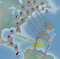
 Biodiversity of 19 marine metagonomes from the Global Ocean Sampling Expedition |
|
| Basic data
|
|
| developer | Donovan Parks, Mike Porter, Timothy Mankowski, Suwen Wang, Sylvia Churcher, Alex Keddy, Christian Blouin, Jacqueline Whalley, Stephen Brooks, Rob Beiko |
| Current version | 2.5.0 (March 9, 2016) |
| operating system | Mac OS , Windows |
| category | Bioinformatics |
| License | GNU GPL 3.0 |
| kiwi.cs.dal.ca/GenGIS | |
GenGIS is a free and open source software for geo and bioinformatics .
GenGIS is designed for handling large data sets from ecology and ( phylo ) genetics as well as the integration of maps. With regard to maps, vector data and raster data are supported, which includes both maps of the initial topology to visualize 3D terrain and geo-referenced image files for satellite images . It is possible to test geographical axes that correspond to migration routes. Taxonomies or molecular functions can be saved in an optional file in order to map sequence data.
Own scripts for data analysis can be executed within GenGis with Python and R. Statistics functions already included include regression analysis , the Mantel-Haenszel test , the calculation of alpha diversity and the visualization of matrices with highlighted pair comparisons .
literature
- Donovan H. Parks et al .: GenGIS 2: Geospatial Analysis of Traditional and Genetic Biodiversity, with New Gradient Algorithms and an Extensible Plugin Framework . In: PLoS One . tape 8 , no. 7 , 2013, p. e69885 ( online ).