Geothermal information system
|
|
|
|---|---|
| Internet-based map application | |
| operator | Leibniz Institute for Applied Geophysics (LIAG) |
| editorial staff | Leibniz Institute for Applied Geophysics (LIAG) |
| Registration | No |
| On-line | July 2006 |
| https://www.geotis.de | |
The aim of the geothermal information system is to improve the quality of the planning of geothermal systems and to minimize the risk of discovery. The system is freely accessible to everyone via the Internet and is thus constantly updated. The project is funded by the Federal Ministry for the Environment, Nature Conservation and Nuclear Safety (BMU).
The project
The geothermal information system offers its users a compilation of data and information about deep aquifers in Germany that are suitable for geothermal use. Basically, it is to be seen as a digital version of a geothermal atlas, which is largely independent of scale and is always available in the current edition. Basic geoscientific data as well as current knowledge and results are provided and continuously updated. Despite the large amount of incoming data, GeotIS will not replace a local feasibility study. The system has been freely available via the Internet in the area of geothermal potentials since May 2009, whereby the property rights to the basic data must be taken into account in a suitable manner.
Another product of this project is the directory of geothermal locations , which provides an overview of geothermal systems in Germany.
Maps of the temperature field in the subsurface of Germany prepared in the LIAG and available for download provide insight into different depths.
Geothermal locations
The directory of geothermal locations is an information system available on the Internet about deep geothermal systems in Germany that are in operation or under construction. Systems that use near-surface geothermal energy are not included in the directory. The presentation is based on a map of Germany with the administrative boundaries. Furthermore, the user can have the individual federal states displayed via a selection box, whereby, among other things, reference is made to the relevant competent authority.
Information on the individual geothermal systems, which are differentiated into the various types of use based on their symbols (balneological use, power generation, etc.) can be called up - if available - at the click of a mouse. The user can choose between different map contents, e.g. B. Topography (DLM 250), energy consumption and population density. The locations are displayed using UMN MapServer.
Emergence
The group of people deep geothermal energy of the ad hoc working group geology of the federal-state committee soil research (BLA-GEO) has created a directory of all geothermal systems in Germany. This table includes geothermal systems in Germany in operation, construction and planning. However, only those locations that are already in operation and under construction are published on the Internet. Under construction means that at least one borehole has been sunk.
The individual data come from the representatives of the geological services of the federal states. No guarantee is given for the completeness and correctness of the information.
Geothermal potentials
The data basis for the information system Geothermal Potentials is on the one hand more than 30,000 boreholes; these are predominantly oil-natural gas wells, but also geothermal, thermal and mineral water wells as well as mining wells. A further component is the hydraulic data (porosity and permeability values, tests) from the specialist information system for hydrocarbons of the State Office for Mining, Energy and Geology (LBEG), the data stocks of the project partners and the main storage tank drilling data from the former GDR. The temperature data from the LIAG's geophysics information system and the structural data from various maps and work by the project partners are also incorporated into the system.
Geological profiles, geothermal map material and basic data from databases are processed into 3D underground models. These models form the most important data basis of the information system.
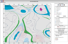
The research in GeotIS takes place exclusively over the Internet. The research interface enables the dynamic generation of interactive maps in which specialist information is combined with topographical and statistical data. Dynamically generated vertical and horizontal sections down to a depth of 5000 m below sea level offer detailed insight into the subsurface. The vertical section is in principle a geological profile. In addition to the course of geothermally relevant stratigraphic horizons, nearby boreholes are also mapped; In addition, the temperature profile can be displayed in the form of isolines. The horizontal section allows a view of both the lateral temperature distribution and the stratigraphy at a certain depth. It is also possible to display the temperature distribution on the base or top of a stratigraphic unit.
literature
- R. Schulz, T. Agemar, A.-J. Alten, K. Kühne, A.-A. Maul, S. Pester and W. Wirth: Development of a geothermal information system for Germany . Petroleum natural gas coal 123, 2: 76-81; Hamburg 2007
- S. Pester, R. Schellschmidt and R. Schulz: Directory of geothermal locations - Geothermal plants in Germany at a glance . Geothermal energy 56/57: 4-8. 2007


