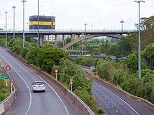
Grafton Bridge
The Grafton Bridge is a reinforced concrete bridge in Auckland , New Zealand that was commissioned in 1910 and , with an arch span of 97.6 meters, was the largest bridge of its kind in the world at the time.
geography
The bridge is located between the junction of Karangahape Road / Symonds Street and Grafton Road / Park Road in the Grafton district of Auckland City . The bridge runs in two lanes in an east-west direction over the valley of the Waiparuru Stream . At the same time it bridges the two New Zealand State Highways 1 and 16 , which connect further north to the inner city.
Construction and data
The bridge was made of reinforced concrete and has a total length of 296 meters. The two arches running parallel across the valley of the Waiparuru Stream have a span of 97.6 meters. These rise 25.6 meters above their supporting pillars and 43.3 meters above the bottom of the valley.
The bridge was constructed and designed by engineers Robert Forbes Moore and Karl Rosegger , with Rosegger doing the calculations for the construction. The calculations were checked by the German professor Emil Mörsch, who at the time was recognized worldwide as an expert in reinforced concrete structures .
history
The Grafton Bridge had two previous bridges, each made of wood. The first bridge, designed by William Anderson , was built in 1884 and was designed and built as a pure pedestrian bridge. But after concerns about the stability of the bridge arose, the simultaneous use was reduced to a certain number of people in 1890 and compliance with the restriction was checked by security guards on both sides of the bridge. But after the city's engineers became aware of the poor condition of the bridge in 1904, a second smaller bridge was built across the Waiparuru Stream parallel to the first . After the old wooden bridge was removed on September 16, 1906, one year later construction work began on the Grafton Bridge , which was to be made of reinforced concrete.
The Ferro-Concrete Company of Australasia Limited was commissioned with the construction project , but after a good half of the construction period, the company files for bankruptcy in 1909. The contract clause that the money for the construction is only paid when the bridge arch has been successfully tested brought the company into financial difficulties, because it is common that payments are made after the completion of construction sections.
However, so that the building could be completed, the city itself took on the execution of the construction project. In 1910 the time had come. After the completion of the bridge, each arch was loaded with 292 tons of material for testing on March 15, 1910 and officially opened and opened to traffic on April 28, 1910 by the then Mayor Charles D. Gray . The bridge was illuminated and has long been the attraction in Auckland .
But the bridge structure also attracted people who wanted to kill themselves and jumped down from the bridge. To counter this, a chain link fence was erected on the railing of the bridge in 1957. Having become unsightly over the years, the wire mesh was removed again in 1996, with the effect that the suicide rate skyrocketed by five times. However, it was not until 2002 that the city council decided to erect a curved Plexiglas screen on the railing of the bridge, which made jumping from the bridge into the depths impossible.
In 2009 the construction of the Grafton Bridge was strengthened and made more earthquake-proof according to the current status. At the same time, the load capacity of the structure could be increased from 13 tons to 40 tons and the frequency of the buses operating on it increased to around 1200 daily.
Web links
- Grafton Bridge . Heritage New Zealand,accessed January 2, 2017.
- Grafton Bridge . Engineering New Zealand,accessed September 8, 2019.
Individual evidence
- ↑ Heritage: Grafton Bridge . Karangahape Road Business Association , accessed January 2, 2017 .
- ^ Grafton Bridge . IPENZ Engineering Heritage , archived from the original on April 8, 2017 ; accessed on September 8, 2019 (English, original website no longer available).
- ^ Barriers on Grafton Bridge . In: Te Ara - Enciclopedia of New Zealand . Ministry for Culture & Heritage , accessed January 2, 2017 .
Coordinates: 36 ° 51 ′ 33.9 ″ S , 174 ° 45 ′ 54.8 ″ O


