Hyperspectral
In remote sensing, hyperspectral is a sensor system that can record images of a large number of closely spaced wavelengths . The eye sees the environment multispectrally in the wavelengths of the primary colors red, green and blue. Hyperspectral systems record data from 20 to 250 different channels, ranging from wavelengths in the ultraviolet range to long-wave infrared. Hyperspectral sensors are usually used from airplanes or satellites. From the reflective properties of vegetation and soil formations, z. B. on vegetation indices derived statements about the health status of the plants. In contrast to a panchromatic recording, a lower spatial resolution is obtained.
Techniques for Acquiring a Hyperspectral Data Cube
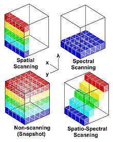
To obtain the hyperspectral data cube with its two spatial and one spectral dimensions, four basic techniques are available:
- Snapshot (the entire data set is delivered with a single detector output)
- Spatial scanning (each detector output provides the spectrum from a narrow strip of the scene)
- Spectral scanning (each detector output provides a monochromatic, spatial map of the scene)
- Spatial-spectral scanning (each detector output provides a spectrally encoded, spatial map of the scene)
