Inaccessible Islands
| Inaccessible Islands | ||
|---|---|---|
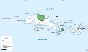
| Map of the South Orkney Islands, the Inaccessible Islands in the far west | ||
| Waters | Southern ocean | |
| archipelago | South Orkney Islands | |
| Geographical location | 60 ° 34 ′ S , 46 ° 44 ′ W | |
|
|
||
| Residents | uninhabited | |
Inaccessible Islands (from the English translated mutatis mutandis inaccessible islands ) are a group of small uninhabited islands in the archipelago of South Orkneys in the Antarctic Ocean .
The Inaccessible Islands are about 30 km west of Coronation Island , the largest island in the archipelago, and represent the westernmost landmass of the South Orkney Islands. They rise steeply from the ocean and reach heights of 120 to 215 m above sea level.
The islands may have been discovered by Nathaniel Palmer as early as 1820 and were named Seal Islands . The discovery by the British seal hunter George Powell (1794–1824) in December 1821, who baptized them Inaccessible Islands because of their supposed inaccessibility , is considered to be certain .

