Isoseiste
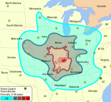
Isoseists are isolines that connect locations of equal (integer) intensities of an earthquake .
The intensity of an earthquake is determined according to an intensity scale such as the Mercalli scale or the MSK scale and is usually determined through questionnaires . The intensity is based on the subjective perception of audible and tangible effects and the subjective classification of the damage effects that an earthquake causes at a certain location. Since the effects of the vibrations decrease with distance from the epicenter and are also influenced by numerous other factors such as B. depend on the hearth process or the nature of the subsurface, the intensity is a location-dependent variable. It is not to be confused with the magnitude of an earthquake.
The determined spatial distribution of the intensities is shown in a so-called isosist map . The isoseists practically always represent themselves as closed lines around the epicenter, which are interpolated from the specified local intensities . The shape of the lines depends in particular on the radiation characteristics of the released seismic energy and the nature of the ground (transmission of seismic waves ), but is also influenced by factors such as population density [evidence?] And the general ground unrest .
Since the scales used only know whole-number values, the innermost of the isoseists also gives the maximum intensity I 0 . The isoseist map not only enables conclusions to be drawn about the location of the epicenter, but also provides clues about the depth of the hypocenter via the distance between the isoseists and, within the scope of the accuracy of the subjective information, also allows statements to be made about the wave propagation and the relationship to geological structures.
literature
- Hans Berckhemer : Fundamentals of geophysics. 2nd Edition. Scientific Book Society, Darmstadt 1997, ISBN 978-3-534-13696-4 .
