Marlborough Fault Zone
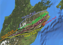
The Marlborough Fault Zone (MFZ), sometimes also called the Marlborough Fault System , consists of a system of four major and many minor geological faults in the Marlborough region and in the north of the Canterbury region on the South Island of New Zealand .
geography
Geographically, the Marlborough Fault Zone can be delimited in the west from the catchment area of the Otira River to Waipara on the east coast and from the Otira River to the north via Murchison, following the Wairau River to the north coast. The entire Marlborough District and the northern part of Canterbury are thus part of the zone.
The four faults that define the Marlborough Fault Zone include:
- the Wairau Fault , which can be seen as a continuation of the Alpine Fault and, as the northernmost of the four faults, shifts laterally against each other in a horizontal direction at a speed of 3.5 mm per year (GPS data from 2009), with the southern part moving to the southwest. The fault runs northeast to Cook Strait .
- the Awatere Fault , which branches off further south from the Alpine Fault , runs almost parallel to the Wairau Fault and also ends at the Cook Strait . This fault is shifting at a rate of 5.7 mm per year (GPS 2009).
- the Clarence Fault shifts at 5.3 mm per year (GPS 2009), but is only half as long as the Awatere Fault and does not begin at the Alpine Fault and also does not end at the Cook Strait .
- the Hope Fault is the longest contiguous fault among the four at over 230 km. At 18 mm per year (GPS 2009), it is also the one that moves the fastest.
What all faults have in common is that the rock layers shift horizontally to the right in a south-westerly direction, with the Chatham Rise , the part of the Zealandia continental plate on which the south-eastern part of the South Island is located, moving in the same direction at a rate of 41 mm per year as the aforementioned faults shifts.
See also
literature
- Stephen Bannister, Donna Eberhart-Phillips : 3-D imaging of Marlborough, New Zealand, subducted plate and strike-slip fault systems . In: Oxford University Press (Ed.): Geophysical Journal International . Vol. 182 , 2010, pp. 73–96 , doi : 10.1111 / j.1365-246X.2010.04621.x (English).
Individual evidence
- ^ A b Bannister, Eberhart-Phillips : 3-D imaging of Marlborough, New Zealand, subducted plate and strike-slip fault systems . In: Geophysical Journal International . 2010, p. 76 (English).
- ^ Robert Langridge, Jocelyn Campbell, Nigel Hill, Verne Pere, James Pope, Jarg Pettinga, Beatriz Estrada, Kelvin Berryman : Paleoseismology and slip rate of the Conway Segment of the Hope Fault at Greenburn Stream, South Island, New Zealand . In: Geoscience Society of New Zealand (Ed.): Annals of Geophysics . Vol. 46 N. 5 . Wellington October 2003, p. 1119 (English).
- ^ Bannister, Eberhart-Phillips : 3-D imaging of Marlborough, New Zealand, subducted plate and strike-slip fault systems . In: Geophysical Journal International . 2010, p. 74 (English).
