Otira River
| Otira River | ||
|
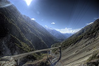
Upper course with Otira Viaduct |
||
| Data | ||
| location | South Island , New Zealand | |
| River system | Taramakau River | |
| Drain over | Taramakau River → Tasman Sea | |
| source | at Mount Rolleston in Arthur's Pass National Park 42 ° 54 ′ 8 ″ S , 171 ° 31 ′ 23 ″ E |
|
| muzzle | below Otira in the Taramakau River Coordinates: 42 ° 45 ′ 0 ″ S , 171 ° 38 ′ 0 ″ E 42 ° 45 ′ 0 ″ S , 171 ° 38 ′ 0 ″ E
|
|
| length | 20 km | |
The Otira River is a river on the South Island of New Zealand . Its source is on Mount Rolleston in the Southern Alps . The river flows 20 km in a northerly direction, passes Otira and then flows into the Taramakau River as the only major tributary . The valley of the Otira River and the SH 73 form the north-western access to Arthur's Pass , one of the three important passes over the Southern Alps.
