New Zealand Alps
| New Zealand Alps Southern Alps Tiritiri-o-te-moana |
|
|---|---|
|
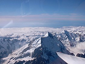
The southern Alps are covered with snow here |
|
| Highest peak | Aoraki / Mount Cook ( 3724 m ) |
| location | New Zealand |
| part of | South island |
| Coordinates | 43 ° 36 ′ S , 170 ° 10 ′ E |
| Type | Fold Mountains |
| Age of the rock | 100 to 150 million years |
The Southern Alps , South Alps or often Südalpen ( English Southern Alps ) called on Māori Tiritiri-o-te-Moana , are a young fold mountains that the South Island of New Zealand by pulling on the length. The central core area with heights of over 1500 meters extends over around 360 kilometers with an average width of around 50 kilometers. The highest mountain is the Aoraki / Mount Cook ( Maori : Aoraki = "Wolkenstecher" ) with 3724 m .
The New Zealand Alps are similar to the European Alps in several ways. So they reach heights as they occur in the Eastern Alps and are partly glaciated. Distinctive mountain peaks and easily distinguishable summit shapes are also often formed. They are also located in the cool temperate climate zone and are covered with forests due to the low population density of New Zealand. The geomorphology is also similar, although the slopes in the northwest drop off sharply towards the coast.
geology
They were formed around 100 to 150 million years ago earlier than the European Alps. Even today, 17 peaks are over 3000 meters high.
Due to its location on the plate boundary between the Pacific and Australian plates , the New Zealand Alps are still in the so-called uplift phase . However, due to the strong erosion , the mountains are just as quickly eroded.
As part of the Pacific Ring of Fire , volcanoes and earthquakes are part of the surface of the mountain range. Hot springs provide electricity and heat in some areas.
climate

The mountains form a distinctive climatic divide between the humid north-west coast and the steppe-like dry landscape in its slipstream in the south-east of the island.
The prevailing westerly winds cause a weather phenomenon known as the Nor'west arch (north-west arch). The humid air that flows over the mountains forms an arc of clouds in the blue sky. This weather pattern is often seen over Canterbury and north Otago in summer . Another consequence of the westerly winds is the Nor'wester , a foehn wind .
From the Southern Fiordland in the south to the Spenser Mountains in the north, the New Zealand Alps are glaciated.
The research project World Glacier Inventory (WGI), which inventories all glaciers from 1 hectare in area , counted around 3,155 glaciers on the South Island at the turn of the millennium, of which only 330 have an official name. Their surface added up to a total of 1159 km² with an estimated ice volume of 53.3 km³ at that time. There is also pronounced glacier melting on New Zealand . Between 1978 and 2014, New Zealand's glaciers lost a total of 19.3 km³ of ice volume (corresponding to 36%). The total ice volume in 2014 was about 34.3 km³.
In addition to numerous smaller individual glaciers, there are four larger contiguous glacier areas in the vicinity of Aoraki / Mount Cook , Mount Aspiring , Mount Whitcombe and Mount Tutoko . The most famous glaciers include the Franz Josef and Fox glaciers on the west coast. Due to the high flow speed, its glacier tongues reach down to an altitude of 300 meters. Another special feature is that these glaciers are surrounded by temperate rainforest in the lower part .
The Franz Josef Glacier was named after the Austrian Emperor by Julius von Haast , a German geologist. It is 12 kilometers long and about 800 meters wide.
The Fox Glacier is only 25 kilometers away from the Franz Josef Glacier and a little longer with a length of 13.5 km. It was named after the Prime Minister Sir William Fox .
The longest glacier in the New Zealand Alps is the Tasman Glacier near Mount Cook with a current length of 27 kilometers. However, it is currently shortening noticeably, so that even large parts in the lower area only leave apere rubble fields.
tourism
The region is considered to be very natural, as tourism is limited. Nevertheless, the New Zealand Alps are the main attraction for winter sports in New Zealand and are home to the Coronet Peak and Mount Hutt ski areas .
National parks
Westland National Park , Mount Aspiring National Park , Mount Cook National Park and Arthur's Pass National Park are all located in the New Zealand Alps .
mountains
| mountain | Maori | height |
|---|---|---|
| Aoraki / Mount Cook | Aoraki | 3724 meters |
| Mount Tasman | 3498 meters | |
| Mount Dampier | Rakiroa | 3440 meters |
| Silberhorn | 3300 meters | |
| Mount Hicks | 3216 meters | |
| Painted Brun | 3199 meters | |
| Torres Peak | 3165 meters | |
| Mount Sefton | 3157 meters | |
| Mount Haast | 3138 meters | |
| Mount Elie de Beaumont | 3117 meters | |
| Douglas Peak | 3085 meters | |
| Mount La Perouse | 3081 meters | |
| Mount Haidinger | 3068 meters | |
| Mount Aspiring | Tititea | 3055 meters |
| Mount Magellan | 3049 meters | |
| The minarets | 3048 meters | |
| Mount Dixon | 3004 meters |
See also
Individual evidence
- ↑ Tiritiri-o-te-moana, Te . In: Te Aka Online Māori Dictionary . Accessed December 31, 2019 .
- ↑ New Zealand's highest mountain has shrunk 30 meters Yahoo News, AFP, January 17, 2014 (accessed January 17, 2014)
- ^ World Glacier Monitoring Service (2009): World Glacier Inventory. http://nsidc.org/data/glacier_inventory/browse.html
- ↑ Trevor JH Chinn (2000): Glaciers of Irian Jaya, Indonesia, and New Zealand - New Zealand Geological Survey, University of Canterbury, Christchurch, New Zealand http://pubs.usgs.gov/pp/p1386h/nzealand/nzealand. html
- ^ Change in glacier ice volume. In: New Zealands's Environmental Reporting Series - Environmental Indicators Te taiao Aotearoa. Ministry for the Environment and Statistics New Zealand , October 25, 2015, accessed March 17, 2018 .


