
Eastern Alps
| Eastern Alps | ||
|---|---|---|
 Alpine subdivision into western and eastern Alps |
||
| Highest peak | Piz Bernina ( 4049 m ) | |
| location | Italy , Switzerland , Germany , Liechtenstein , Austria , Slovenia | |
| part of | Alps | |
|
||
| Coordinates | 47 ° 0 ′ N , 12 ° 0 ′ E | |
| Type | Ceiling / fold mountains | |
| Age of the rock | Alpidian phase (100–50 mya ) | |

Eastern Alps is the name for the eastern part of the Alps . They encompass the mountain ranges east of an imaginary line from Lake Constance along the Rhine over the Splügen Pass to Lake Como . Compared to the Western Alps , they are lower and gentler, with less high passes . The Eastern Alps run from Switzerland and Liechtenstein through all of Austria - from Vorarlberg to Burgenland and reach Hungarian territory and the northern edge of Italy to Slovenia . They also roam Germany , where they make up the entire part of the Alps.
introduction
The Eastern Alps are lower than the Western Alps , and most of their passes do not reach heights as high as those of the Western Alps. The Alpine arc in the east is less curved than the western Alpine arc. The eastern Alps show in their western area a strongly south-western vergente transverse fold that bulges out to Verona . The middle part is clearly structured east-west, these longitudinal valley furrows of the great Alpine rivers Inn , Salzach , Enns , Etsch / Eisack , Gail / Drau and Mur / Mürz , which follow the tectonic faults, divide the Eastern Alps into characteristic chains . These chains fan out towards the east, enclosing several large peripheral bays ( Vienna Basin , Graz Basin and others). In the north, where they approach the Bohemian Massif within a few kilometers, they turn northeast towards the Carpathian Mountains (sunk up to 6 kilometers in depth). In the middle, a branch dips into the Pannonian Basin . The southern chains turn south and merge into the Dinaric Mountains near the upper Adriatic . Overall, the Eastern Alps are broader and more diverse than the Western Alps, so that when crossing the Alps there are often 2 to 4 passes to be overcome.
Most of the Eastern Alpine rivers show sudden breakthrough valleys to the north or south, which also divide the Eastern Alps into several groups in the longitudinal direction. The largest inner-Alpine subsidence is the Klagenfurt Basin . The Eastern Alps are rich in lakes ( Salzkammergut , Carinthian lakes ) and moors . The highest mountain in the Eastern Alps is the Piz Bernina , which is its only four-thousand-meter peak at 4,049 meters .
The following countries have a share in the Eastern Alps (ranked according to mountain area):
- Austria : highest mountain Großglockner , 3798 m, in the Glockner group
- Italy : highest point in the Eastern Alps, La Spalla or Spedla (southernmost point of the Piz Bernina summit ridge ), 4020 m, in the Bernina group
- Switzerland : highest mountain in the Eastern Alps Piz Bernina , 4049 m, highest peak in the Bernina group
- Germany : highest mountain Zugspitze , 2962 m, in the Wetterstein Mountains
- Slovenia : highest mountain Triglav , 2864 m, in the Julian Alps
- Liechtenstein : highest mountain Grauspitz , 2599 m, in the Rätikon .
With an area of around 50 km² in the Ödenburg Mountains , Hungary also has a very small share in the Eastern Alps (highest elevation there: Magas-berc , 553 m, half of which is still in Austria).

Structure of the Eastern Alps
Geomorphological classification
The assignment in the northern, central and southern Alps is based on the large longitudinal valley ranges . These often follow the rock boundaries, but cut through the zones in places. The fine division mostly follows the valleys. In the Eastern Alps, the predominantly crystalline central Alps are separated from the northern and southern systems - especially the Northern and Southern Limestone Alps - by large lines of valleys .
- The northern Alps or North Eastern Alps (mostly Northern Limestone Alps ) include, from west to east, the Bregenz Forest Mountains , the Rätikon , the Lechquellengebirge , the Allgäu , Lechtal and Ammergau Alps , the Wettersteingebirge , the Karwendel - and Rofangebirge , the Bavarian Alps , the Kaiser Mountains , the Loferer Steinberge , the Leoganger Steinberge , the Berchtesgaden Alps , the Salzkammergut and the Lower Austrian Limestone Alps .
- The Central Alps are from west to east divided in Rhaetian Alps , Bernina , Ortler Alps , Verwall , Oetztal Alps , Zillertal Alps , High and Low Tauern and Lavanttaler or Noric Alps and Pohorje . The main Alpine ridge runs through you .
- The Southern Alps made from west to east: Bergamo Alps , Trentino Alps , Dolomites , Venetians , Carnic and Julian Alps and the Karavanke .
- Note: For the subgroups given here, see the list of mountain groups in the Eastern Alps (according to AVE) and below for the problem of classification in general .
cards
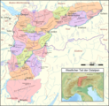
Western Eastern Alps
Middle Eastern Alps

Southern Eastern Alps


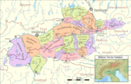
Tectonic division

Geologically , the Alps can be roughly divided into three regions: Western Alps , Eastern Alps and Southern Alps .
The western and eastern Alps are made up of extensive ceiling systems that have been pushed to the north more or less far beyond the European continental margin:
- Helvetic System (Helvetikum): The Helvetic nappes only appear on the extreme northern edge of the Eastern Alps (much more extensive in the Western Alps) and represent the European shelf . They were transported over relatively short distances.
- Pennine System (Penninikum): The Pennine nappes represent a former, relatively narrow ocean basin south of the European shelf, together with some continental fragments. They have been pushed over to the Helvetic Republic. In the Eastern Alps they appear almost exclusively in tectonic windows , for example in the Lower Engadine window in the west of Tyrol and in Graubünden, in the Tauern window in the east of Tyrol and in Salzburg, and in the window of Rechnitz ( Günser Mountains ). The Penninic nappes include the flysch zone (sandstone zone ) and various crystalline rocks .
- Eastern Alpine : The Eastern Alpine represents the northern shelf of the continental floe (s) that collided with Europe. It was probably transported over long distances, covered the Penninic in almost all of the Eastern Alps and thus dominated the geology there. So it builds the Northern Limestone Zone (Northern Limestone Alps), the Schist and Grauwackenzone , the crystalline zone (Central Zone, Central Eastern Alps), in the midst of which the Penninic units emerge in the tectonic windows, as well as the Gailtal Alps and the northern range of the Karawanken . In the western Alps, eastern alpine units only occur as isolated cover floes. This and the areal dominance of the Eastern Alps in the eastern part of the Alpine arc are the main reasons for the geological differentiation in the Eastern and Western Alps.
South of the fault line Gailtal – Eisenkappl ( periadriatic seam ) , the southern Alpine and Dinaric nappes emerge, which, in contrast to the Helvetic, Penninic and Eastern Alps, were pushed south. The transport distances were relatively short. Tectonically, all units south of this seam, i.e. almost the entire southern Alps, together with the Dinarides of the Balkans, form a separate system. This means, taken together with the above-mentioned points on ceiling construction, that neither the geographical term 'Alps' nor the geographical term 'Eastern Alps' denotes a self-contained geological complex.
Petrological classification
According to petrological criteria , the Eastern Alps are divided into seven rock zones . In contrast to the Western Alps, the Eastern Alps do not include any parautochthonous masses; they are a mountain range of ceilings and folds , in which western alpine ceilings only emerge at the edges and in geological windows.
- Sandstone zone (flysch zone) with molasse zone - narrow in the middle, widening towards the west and east
- Northern Limestone Zone (Northern Limestone Alps) - main body of the Northern Alps
- Northern slate – Grauwackenzone - limestone basement, mountain-forming in Tyrolean-Salzburg and Styrian-Lower Austria
- Crystalline zone - corresponds roughly to the main Alpine ridge or the central Alps
- Southern slate – Grauwackenzone - on the southern border of Austria
- Southern Limestone Zone (Southern Limestone Alps) - mostly in Slovenia and Italy
- Southern sandstone zone - hardly developed; in Italy
In East Tyrol and Carinthia, the ceiling structure and rock zones do not match. The Gailtal Alps lie north of the periadriatic seam, but are made of limestone and are therefore mostly included in the southern limestone zone (and thus in the southern Alps). The southern slate zone in the Carnic Alps is bordered in the north and south by trains of the southern limestone zone.
In the west there is a noticeable S-shaped curvature of the rock zones. The crystalline zone strikes in the Silvretta from the south and bends there to the east. The limestone mountains of the Rätikon lie south of the great long valley line. The Adige Valley south of Bolzano is a longitudinal valley in terms of rocks. The limestone zone forms a characteristic spur in the Lake Garda area , which is located dozens of kilometers south of the rest of the southern border.

On the problem of the division of the Alps in mountain groups
There is still no internationally recognized division of the Alps into sub-groups. In the literature of alpinism in Austria, Germany and South Tyrol, the Alpine Club division of the Eastern Alps from 1984, which is based on a quarter of the Eastern Alps, is common. The Swiss Alpine Club (SAC) divides the Swiss part of the Alps, also the part located in the Eastern Alps, which is called the Central Alps, on a first level along the cantonal borders (a political term) in order to delimit geographical units. In Austrian official and scientific works of hydrography , the strictly orographic mountain group classification according to Hubert Trimmel is generally used. The usual division in Italy and France is the Partizione delle Alpi 1926 for the entire Alps. A more recent approach is the Suddivisione Orografica Internazionale Unificata del Sistema Alpino (SOIUSA), which seeks to unite the AVE and the Partizione. In other states of the Alpine region or outside, as well as with various specialist and interest groups, other boundaries, classifications and boundaries of subgroups of the Alps are sometimes used.
Zone sequence in north-south direction
Northern Alps (Northern Eastern Alps)

The Northern Alps comprise a molasse zone , a sandstone zone , the northern limestone zone and most of the northern slate zone . The first two and the lower part of the Limestone Alps form the Northern Pre-Alps , the rest of the Limestone Alps form the High Limestone Alps , some of which are already glaciated, and in the south there is a zone that is partly similar to a low mountain range .
Northern sandstone zone / flysch zone and molasse zone
The sandstone zone , also known as the flysch zone , consists of rocks from the Cretaceous and the Old Tertiary. It rises clearly above the Alpine foothills . The flysch zone is relatively narrow (it takes up about a fifth of the northern Alps), forms parts of the Bregenzerwald in the west , to the east it stretches from the Salzach over the Salzkammergut Mountains , Eisenwurzen to the Vienna Woods , in between it is absent in some sections of the Bavarian Alps almost entirely. It is about 1000 m high in low mountain range , but in the southern Bregenzerwald it reaches over 2000 m, where parts of the Helvetic system protrude from Switzerland ( limestones such as on the Hochifen and the Kanisfluh ). In the Salzkammergut the border between flysch and lime forms a concise ceiling forehead ( Drachenwand , Schafberg , Höllengebirge , Traunstein ). The rocks of the zone as flysch , marl and shale are little resistance, they form typical of the Flyschzone back and summits ; in the west also ridges . The mountains of the flysch zone predominantly carry mixed deciduous forests and meadows . The often thick, loamy weathered cover tends to slide and the rapid runoff promotes the formation of floods .
The Subalpine Molasse forms the northern edge of the Alps. It is formed from the molasses deformed by the Alps, i.e. solidified erosion debris ( conglomerates ) of the early Alps. With the exception of the northern Bregenz Forest and the Allgäu, the landscape is hardly visible, but rather forms the transition area from the Alps to the northern Alpine foothills with its moraine landscape.
Northern Limestone Alps

The northern Limestone Alps consist of Mesozoic rocks (especially Triassic ). The Kalkalpen are divided into the Kalkvoralpen and the Kalkhochalpen .
Northern Limestone Prealps
The limestone foothills consist of dolomites and limestone and are a low mountain range with edges, cones and sticks, which can be up to 1600 m high. The northern limestone Alps are predominantly covered by mixed spruce forests. Karst phenomena arise in the limestone . The water-impermeable dolomite, on the other hand, is heavily disintegrated, with brittle rock formations and heaps of fine gravel. In the Kalkvoralpen there are individual higher elevations such as the Ötscher or the Sengsengebirge . However, their assignment to the Pre-Alps or the Kalkhochalpen is controversial.
Northern Limestone Alps
Slightly south of the limestone foothills, the rocky high limestone Alps extend , which mainly consist of limestone ( Wetterstein limestone in the west , Dachstein limestone in the east ) and Dolomites. From the Wilder Kaiser to the west, they mainly consist of arid chains that are steeply layered and provided with forest lines. In addition, the limestone high Alps are provided with ridges , peaks, towers, deeply eroded karen and mighty rubble heaps. The chain character, which predominates in the western limestone high Alps, is particularly pronounced in the Lechtal Alps (with the highest mountain in the Northern Alps), the Wetterstein Mountains and the Karwendel Mountains . From the Zahmer Kaiser to the east there are limestones with karstified, waterless, desolate plateaus with cart fields and sinkholes . Large stocks of leg pines (mountain pines) grow on it . A wide-meshed river network lies between the limestone plateaus in deep valleys and gorges. The plateaus show a humped, domed old landscape (called "Rax landscape" in the east) and preserve the flatter relief of the Tertiary Alps, which was not cut up as a result of karstification during and after the uplift of the mountains, but was reshaped during the Ice Age. The eastern limestone high Alps are plateau-like. Many caves are left as remains of former underground drainage. At the base of the limestone mountains there are salt and gypsum deposits , as well as spring horizons (karst springs) over slate.
Northern Slate – Grauwacken Zone

The slate – greywacke zone is a narrow strip of Paleozoic slate, sandstone and limestone. In the west, the Slate Alps (referred to by the population as "grass mountains") show alpine pastures and ridges and cuts rich in springs , above them in places ridges and peaks in harder slate and limestone: Kitzbühel Alps (Tyrolean) and Salzburg Slate Alps . In the Grauwackenzone , such as the Eisenerzer Alps , on the other hand, limestone blocks dominate the landscape. The shale zone contains deposits of iron and copper ore , magnesite , graphite and talc . The slate Alps are mostly to the north in the west and to the east (after the Dachstein massif , where it is almost interrupted) south of the longitudinal valley line, and are therefore mostly included in the central Alps.
Northern longitudinal valley train
The northern longitudinal valley range forms the approximate border between the northern and central Alps. It runs far within the slate zone or on its edge: Walgau (lower Ill ) - Klostertal - Arlberg - Stanzertal - Inntal - Zillertal - Gerlospass (or Inntal - valley furrow from Ellmau - pass from Grießen - Saalachtal - valley watershed from Zell - Salzachtal ) - Wagrainer Höhe - (or Fritztal ) - Ennstal - Paltental - Schoberpass - Liesingtal - Murtal - Mürz Valley - Semmering - Schwarzatal . From the west to the Schobersattel, the valley range is mostly wide, shaped from the Ice Age and shows alluvial cones of the side streams and terraces.
Central Alps

The Central Alps are largely identical to the crystalline zone, consisting of Precambrian and Paleozoic remains of the Variscan Mountains ("old crystalline") and the Tauern crystalline . They are mainly made up of hard, water-impermeable gneisses and granite gneisses as well as mica slate , in places with embedded limestone clods (for example south of Innsbruck ) and limestone bands.
The central Alps are rich in springs, streams and cirque lakes; in the west they have large glacier areas (especially Hohe Tauern , Zillertal , Stubai and Ötztal Alps , Silvretta, Ortler , Bernina ). There are clear differences in height and shape between the west and east of the Central Alps:
In the west there is the heavily cut Silvretta and Verwall groups with rugged "horns"; the massive, asymmetrical Ötztal and Stubai Alps with long side ridges to the north are heavily glaciated; here are Wildspitze (second highest mountain in Austria); Weißkugel and Zuckerhütl (named after its firn cover ).
To the east of the Brenner furrow there are elongated chains arranged in the shape of a feather, which are also known as "Keesberge" because of the glaciations ( Zillertal Alps and Hohe Tauern ).
Further characteristics of the western Central Alps and the Hohe Tauern (up to Katschberg ) are pyramid peaks, wide firn fields separated by rock ridges; lower down Kare with lakes, partly wide Karplatten; glacier tongues reaching at the beginning of the valley; deep, stepped and water-rich trough valleys ; extensive alpine pastures, larch and spruce forests .
In contrast, the eastern central Alps are lower and divided into several ridges, between which there are subsidence fields. The Niedere Tauern is not glaciated today, but has glacial shapes such as cirques and cirques, ridges and pyramid peaks (especially in the resistant granite gneiss ). To the south of the Mur-Mürz furrow , the low mountain ranges predominate despite heights over 2000 m : broad ridges are presumably remains of a tertiary bas-relief and only show karst formations in places. There are also more mats than rock regions and vast spruce forests. The south-western part of the Gurktal Alps is called the “Nockberge” because of its round shape.
The eastern mountain ranges separate characteristically towards the foothills in the east and southeast into two trains, one of which accompanies the northern limestone Alps to the northeast, and a southeastern branch. They enclose some subsidence and sediment basins , and large ridge-alpine basins in which crude oil and coal is extracted (especially Graz , Vienna and Fohnsdorf basins ), and also recent volcanism can be found ( Styrian volcanic land , Graz area). The Styrian peripheral mountains ( peripheral mountains east of the Mur ) still reach 2000 m and encompass the Graz Bay , the largest of the ridge alpine basins, in a semicircle , and end after the Hungarian border in forest-covered low mountain spurs. In the northeast, like the Vienna Woods , they border the broad depression of the Vienna Basin , where the former mountains are now below 2–6 km thick sediment layers. Beyond this fracture zone, some island mountains ( Leithagebirge and Hainburger Berge ) form a bridge to the Carpathian Mountains . Between them, the Danube River pushes through the Hainburger Pforte into the Hungarian Plain. In the south, the Central Alps extend into the Bacher Mountains (Pohorje) of Slovenia. To the east, the Central Alpine dips into the Pannonian Plain - and the depths can still be found in the Hungarian Danube region.
Southern alps

In the Southern Alps , the long valley range, which in the north represents a geologically significant boundary throughout, lies within the limestone zone. The non-calcareous zones pronounced in the north are absent in the south except for a rudimentary flysch zone, so that the terms Southern Eastern Alps, Southern Alps and Southern Limestone Alps largely refer to the same area. Only at the western end does the crystalline extend far to the south, so that here some massifs that do not belong to the southern limestone zone are to be counted among the southern Alps (and are summarized by the AVE as the western eastern alps ). In the east, too, crystalline masses such as the Bachergebirge, which lies south of the Drau , are partly assigned to the Southern Alps.
The southern Eastern Alps are not as clearly structured parallel to the latitude as the northern Alps. As a result of the S-shaped curvature, rocks in South Tyrol come from the south. The deeply cut Bozen porphyry plateau merges into the crystalline Sarntal Alps in the north . To the east are the southern limestone Alps made of Mesozoic rocks. Richly shaped reef limestone and dolomite form battlements, towers, sticks ( Marmolada ). In front of it there are alpine foothills made of slate. The Gailtal Alps, made of limestone and dolomite, peak in the wildly torn Lienz Dolomites and end in a plateau mountain ( Dobratsch ) in the east . To the south it is bounded by the straight valley of the Gail , which follows the periadriatic seam.
Southern Limestone Alps


The border between the Central Alps and the Southern Limestone Alps is formed by the fault line of the periadriatic seam .
Southern longitudinal valley train
The southern longitudinal valley line forms the border between the central and southern Alps. It runs from the Pustertal (Rienztal - Toblacher Feld - upper Drautal) through the Drautal further into the Klagenfurt basin to the valley of the Mieß / Meza. The longitudinal valley range is glacial widened and crisscrossed with large alluvial cones and wet valley floors.
Southern Slate Zone
The southern slate zone is no longer a longitudinal zone, but only forms an enclosed, more or less compact area. It consists of the Carnic Alps , with rounded slate mountains and saddles, which are surmounted by rugged blocks and teeth made of Paleozoic limestone ( Hohe Warte ). To the east of the Gailitz furrow are the limestone chains of the Karawanken ( high chair ). Under rock walls there is mostly dense spruce forest with relatively few alpine pastures. The southern tip of Austria still reaches the Steiner Alps .
Southern sandstone zone
The southern sandstone zone is only in the Lombard Alps between Lake Como and Lake Iseo (southern roofing of the Bergamasque Alps ), in the Venetian Alps (Belluno Prealps, southern parts of the southern Carnic Alps ) between Brenta and Tagliamento , and in the far east in the Friulian- Slovenian border area and in Find the valley of the Isonzo (Soča). In Trentino and the Lake Garda mountains , the limestone dips directly into the Po Valley .
| Bregenz Forest Mountains |
1 - Austria |
||||||
| Allgäu Alps | |||||||
| Lechquellen Mountains |
3a - Austria |
||||||
| Lechtal Alps |
3b - Austria |
||||||
|
Wetterstein Mountains & Mieming Range |
|||||||
| Karwendel | |||||||
|
Brandenberg Alps (Rofan) |
6 - Austria |
||||||
| Ammergau Alps | |||||||
| Bavarian Prealps | |||||||
| Rätikon | |||||||
| Silvretta |
26 - Switzerland Austria |
||||||
| Samnaun group |
27 - Switzerland Austria |
||||||
| Verwall |
28 - Austria |
||||||
| Sesvenna group |
29 - Switzerland Italy Austria |
||||||
| Plessur Alps |
63 - Switzerland |
||||||
|
Oberhalbsteiner Alps (Plattagruppe) |
64 - Switzerland Italy |
||||||
| Albula Alps |
65 - Switzerland |
||||||
| Bernina Alps |
66 - Italy Switzerland / Bernina group is part of the mountain range.
|
||||||
| Livigno Alps |
67 - Italy Switzerland |
||||||
| Bergamasque Alps |
68 - Italy |
||||||
|
Ortler Alps |
|
||||||
|
Adamello Presanella Alps |
49 - Italy |
||||||
| Garda mountains |
50 - Italy |
||||||
| Brenta Group |
51 - Italy |
| Dachstein Mountains |
14 - Austria |
| Dead Mountains |
15 |
| Ennstal Alps |
16 |
| Salzkammergut mountains |
17a 2,027 m - Austria |
|
Upper Austrian Pre-Alps |
17b |
| Hochschwab group |
18 2,277 m - Austria |
| Mürzsteg Alps |
19 Austria |
|
Rax Schneeberg Group |
20 Austria |
| Ybbstal Alps |
21 Austria |
| Türnitz Alps |
22 Austria |
| Gutenstein Alps |
23 Austria |
| Vienna Woods |
24 |
| Radstadt Tauern |
45a |
| Schladminger Tauern |
45b |
|
Rottenmanner & Wölzer Tauern |
45c Austria |
| Seckauer Tauern |
45d Austria |
| Gurktal Alps |
46a Austria |
| Lavanttal Alps | |
|
Edge mountains east of the Mur |
|
| Gailtal Alps |
56 |
| Carnic main ridge | |
|
Southern Carnic Alps |
57b |
| Julian Alps | |
|
Karawanken & Bacher Mountains |
|
| Steiner Alps |
Individual evidence
- ↑ Ingo Lachainer: Geology of the Eastern Alps and focus of excursions. ( Memento from September 27, 2006 in the Internet Archive ), Excursion Guide Alpine Excursion 1999, Institute for Geography and Spatial Research, Karl-Franzens University Graz (Version from September 6, 2012 on archive.is).
Web links
- Geology of the Eastern Alps , Ingo Lacheiner, Institute for Geography and Spatial Research, Karl-Franzens-University Graz, 1999