
Danube
| Danube | ||
 Danubian orographic system |
||
| Data | ||
| Water code | EN : 1 | |
| location | Central and Southeast Europe | |
| River system | Danube | |
| origin |
Breg spring in the Black Forest or the confluence of Brigach and Breg near Donaueschingen (see Danube spring ) |
|
| Source height | 1078 m or 680 m | |
| muzzle |
Black Sea Coordinates: 45 ° 9 ′ 46 " N , 29 ° 38 ′ 50" E 45 ° 9 ′ 46 " N , 29 ° 38 ′ 50" E |
|
| Mouth height | 0 m | |
| Height difference | 1078 m | |
| Bottom slope | 0.38 ‰ | |
| length | 2857 km (2811 km without Breg) | |
| Catchment area | 817,000 km² | |
| Discharge at the Achleiten A Eo gauge: 76,660 km² Location: 2,223.1 km above the mouth |
NNQ (09.10.1972) MNQ 1901–2006 MQ 1901–2006 Mq 1901–2006 MHQ 1901–2006 HHQ (10.07.1954) |
349 m³ / s 615 m³ / s 1430 m³ / s 18.7 l / (s km²) 4120 m³ / s 9100 m³ / s |
| Drain |
MQ |
6855 m³ / s |
| Left tributaries | (Selection) Altmühl , Naab , Regen , Ilz , Waag , Theiss , Sereth , Pruth ; completely see # tributaries |
|
| Right tributaries | (Selection) Iller , Lech , Isar , Inn , Enns , Traun , Raab , Drau , Save , Morava , Iskar ; completely see # tributaries |
|
| Reservoirs flowed through | Iron gate | |
| Big cities | Ulm , Ingolstadt , Regensburg , Linz , Vienna , Bratislava , Budapest , Novi Sad , Belgrade , Russe , Brăila , Galați | |
| Residents in the catchment area | 82,740,000 (2003) | |
| Navigable | 2655 km, of which 2414 km for large freight ships between Kelheim and Sulina | |
The Danube ( other names ) with an average water flow of around 6855 m³ / s and a total length of 2857 kilometers is the second largest and second longest river in Europe after the Volga . The river drains large parts of Central and Southeastern Europe. It flows through or touches ten countries ( Germany , Austria , Slovakia , Hungary , Croatia , Serbia , Bulgaria , Romania , Moldova and Ukraine ) - more than any other river on earth.
The Danube takes its name from the union of two source rivers, the Brigach and the larger Breg , both of which arise in the Central Black Forest . It crosses three large basin landscapes: the northern Alpine foothills and the Vienna basin (upper reaches), the Pannonian lowlands (middle reaches) and the Wallachian lowlands (lower reaches). It cuts through the separating mountains in narrow valleys , the most famous sections of which are the Danube Gorge near Beuron , the Wachau , the Hainburger Pforte (also Pressburger Pforte) and the Iron Gate . The river flows into the Black Sea via the extensive Danube Delta .
The Danube is one of the oldest and most important European trade routes and connects different cultures. Political tensions and wars repeatedly resulted in closures and obstructions on the waterway . Since the fall of the Iron Curtain , the Danube has regained its economic importance. The river connects many species-rich and unspoilt natural areas and is an important location for hydropower plants .
meaning
The Danube has a high geographical, historical and cultural importance in Europe and is comparable to the Rhine in the German-speaking area . With regard to the catchment area, it ranks second behind the Volga (1,360,000 km²) and in front of the Dnepr (531,817 km²) with 796,000 km² (8% of the area of Europe; according to other sources 817,000 km²) .
Names and etymology

Like most rivers in the German-speaking area, the Danube has a female name. In Middle High German she was called diu Tuonowe (early New High German Tonaw, Donaw ). The basic word -ouwe (' floodplain , river landscape') of their name, which is composed in Old High German, may have contributed to today's female gender.
All modern names of the river - including Romanian Dunărea , Bulgarian , Serbian and Croatian Dunav , Slovenian Donava , Hungarian Duna , Turkish Tuna as well as Slovak , Russian , Polish , Czech , and Ukrainian Dunaj - are initially derived from the name Dānuvius of the Roman times (with the river god of the same name ), but go back to older roots. Danube , like the river names Dnepr , Dniester , Donets and Don, is possibly of Iranian or Celtic origin. The names could come from the Iranian- speaking Scythians and Sarmatians as well as from the Celts of Eastern Europe. An exact linguistic assignment is difficult, as both tribes penetrated as far as the Don and the Danube, and both Celtic and Iranian are Indo-European languages and therefore the word "river" in Old Iranian (cf. avestisch dānu , Ossetian don ) and Celtic (cf. Welsh Donwy ) goes back to the same Indo-European root * dʰenh₂- 'flow'. In the Celtic language family, this is said to go back to the goddess Danu (also Danann ).
In ancient times, the Danube had two names for a long time: Ister or Hister , in ancient Greek Ístros ( Ἴστρος ), was a name for the lower reaches, the Danube was only called the upper reaches. Some Roman cities on the lower reaches of the Danube carried the addition ad Istrum - for example Nicopolis ad Istrum . This word is related to a general Indo-European hydronym * heisr- 'quickly, quickly' and is also derived from the Celtic words ys 'fast, tearing' and ura 'water, river'. According to another interpretation, ys also stands for 'high, low' and thus, like the Latin altus , denotes both aspects of the vertical . In the area of the earlier Celtic settlement area, in addition to the old names of the Danube, a number of other names for other rivers are derived from this tribe:
Hans Bahlow set the root initial * is- with the roots * es- , * as- , * os , * us- or * off- (all supposedly 'swamp / bog water') back. Another interpretation is based on a hypothetical Indo-European root * es or * is , which is interpreted as a generic term for '(flowing) water'.
Only at the turn of the century, when the Roman Empire had expanded over the entire course of the Danube and the cartographic connections were made accessible, was the unity of both river sections recognized. Ister was a common name for the river until the end of Antiquity , while Dānuvius only referred to the upper reaches. Since the Danube rises in the Black Forest and flows into the Black Sea , it is sometimes jokingly referred to as the Black River .
Catchment area
Geography and water flow

The catchment area of the Danube covers around 817,000 square kilometers. It's a bit asymmetrical; 56 percent of the area is to the left (north) of the Danube, 44 percent to the right. Nevertheless, the tributaries on the smaller right-hand side contribute around two thirds of the water volume, which is due to the larger area of the high mountains , which also absorb a large part of the moisture brought in by west and south-west winds.
This is reflected in the fact that in the southern Pannonian basin the Sava flows from the right, by far the most water-rich tributary and from the left, the Tisza, which is barely half its size, which is clearly the longest tributary of the Danube. Further down, the water flow of the Morava, coming from the right, exceeds that of the Prut , about five times as long, coming from the Danube Delta from the left by a good double. And also in the German Danube region the three largest left tributaries ( Altmühl , Naab and Regen ) together carry less water than the Lech, which is only the third largest right tributary in this part . By far the largest tributary of the Upper Danube, the Inn , is at least equal to the Danube at the confluence in Passau , and near Ulm the Danube is even surpassed by the Iller by a good third.
Most of the larger tributaries have their source in the Eastern Alps and Carpathians , as well as in the mountains of the Balkan Peninsula . The Carpathians are not the outskirts of the Danube catchment area, but protrude into it because they are drained on the east side by the Siret / Prut system. They separate the lower Danube region from the middle one. The Alps also jump in with their northeastern foothills and are divided into the middle and upper Danube.
Source rivers
At Donaueschingen , Brigach and Breg flow together to form the Danube. Of the two source rivers, the Breg, which rises somewhat to the south and higher, is the somewhat larger river according to all hydrological features. In addition, the source pot of the Danube brook near the junction of the two source rivers is traditionally considered the source of the Danube . From here the Danube has a length of a good 2810 kilometers.
Tributaries
The rivers Theiss , Pruth , Save , Drau , Olt , Sereth and Inn each have a length of over 500 kilometers. Rivers with a water flow of over 500 m³ / s are the Save, Theiss, Inn and Drau.

| Tributary | at km | Side R / L |
Length in km |
Discharge in m³ / s |
Remarks |
|---|---|---|---|---|---|
| Iller | 2587.9 | R. | 147 | 71 | carries more water at the confluence than the Danube |
| Lech | 2496.4 | R. | 264 | 114 | |
| Isar | 2281.7 | R. | 295 | 175 | |
| Inn | 2225.2 | R. | 518 | 738 | at the confluence wider and at times richer in water than the Danube |
| Traun | 2125.0 | R. | 153 | 135 | |
| Enns | 2111.8 | R. | 254 | 195 | |
| Leitha | ≈ 1830 | R. | 180 | 10 | flows into the Moson-Danube tributary |
| Raab | 1794.0 | R. | 250 | 18th | |
| Kapos | ≈ 1498 | R. | 113 | 4.4 | |
| Outside | 1382.5 | R. | 749 | 670 | |
| Save | ≈ 1170 | R. | 945 | 1722 | Most water-rich tributary of the Danube and longest from the right |
| Morava | 1104.5 | R. | 185 | 255 | |
| Timok | 845.7 | R. | 203 | 24 | |
| Iskar | 637.0 | R. | 368 | 54 | |
| Jantra | 536.7 | R. | 285 | 47 | |
| Altmuehl | 2411.6 | L. | 220 | 16 | |
| Naab | 2385.3 | L. | 165 | 50 | |
| rain | 2379.2 | L. | 169 | 40 | |
| Camp | ≈ 1985 | L. | 153 | 9 | |
| March | 1880.3 | L. | 358 | 109 | |
| Scales | 1765.8 | L. | 403 | 152 | |
| Hron | 1716.0 | L. | 298 | 55 | |
| Ipeľ | 1708.2 | L. | 233 | 21st | |
| Tisza | 1214.5 | L. | 1308 | 813 | longest tributary of the Danube |
| Timisoara | ≈ 1150 | L. | 340 | 47 | |
| Jiu | 691.6 | L. | 331 | 94 | |
| Olt | 600.6 | L. | 737 | 190 | |
| Vedea | ≈ 530 | L. | 224 | 12 | |
| Argeș | 432.0 | L. | 327 | 73 | |
| Ialomița | 231.1 | L. | 417 | 40 | |
| Sereth | 155.1 | L. | 596 | 230 | |
| Pruth | 134.1 | L. | 953 | 110 | |
Islands
The Danube has numerous larger and smaller islands. The best known are the Upper and Lower Wöhrd in Regensburg, the Jochenstein , the Danube Island in Vienna, the Great Schüttinsel , the Margaret Island in Budapest and the Great War Island near Belgrade.
The Danube States


Adjoining states
The Danube has ten riparian states (as of 2013) (in the direction of flow, with a share in the catchment area):
- on both banks
- one-sided
- Croatia 4.3%
- Bulgaria 5.9%
- Republic of Moldova 1.5%
- Ukraine 4.0%
A total of 1071 kilometers (37%) of the course of the Danube form a state border.
Other countries have shares in the catchment area of the river. In descending order of the area proportions, these are:
- Bosnia-Herzegovina 4.7%
- Czech Republic 3.0%
- Slovenia 2.2%
- Montenegro 0.9%
- Kosovo 0.7%
- Switzerland 0.2%
- as well as Italy , North Macedonia , Poland and Albania with less than 0.1% each .
The river system of the Danube is developed through numerous canals, in particular through the Main-Danube Canal and the canals to the northeastern neighboring river Dniester , so that countries such as France and the Benelux countries or Russia , Belarus and the Baltic States also have indirect inland waterway access to the Danube .
Cities on the Danube
The following cities are located on the Danube (* = capital):
|
in Germany |
in Austria |
in Slovakia in Hungary |
in Croatia in Serbia |
in Romania in Ukraine in Bulgaria |
course
Germany


Specifically, the Danube is created 1.4 kilometers east of Donaueschingen through the confluence of the two source rivers Brigach and Breg ("Brigach and Breg bring the Danube towards it"). Not only the source of the larger of the two source rivers, the Breg near Furtwangen , is referred to as the Danube spring, but also the source of the Danube stream that rises in Donaueschingen .
The Danube covers its first 618 kilometers from the Bregquelle to the Austrian border; it forms the fourth longest stretch of the river in Germany. However, about 75 kilometers below the source of the Breg, it loses most of its water in the Danube subsidence , for most of the year even completely; Most of it reappears in the source of the Aach and flows from there over Lake Constance to the Rhine. The largest cities in the section are successively Tuttlingen , Ulm , Neu-Ulm , Neuburg an der Donau , Ingolstadt , Regensburg , Straubing and Passau .
The Donau Landeswasserstraße is from Ulm to Kelheim; from Kelheim to the federal waterway state border with 203 km of shipping routes (with 9.8 km of negative faults , especially due to the abbreviations in Bad Abbach and Straubing, compared to the difference between the Danube kilometer stations).
In this section the most important right-hand tributaries are the Iller in Neu-Ulm, the Lech near Marxheim (east of Donauwörth ), the Isar near Deggendorf and finally the Inn in Passau . On the left there are the Wörnitz in Donauwörth , the Altmühl behind Kelheim and finally the Naab and the Regen near Regensburg ("Iller, Lech, Isar, Inn flow right towards the Danube; Wörnitz, Altmühl, Naab and Regen come towards it from the left." ). The northernmost point of the Danube is located within the urban area of Regensburg in the district of Ober- / Niederwinzer-Kager .
Smaller tributaries are Bära , Riß , Roth , Lauchert , Große Lauter , Blau , Nau , Günz , Brenz , Mindel , Zusam , Schmutter , Paar , Abens , Große Laber , Vils , Ilz or Erlau . The Ranna , which rises in Germany, flows into Austria.
.jpg)
In Passau, first the Ilz with moor-brown water flows from the left into the dark blue Danube and immediately afterwards the green-gray Inn from the right. The Danube has these three colors a long way after the confluence. The water of the Inn dominates the picture here; this is less due to its greater water flow on average than to its lower depth (Inn: 1.90 meters, Danube: 6.80 meters - “the Inn overflows the Danube”). The annual mean about seven percent greater water flow of the Inn (738 m³ / s compared to 690 m³ / s) flows away to melt snow, especially during its stronger floods. With its more balanced water flow, the Danube carries more water than the Inn over the seven months from October to April.
Significant buildings on the river are the Beuron Archabbey , the Prince's Castle of the Hohenzollern in Sigmaringen , the Gothic cathedral in Ulm with the highest church tower in the world (161.53 m), the Weltenburg Abbey at the entrance to the gorge-like Weltenburg Narrow and the Liberation Hall near Kelheim their end. This is followed by the Stone Bridge and St. Peter's Cathedral in Regensburg as well as the Walhalla near Donaustauf about ten kilometers further east. The cityscape of Passau is dominated by St. Stephen's Cathedral , which houses the largest cathedral organ in the world.
Austria


The Danube Valley and its surrounding landscapes form the core area of Austria : Although it only covers around 15 percent of the national territory, around half of the eight million inhabitants live here, more than two million of them in the metropolitan region of Vienna . The economic output of the state is concentrated in this area, with industrial core zones in Upper Austria and the Vienna metropolitan area. With the Alpine transit routes ( Brenner , Tauern and Pyhrn ), the Danube Valley is an important transit axis in Austria ( West Autobahn , Westbahn ).
The Danube flows through Austria for around 349 kilometers from the German to the Slovakian border. In Austria the Danube breaks through the granite and gneiss highlands (Bohemian mass) several times , and in between it flows through the northern edge of the Alpine foothills . After the state border - between Passau and Jochenstein in the middle of the river - follows the longest of these narrow valleys at around 50 km, the Upper Austrian Danube Valley with the Schlögener loop . Then the river crosses the fertile Eferdinger basin and Linz , the third largest city in Austria. In the floodplain of Machland , it flows past Mauthausen , takes in the tributary of the same name at Enns and crosses the state border with Lower Austria . At the old shipping town of Grein and Greinburg Castle , the Danube has its deepest point in Austria at around 20 m.
This is followed by two more narrow valleys, Strudengau and Nibelungengau, and around 90 kilometers beyond Linz, the river reaches Melk with its huge baroque monastery . Cutting off the Dunkelsteiner Wald , the river flows through one of the most beautiful Danube landscapes, the Wachau , over the next 35 kilometers, which extends past Dürnstein to Krems ; then it crosses the Tullnerfeld , another lowland landscape characterized by agriculture. At the Korneuburger Pforte it bends around the Vienna Woods , the last north-east foothill of the Alps, and then reaches the spacious Vienna Basin through the Wiener Pforte . Here is Austria's capital Vienna, the most important of all Danube cities over several centuries and with 1.8 million inhabitants (as of 2016) also the largest of all Danube cities, followed by Budapest (1.7 million inhabitants, as of 2016) and Belgrade (1.4 million . Residents, as of 2016). Until shortly after Vienna the river has more of the character of a mountain river, only then does it gradually transform into a lowland river. Through the Danube floodplains , the Danube approaches the state border with Slovakia and at the Theben Gate it reaches the Pannonian Basin , with which its upper course comes to an end in the true sense. She leaves Austria near Bratislava.
Almost the entire territory of Austria drains into the Danube and thus to the Black Sea . Important tributaries of the Danube in Austria are the Inn (right; flows into Germany), the Aist (left), the Traun (right), the Enns (right), the Ybbs (right), the Traisen (right) , the Kamp (left), the Vienna (right), the Schwechat (right), the March (left) and the Leitha (right), which reaches the Moson-Danube in Hungary . Hydrographically , the Danube catchment area in Austria is divided into the river areas Danube to Jochenstein (DBJ) and Danube below Jochenstein (DUJ). The second comprises the main part of the course of the Danube and the Danube feeder in Austria.
There are eleven Danube power plants on Austrian territory ; they form the basis of Austria's electricity supply.
_002.jpg)
Slovakia
The Danube passes through the Slovak capital, Bratislava, just 45 kilometers from Vienna, directly behind the Austrian-Slovak border . Further downstream, it forms the border with Hungary. On the left bank near Bratislava, a branch, the Little Danube , branches off from the Danube and, together with the Great Schüttinsel, forms the largest river island in Europe. The Little Danube runs in numerous meanders and flows into the Waag , the largest Slovak tributary of the Danube , at Kolárovo . From this point on, this is also called the Waager Donau and even flows back into the Danube at Komárno . Empress Elisabeth (Sisi) set foot on the soil of her Kingdom of Hungary for the first time on Elisabethinsel off Komárno . Shortly before the state border with Hungary, the Hron flows into the Danube at Štúrovo .
Hungary

In Čunovo , the southernmost district of Bratislava on the Hungarian border, the Danube divides again. Only the northern branch of the Danube forms the further Slovak-Hungarian state border . The southern arm called Mosoni Duna ( Moson Danube or Little Danube) flows through exclusively Hungarian territory shortly after it has been separated from the main arm. The industrial, commercial and university town of Győr lies on its banks . The Raab joins here . The Mosoni Duna flows back into the main arm east of Győr. Together with the Danube, the Moson-Danube forms the Small Schüttinsel , some of which is protected.


Historically the most important city for Hungary on the further course of the river before the Danube Bend is the former capital Esztergom .
Near the confluence of the Ipeľ (Ipoly), the Danube leaves the state border at Szob and is now Hungarian on both banks. Shortly afterwards it is pushed south by the Börzsöny Mountains and runs between the Gerecse and Pilis Mountains. From the impressive Danube Bend near Visegrád , which bends around 90 degrees, the Danube strives strictly southwards for around 500 kilometers.
After about 40 kilometers, the Danube flows through Budapest , the capital of Hungary, which with a little more than 1.7 million inhabitants (as of 2016) is the second largest city on the Danube after Vienna. Here the river reaches a width of 400 to 500 meters. Budapest is the last city downstream on both sides of the Danube. At the same time, the Danube leaves the Hungarian low mountain range at this point and marks the western border of the Great Hungarian Plain from here . After passing numerous smaller towns such as Dunaújváros , Paks , Kalocsa and Baja , it left the Hungarian territory shortly after Mohács .
Croatia

With a total length of 137 kilometers, Croatia has the shortest part of the Dunav (as the river is called here) after the Republic of Moldova and Ukraine , which begins at Batina in the triangle with Hungary and Serbia . The river forms the natural border between Croatia and Serbia. As a result of river regulations, however, both banks in Croatia are now two short sections. The most important Croatian city on the Danube is Vukovar , which suffered severe damage in the war with Serbia , but Osijek is also close to the Danube, only 20 kilometers away from the confluence of the Drava into the Danube.
Serbia

Initially, Croatia (right bank) and Serbia (left bank) share the Danube. Not far from Batina, the Great Batschka Canal branches off to the left, which is part of what is now the Serbian Danube-Tisza Canal system. At Bačka Palanka the Danube bends and then crosses Serbia in a south-easterly direction, from the Croatian to the Romanian border.
Only 25 kilometers after the Danube crossed the border from Hungary and passed the border inspection point in Bezdan opposite Batina, the port town of Apatin , the first major Serbian town on the Danube, was inhabited almost exclusively by Danube Swabians until the end of the Second World War .

Further downstream, the river passes the city of Novi Sad , whose bridges were badly damaged in the 1999 Kosovo war . For six years, traffic between the two halves of the city ran over a temporary pontoon bridge. Since it was only opened three times a week, it was the most important obstacle to shipping along the Danube. Since the Liberty Bridge was reopened on October 11, 2005 , the Danube has been freely navigable again.

After another 75 kilometers, the Danube reaches Belgrade , the third largest city on the Danube with 1.4 million inhabitants (as of 2016) and one of the oldest permanently inhabited places on its banks with a settlement dating back around 7,000 years. The settlement was built around the mouth of the Sava , its core is the Kalemegdan fortress on a hill above the mouth.
On its further route through Serbia, the Danube flows past the industrial cities of Pančevo , at the mouth of the Temesch , and Smederevo , where the Morava flows into the Danube. At Stari Slankamen the Tisza flows from the left, the largest tributary of the Danube.
Below the ruins of the Serbian fortress Golubac , it enters the impressive Danube Gorge at the Iron Gate . The Danube forms the border between Serbia and Romania up to the two dams Đerdap 1 and 2 . The Đerdap National Park is on the Serbian side .
Romania
On 1075 kilometers, over a third of its total length, the Danube ( Romanian : Dunărea ) passes Romania. This is the longest section of all neighboring countries. For the country, the Danube is initially the border river to Serbia, then to Bulgaria. After a change of direction to the north, it is a Romanian inland river in the area of the Bărăgan and Dobrudscha regions , later becoming a border river to the Moldova and Ukraine and finally flowing into the Black Sea via the Danube Delta . On Romanian soil, the Danube is linked more quickly to the Black Sea via the Danube-Black Sea Canal .
Even before the spectacular Iron Gate, the most dangerous stretch of the river for shipping before it was defused at the beginning of the 1970s, the Romanian Danube River begins southwest of the Banat Mountains . Near Orșova it passes the narrowest part and reaches Drobeta Turnu Severin , where the Olt flows into the Danube at Islaz . Now the river bends south past Gruia , Pristol , Cetate and Calafat . Then the Danube begins its 400-kilometer journey to the east as a border with Bulgaria. It flows past the cities of Dăbuleni , Corabia , Turnu Măgurele , Zimnicea , Giurgiu (the city of Russe is directly opposite on the Bulgarian side ), Oltenița , where the Argeș flows into the Danube, and Călărași . Now they limit the hills of the Dobrudscha to the west, it flows past Cernavodă , Topalu , Hârșova , Giurgeni and Gropeni and reaches the two larger cities of Brăila and Galați . Shortly afterwards it becomes the border river to the Ukraine again in order to soon reach the Danube Delta to the east. Before that, she touched Tulcea and Pardina .
Bulgaria

In the north of Bulgaria, the border to Romania is formed almost entirely by the Danube. Although the Danube is the only navigable river in Bulgaria, it is only of regional importance in terms of transport for this sparsely populated part of the country.
There are only two bridges along the almost 500 km long Bulgarian section:
- The older one has been connecting the largest Bulgarian Danube city Russe with the Romanian Giurgiu since 1954 .
- The new bridge (also called Danube Bridge 2 and opened in 2013) connects the Bulgarian Vidin with the Romanian Calafat.
There are twelve Bulgarian ports on the Danube with a small merchant fleet, including Swishtov , Russe, Vidin, Nikopol , Lom and Silistra . Orjachowo is also of importance as a border inspection point in the northwest . In the town of Swishtov, the Danube also reaches its southernmost point, from here it gradually flows northwards and then leaves the Bulgarian territory behind Silistra.
Republic of Moldova

Moldova's share of the Danube is the smallest of all neighboring countries. The southernmost tip of the country originally touched the Danube between Romania and the Ukraine just after Galați near Giurgiuleşti at the mouth of the Prut over a length of 340 meters . In 1999, Ukraine gave Moldova a further 230 meters in an area swap, so that the total length of the Moldovan bank is now 570 meters. Moldova intends to use the access to the Danube for the construction of the controversial port in Giurgiulești .
Ukraine
Shortly after the mouth of the Prut , the river forms the border between Romania on the right bank and the Ukraine . The most important Ukrainian cities on the Danube are Ismajil , Kilija and Wylkowe , where the Bystre Canal begins. Behind the Ukrainian section, the Danube becomes Romanian again on both banks in the two mouths to the south, while the northern Kilija arm continues to form the border with Ukraine. When it flows into the Black Sea, it forms the Danube Delta with an area of around 800,000 hectares (of which around 680,000 hectares in Romania).
Geological evolution

In geological terms, the Danube marks the lines on which the narrow marginal sea of the Paratethys closed from west to east and fell dry in the Miocene from around twelve million years ago today in the course of the ongoing collision of the African and Eurasian continental plates . The folds of the Alps and Carpathians were already in progress and at times included large brackish lakes, in today's Hungarian lowlands of the Pannon Sea and also in the southern rim of the Carpathian Mountains, today's Wallachian Plain . North of the Alps, in today's Alpine foothills , the forerunners of the Danube also drained to the west, before the ancient Danube began to form in the older Pliocene , about seven million years ago. Its upper reaches even included the alpine Rhone Valley for a time , but already near Vienna it flowed into the residual waters of the Paratethys. With the subsequent mountain formation and land uplift in the Danube region, the lakes in today's middle and lower reaches were thinned out and the large river system of the Danube upper reaches was cut and worn away by the more steeply sloping and erosion-intensive neighboring river systems of the Rhone and especially the Rhine . The Danube system shifted eastwards to the present location.

This process still continues as the Danube Delta pushes further east into the Black Sea, but especially in the west the catchment area is reduced by the tributaries of the Rhine. After the Aare erupted initially in the late Pliocene and the Alpine Rhine to the Rhine rift at the beginning of the Middle Pleistocene , the main source load from the Black Forest to the Wutach was lost during the Würm Cold Age and with the sinking of the Danube in the Swabian Alb , the entire Black Forest catchment area was lost. After a distance of 14 kilometers through fissures and caves of karstified limestone , the Danube water emerges in the Aachtopf , from where it reaches the Rhine via Lake Constance . If the water flow is low, the upper Danube can fall completely dry for months and thus a loss to the river system of the Rhine .
History of use

In the seventh century BC, Greeks who came from the Black Sea via the city of Tomis , today's Constanța, sailed upriver. Their exploratory journey ended at the Iron Gate , a rocky cataract stretch full of shallows, the dangerous course of which made it impossible for Greek ships to continue their journey across the line between the Southern Carpathians and the Serbian Ore Mountains (on today's border between Romania and Serbia). The Greeks called the lower course Istros , the upper course was not known to them. This name for the lower reaches was first used by the Romans ; they named the upper reaches after the Celtic name Danuvius , who was worshiped as a god in antiquity.
Under the Romans, the Danube formed the border with the peoples in the north almost from its source to its mouth and was at the same time a route for troop transports and for the supply of the settlements downstream. From 37 to the reign of Emperor Valentinian I (364-375), the Danube Limes was the north-eastern border of the empire with occasional interruptions, such as the fall of the Danube Limes in 259. The Danube exceeding by Dacia into it succeeded the Roman Empire until two battles 102 and 106 after the construction of a bridge 101 in the garrison town of Drobeta at the Iron Gate. This victory over the Dacians under Decebalus gave rise to the province of Dacia ; In 271 it was lost again.
In the ninth century the Danube trail was for the Eastern European pastoral people of the Magyars , the upriver through the intermediary of Chasarenreichs up in what is now Hungary penetrated and there, together with the Slavic Vorbevölkerung over the next 150 to 200 years under Stephen I. Hungary today Nation established.
The Charlemagne route, which was used by Gottfried von Bouillon's army during the first crusade between 1096 and 1099 , also led from Regensburg to Belgrade along the Danube. Around 340 years later, the direction was reversed, because the Danube was the central route for the transport of troops and supplies for the Ottoman army on their campaign through southeast Europe. The river allowed a rapid advance, as early as 1440 they fought the first battles for Belgrade . It was conquered in 1521. In 1526 the Ottoman army smashed the Hungarian kingdom in the first battle of Mohács (1526) . Since King Ludwig II died in the process, Hungary fell to Habsburg Austria . This is considered to be the germ of the Danube Monarchy.
In 1529 the Turks reached Vienna (at that time the center of Central Europe) and besieged it , but were defeated. So the expansion of the Ottomans along the Danube was stopped and from the second battle near Mohács (1687) they lost land and power again. The gradual pushing back of the Turks was essentially due to the initiative of Austria-Hungary, which strengthened it, especially since it was at the same time ousted from the Holy Roman Empire of the German Nation . In addition to the Austrians, the Ottoman Empire remained the most important political factor in Southeast Europe until the final loss of its Balkan territories through the Russo-Turkish Wars (1768–1774) and the Balkan Wars of 1912/13. The Danube was not only the main military and commercial artery, but also the political, cultural and religious border between east and west .
In the Peace Treaty of Versailles after the First World War , the Danube was declared an international river together with the Elbe , Memel and Oder in 1919 . This internationalization of the waterway had the consequence that in 1925 in the Danube city of Regensburg the hope arose that the city could find connection to the rapidly developing international air traffic. Flughafen GmbH Regensburg had a water landing pad on the Danube near Winzer . At that time, seaplanes were considered a promising technology for the short term and the royal British government was planning an airmail route with seaplanes across Europe to India with stopovers on the Danube. The plans fell apart in 1926/27 after the rapid development of flight technology.
After the Second World War , the Soviet Union also occupied Hungary and parts of Austria , and in 1946 a new regulation of river traffic was envisaged, which should replace the Paris Agreement of 1921. All neighboring countries except Germany and Austria were admitted to the Belgrade Conference in 1948. When the finished convention was signed, an appendix was also signed, which Austria then accepted into the Danube Commission . The Federal Republic of Germany was only able to join the Convention and the Danube Commission in March 1998 due to Soviet and Russian reservations about German participation, almost 50 years after the Belgrade Conference.
Until the fall of the Iron Curtain in 1989, the Danube flowed through the Cold War dividing line east of Hainburg. The Danube, which has always been an important transport axis and connects various economic areas across the continent, was largely blocked by this border. Due to Tito's independent policy, the Yugoslav Danube border with Hungary and Romania was also heavily guarded. Only with the opening of the Iron Curtain and the subsequent dissolution of the Eastern Bloc was normal passenger and goods traffic between West and East possible again. Danube shipping was interrupted for a few years south of Hungary after the collapse of Yugoslavia from 1991 as a result of the war. Only in October 2005 was shipping unrestricted again due to the construction work on the Novi Sad bridge, and as a result, the transport of goods and cruise tourism experienced a strong upswing in this part of the Danube as well.
In 1977 the Hungarian-Czechoslovak State Treaty on the joint use of Danube energy was sealed, in which, among other things, the Gabčikovo-Nagymaros barrage project was planned. Between the Slovak town of Gabčíkovo and the Hungarian Nagymaros on the Danube Bend, a 200-kilometer system of barrages consisting of various reservoirs was to be created and part of the main arm of the Danube was to be relocated. From 1983 the Hungarian side postponed the project for financial reasons. In the spring of 1984, Hungarian environmentalists affirmed their concerns about the mammoth project by means of a signature campaign. The independent Danube District (Független Duna Kör) emerged from the protest . The district received the Right Livelihood Award in 1985 . After the resignation of the long-time president János Kádár in May 1988, the protest revived. Critical reports now appeared in the press and demonstrations took place. In March 1989, 140,000 signatures against the project were presented to the Hungarian parliament. Before a decision could be made, Prime Minister Miklós Németh announced that construction work had been suspended. The unilateral termination of the 1977 treaties led to an open dispute that came before the International Court of Justice in The Hague in 1993 .
In the 1980s, the four pressurized water reactors of the Paks nuclear power plant were completed and connected to the power grid. They use Danube water as cooling water , as does the Kozloduy nuclear power plant , the only nuclear power plant in Bulgaria. Four old Russian-built nuclear reactors (VVER-440/230) have been decommissioned there; two newer blocks (WWER-1000/320) are (as of 2013) in operation.
The Cernavodă nuclear power plant , the only nuclear power plant in Romania, also uses cooling water from the Danube. The first block was completed in 1996 (after a construction period of 14 years), the second in 2007 (after a construction period of 25 years).
A special feature from the history of use was the extraction of gold from the sand of the Danube to mint river gold ducats . They can be recognized by the legend EX AURO DANVBII (= from the gold of the Danube).
Cultural reception
As the second largest European river, the Danube has left many traces in the cultures of its neighboring countries and beyond. The Danube is called the son of Oceanus and Tethys with its Greek name in Hesiod ( Theogony 339). In addition to numerous sagas and legends, writers have also dealt with it, from Ovid , who sang about the strong impression of the frozen Danube in the Tristia (Book 3, Poem 10), to Claudio Magris and Péter Esterházy , who met at the end of the 20th century. Century dealt with the topic. The Danube has been an archetype of a river in Eastern Europe since the Middle Ages . In Konstantin Kostenezki's praise of Belgrade, she is one of the four rivers of Paradise. The equation of the Danube with the Pischon goes back to older, ancient views of Severian von Gabala and was taken up again by Byzantine writers through Psellos . In the older apocryphal chronicles, an anonymous collection of chronicles in Bulgaria, the Danube is also equated with biblical archetypes of geographical objects, in that the crossing of the Danube accompanies the entry of the Bulgarians into the “promised land”. In Russia, all major rivers, the Don, Dnepr or Moskva, were symbolically referred to as the Danube.
The Danube found its most widespread cultural echo in music, in the Danube Waltz (originally composed and premiered with a different text) penned by Johann Strauss . Austria has an image that is particularly closely connected to the Danube, which ties in with the former Danube monarchy (with about 1,300 kilometers of the Danube; since 1945 only about 350 km) and is expressed, among other things, in the phrase `` Land am Strom '' in the Austrian national anthem . The river is also mentioned in the national anthems of the neighboring countries of Bulgaria ( Mila Rodino ), Croatia ( Lijepa naša domovino ) and Hungary ( Himnusz ).
Habitat Danube
The Danube passes many landscapes and climates, and its flora and fauna are correspondingly diverse. Despite numerous, sometimes severe, human interventions, the river landscape is still extraordinarily rich in species in many sections, also because some particularly sensitive habitats have been placed under protection. A very big problem is the constant erosion of the river bed, which various government measures are intended to counteract, including regular dredging. Nevertheless, around 70 million cubic meters of sediment still reach the Black Sea every year , which leads to constant changes in the delta area.

fauna
Birds

The Danube is home to over 300 bird species. The Danube is one of the most important European bird migration routes and the near-natural areas on it often form important areas for wintering, breeding and resting, including rare species such as eagle owl , kingfisher , sea eagle , black stork , black kite and sucker falcon . The protected areas Donauauen, Kopački rit and above all the Danube Delta are outstanding .
The Danube floodplains are the connecting link of the habitats around Neusiedlersee , Danube and March . They house, especially in winter, both large amounts of geese , terns , mergansers , goldeneye , shorebirds , mallards , but also many more rare species like spotted eagle , ospreys or whooper swans .
Also Kopački rit , a still untouched marshland at the Draumuendung into the Danube in the north-east of Croatia, is an important wintering area; Over 260 species of birds nest here, including rare ones such as the sea eagle . Countless other species use it as a resting and wintering area.
Most important for the bird life on the Danube is the Danube Delta, a central point of the European bird migration route and at the same time a transition zone between European and Asian fauna. Well over 300 bird species rest, hibernate or breed here, including pelicans , herons , spoonbills , birds of prey and the rare red-necked goose .
fishes
Typical Donau fish are Barbe , nose , Blaunase , chub , hazel , bream , carp , Güster , Hecht , Zander , bass , eel , arbitration , Danube salmon , Sterlet and catfish and Bitterling , gudgeon , loach , schraetzer , Zingel and Streber , the sturgeon species unlike in the past, due to the construction of the barrage at the Iron Gate, they can no longer get to Vienna. Some species are even endemic to the Danube or its tributaries , such as the Danube lamprey . Aided by increased landscape protection and renaturation of the Danube catchment areas, rarer fish species, especially in Germany and Austria, could be re-established. The dogfish ( Umbra krameri ), a pike relative, believed to have been extinct since 1975 , was rediscovered in 1992 and was reintroduced as part of breeding programs. In the Danube Delta there are over 150 species of fish, such as sturgeon , European houseen , carp, catfish, pikeperch, pike and perch.
Mammals
But also mammal species such as beech marten , noble marten , weasel , badger or even European wildcat , beaver and otter are native here, in the delta you can find European mink , otter , steppe iltis and ground squirrel .
Reptiles and amphibians
Likewise, the Danube offers numerous amphibians and reptiles space, including Äskulapnatter , Eastern green lizard , wall lizard , grass snake , smooth snake and sand lizard , tortoise , thighed tortoise and European pond terrapin and endemic species such as the Danube crested newt . Here, too, the delta has a particularly high species density.
flora
Important tree species of the softwood floodplains are the silver poplar ( Populus alba ), on the upper reaches also the gray alder ( Alnus incana ) and the white willow ( Salix alba ). For the hardwood floodplain is Fraxinus angustifolia ( Fraxinus angustifolia ) worth mentioning that occurs from Vienna down further still field ( Ulmus campestris ) and flutter elm ( Ulmus laevis ) and English oak ( Quercus robur ) occupied. In the Danube itself there are rare aquatic plants such as the water trap ( Aldrovanda vesiculosa ) or water hoses ( Utricularia spp.).
Major national parks and reserves
Upper Danube Nature Park

Between Immendingen and Ertingen , the river crosses the Upper Danube Nature Park . The scenic rocks in the Danube Gorge Swabian Alb are among the few naturally unforested plant sites in Germany. Since this subsoil is very dry and the temperatures fluctuate greatly, many very light-hungry plants, some as relics from the Ice Age, were able to survive here. This is how an unusual combination of Mediterranean, Alpine and tundric flora occurs in the nature park . With almost 750 plant species, including some threatened or threatened with extinction, the region, which has been largely spared from human influences, is one of the most species-rich in Baden-Württemberg .
Donauleiten nature reserve

The Donauleiten nature reserve ( NSG-00277.01 ) is located downstream between Passau and Jochenstein on the left, northern side of the Danube and covers 401 hectares . It is part of the 68 km long Danube Valley between Vilshofen (Germany) and Aschach (Austria) in the southeast of the Bohemian Basement Mountains. It is an epigenetic breakthrough valley from the Young Tertiary. Due to the central river valley location in Central Europe, there are animal and plant species from four areal geographical regions: pre-alpine / montane, sub-Atlantic, continental and sub-Mediterranean species. Due to the exposure to the south, the granite and gneiss of the Danube slopes warm up and ensure a mild climate. Accordingly, the Donauleiten are home to many warmth-loving species from fauna and flora. The Donauleiten in Germany are the most important occurrences of the blackish-green Aesculapian snake, which can be up to two meters long . Another six reptile species, such as the eastern green lizard , the wall lizard , the sand lizard and the smooth snake , are at home here. The occurrence of the wall lizard is the largest allochthonous occurrence in Germany. It emerged from the release of the wall lizard of the subspecies maculiventris from 1932 in the Donauleiten, which with 4,000 to 6,000 lizards now spread over 25 km along the Danube and in side valleys. The variety of insects is remarkable: stonecrop blue , dark blue blue , light blue blue , sail butterflies , great blue butterflies and stag beetles can often be observed. Due to the mosaic of different habitat types, such as extremely dry locations on forest-free block heaps and rocks, lean, more acidic oak-hornbeam forests, more humid beech forests on humus soils and cool, damp brook gorges, there is a varied flora, including cyclamen , snowdrops , spring knot flowers , Michelis sedge , broom mugwort , branchy grass lily , Turk's cap lily , large-flowered foxglove , daphne and orchids such as the orchid and the little wood bird .
Donau-Auen National Park

One of the largest floodplain areas in Central Europe are the Donau-Auen near Vienna near Hainburg , where the Donau-Auen National Park extends from the Lobau (still in the Viennese urban area) to the confluence of the March , with around 70 fish, 30 mammal and 100 bird species Life.
The Donau-Auen National Park was not initiated by the Austrian government, but was saved in 1983/84 by citizen protests from the intended construction of a Danube power plant , which would have destroyed the floodplains. In December 1984 there was a spectacular occupation of the Hainburger Au by several thousand people and a referendum signed by over 350,000 people. This citizens' movement is considered to be the hour of birth of the Austrian Greens . In 1996 the floodplains were declared a national park.
In the 21st century this national park is threatened by the planned Lobau motorway . Most of it should run under the national park as a tunnel, but it would have to have numerous superstructures. The sensitive groundwater system that is important for the Danube floodplains could be disturbed by the construction.
Danube Eipel National Park in Hungary
The Danube-Eipel National Park , in Hungarian Duna-Ipoly Nemzeti Park, includes the Börzsöny Mountains , the Pilis Mountains , the Visegráder Mountains , the left bank of the Eipel , the Szentendre Island and the left bank of the Danube in this area with the center of the Danube Bend . Two thousand different plant species and several thousand animal species live in the national park, including the endemic Pilis flax .
Kopački rit Nature Park

The Kopački rit Nature Park is located at the confluence of the Drava and Danube in Croatia . The untouched swamp, moorland and floodplain areas are home to many animal and plant species, including 260 species of birds . 40 species of fish live in the numerous side arms. The Kopački rit has been nominated for the list of UNESCO - World Heritage Site .
Srebarna Biosphere Reserve
The Srebarna Biosphere Reserve is located on the Danube in northeastern Bulgaria , approx. 17 km west of Silistra . It extends over 900 hectares on which 99 species of birds breed and overwinter 80 migratory species and is part of the UNESCO - World Heritage .
Special nature reserve Deliblatska peščara

The Deliblatska Peščara Special Nature Reserve is located in the Južni Banat district in the Autonomous Province of Vojvodina in Serbia . It stretches between the Danube, the Southern Carpathians and the Tamiš River for 354 km and over an area of 30,000 hectares. The reserve represents a desert-like phenomenon, a sand dune landscape in the middle of the Balkans, with a unique orography , flora and fauna in Europe . That is why it is colloquially called Evropska Sahara (European Sahara) in Serbia . At the beginning of the 19th century the sand dune was fortified with acacias and other trees. In the meantime, more than half of the sandy landscape has been planted and some parts are rich seasonal hunting areas. The imposing size of the sand mountains with over 200 m above sea level , their beauty, the constant changing of the flower colors of the most diverse plant species make this dune attractive for visitors.
Đerdap National Park and other areas
The Đerdap National Park extends along the Danube, from the town of Golubac to the small town of Tekija , over a length of 100 km and an area of 63,680 hectares. The unique thing about this park are the huge gorges and passes that the Danube crosses. Đerdapska klisura is the name of the largest pass, which is also the largest in Europe. The tertiary flora, vegetation and fauna make it a unique nature reserve. The more than 1100 species of plants occurring here and also bears , lynxes , wolves , golden jackals , black storks , some types of owls and other rare animals also confirm this.
Despite this natural wealth, humans were always present in this area, as the numerous finds attest. Lepenski Vir , Tabula Traiana and the Trajan's Bridge are just some of the important archaeological finds in this national park. So far undeveloped finds are now at the bottom of the huge reservoir of the Iron Gate . Many recovered finds have been brought to the Lepenski Vir Museum.
Other Serbian national parks along the Danube are the special nature reserve Gornje Podunavlje and the Fruška Gora National Park .
Iron Gate Nature Park
The Iron Gate Nature Park is a nature reserve in the Danube breakthrough valley Iron Gate in southwest Romania . The Iron Gate Nature Park covers an area of 115,655 hectares and extends over the southern foothills of the Banat Mountains . The Iron Gate Nature Park was founded by the Romanian government in 2000 as a nature reserve of national importance and recognized as a category V ( nature park ) protected area by the IUCN, the World Conservation Union in 2007 . In 2011, the Iron Gate Nature Park was entered in the list of protected areas of international importance under the Ramsar Convention . The long-term plan is to unite the protected areas on both sides of the Danube - the Đerdap National Park on the Serbian side and the Iron Gate Nature Park on the Romanian side - to form a cross-border biosphere reserve as part of the future Danube Region Euroregion .
Danube Delta Biosphere Reserve


The Danube Delta in Romania is the mouth of the Danube on the Black Sea and - after the Volga Delta - the second largest river delta in Europe. It consists of three main arms as well as countless side arms, reed beds, floating islands, oxbow lakes and lakes, but also alluvial forests and extremely dry biotopes on dunes. Shortly before Tulcea the river divides into two arms to Chilia and Tulcea, shortly after Tulcea it divides again into two arms to Sulina and Sfântu Gheorghe . The 5000 km², globally unique ecosystem is Europe's largest wetland, it is the largest contiguous reed area on earth and is the habitat of over 4000 animal and over 1000 plant species. Original gallery forests of oak, willow and poplar line the banks of the Danube Delta.
In 1991 the UNESCO declared the delta a part of the world natural heritage , since then it has been a biosphere reserve . On June 5, 2000, the governments of Romania, Bulgaria , the Republic of Moldova and Ukraine committed themselves to the protection and renaturation of the wetlands along the approximately 1000 kilometers long lower Danube. This green corridor thus became the largest cross-border protected area in Europe.
After the turn of the millennium, the area increasingly developed into a tourist destination. Between May and July 2004 alone, almost 54,000 guests came, which is an increase of almost 50 percent compared to the previous year.
The Danube Delta was chosen as Landscape of the Year 2007/08 by Naturefriends International .
Fish fauna in the Danube Delta
The Danube Delta consists of a dense network of lakes, oxbow lakes, rivers and canals, which provide half of Romania's inland fish production. The most common fish species include sturgeon , wild carp , crucian carp , bream , roach , rudd , tench and predatory fish such as perch , pikeperch , asp , pike and catfish .
Due to its size and naturalness, the Danube Delta was one of the world's best fishing grounds for wild carp and large catfish, the latter supposedly up to two meters long and weighing 100 kilograms. Professional fishermen captured a catfish weighing 162 kilograms. Years of overexploitation have resulted in the average weight of pike and carp dropping sharply.
Protective measures planned in the 21st century
As a joint project of the states Slovenia, Serbia, Hungary, Croatia and Austria, a UNESCO biosphere reserve with an area of 630,000 hectares is to be created in the Danube-Drau-Mur area. A corresponding agreement was signed in Barcs in September 2009 . This nature reserve would have a core zone that would be larger than all Austrian national parks together.
Serious ecological interventions and incidents
First river relocations and economic interests

Like many other rivers, the Danube has undergone numerous severe human interventions since the beginning of industrialization (see river engineering ). Only 20 percent of the floodplains that existed in the 19th century are still there, and only half of the course of the river can be described as at least "near-natural". In 2008, the International Commission for the Protection of the Danube (IKSD), based in Vienna, presented a comprehensive report on the water quality of the river with the Joint Danube Survey 2, Final Scientific Report .
For example, in order to reduce the effects of the Danube floods in Vienna, the river was changed from 1870 through massive interventions such as the Viennese Danube regulation . This created the Danube Canal and the Old Danube , which were former arms of the river, and more recently districts such as the Donaucity and the Danube Island, which is used as a recreation and floodplain . Part of the districts east of today's Danube such as Floridsdorf and Donaustadt were once extensive Danube floodplains. Due to the major interventions that took place a long time ago, these processes are subjectively not perceived as strongly as interventions in the Danube region in the recent past.
In addition to the increasing pollution from industry, agriculture, tourism and the supply of sewage as well as regulation by barrages and sluice channels, the latter especially in Germany and Austria, major projects in particular are severely affecting the Danube as a habitat. Since ten states, including some of the poorest countries in Europe such as Romania, Moldova or Ukraine, want to protect their economic interests on the river and benefit from its location, cross-border protection is difficult.
Power plants Iron Gate

In 1964, what was then Yugoslavia and Romania between the Southern Carpathians and the Serbian Ore Mountains on the border between Romania and Serbia began with the joint construction of the Eisernes Tor 1 hydropower plant , which was opened in 1972. The dam with two locks created a 150-kilometer-long reservoir and the water level was raised by 35 meters. In addition to generating energy, the Danube waterway was also expanded and the passage of ships was made easier by blowing up the cataracts in the river. In 1977, planning began for the Eisernes Tor 2 power plant , which was completed in 1984.
For the reservoir, the foothills of which extend to Belgrade, the city of Orșova and five villages had to give way and the island of Ada Kaleh , inhabited by Turks since 1669 , was flooded. Most of the Turks left Romania and went to Turkey. A total of 17,000 people had to be resettled, their ancestral and sometimes culturally significant places of residence were buried by the water. The construction of the dam has also had consequences for the environment, since then sturgeons have no longer been able to swim up the Danube to spawn .
In order to limit the cultural and ecological damage, flora and fauna objects as well as geomorphological, archaeological and cultural-historical artefacts have been preserved in two national parks and museums, in Serbia in the national park Đerdap , which has existed since 1974 and covers 63,608 hectares, and in Romania in the Eisernes Tor nature park , which was established in 2001 and covers an area of 115,655 hectares.
Gabčíkovo-Nagymaros
In the Budapest contract dated September 16, 1977, the then Czechoslovakia and Hungary agreed in Budapest to build the gigantic barrage network Gabčíkovo between Gabčíkovo near Bratislava and Nagymaros in Hungary for energy generation, the first plans for the project stretched back to 1946.
Hungarian and partly also Austrian experts feared destructive effects on the nearby Austrian Danube floodplain, the landscape and settlement areas along the Slovak-Hungarian border and the Budapest water supply. After work on it had been slowed down since 1983, Duna Kör , the “Danube District” , was founded in Budapest in 1984 . This environmental movement, which is often seen as the germ of the "velvet revolution" in Hungary, found strong support from the population. 140,000 people signed their petition against the dam and in 1988 there was a demonstration with around 40,000 participants in front of the Hungarian parliament. In the context of the political upheaval in the Eastern Bloc in 1989, Hungary withdrew from the project under popular pressure.
Czechoslovakia and, since 1993, Slovakia continued the construction of the Gabčíkovo power plant at a different location and sued Hungary in 1993 and again in 1997 at the International Court of Justice for the fulfillment of the Budapest Treaty of 1977. Hungary now also accused Slovakia, in part, of water from the border river to have withdrawn into the newly formed artificial Gabčíkovo Canal. The Court of Justice ruled, in principle, that the 1977 Treaty applies and that the two countries should agree how to implement it. The corresponding agreement has not yet been reached (as of summer 2013). This situation has strained relations between Hungary and Slovakia to the present day.
Giurgiuleşti port

In 1995 the Moldovan government founded Terminal S.A. , a joint venture with Greek participation to build a port with an attached oil refinery on its shore near Giurgiuleşti . In 1996 the European Bank for Reconstruction and Development granted a loan of $ 19 million, giving it a 20 percent stake. The Moldovan Tirex-Petrol holds 41 percent and the Greek Technovax 39 percent. The foundation stone for the construction was laid in November 1998, but the project has made very little progress since then. In the 21st century, the Moldovan government is trying to sell its stake, since 2003 mainly interested parties from Russia and Azerbaijan have been named.
Since the Danube Delta is very close, polluting material would enter it quickly and undiluted, especially in the event of accidents, and would seriously endanger the protected area. Therefore, these plans led to protests by environmental groups. The Moldovan government is consistently pursuing the plans.
Baia Mare dam breach
On January 30, 2000, a dam broke in a gold ore processing plant in the Romanian town of Baia Mare , as a result of which over 100,000 m³ of sodium cyanide liquor reached the Tisza via tributaries. Two weeks later, the wave of pollutants reached the Danube, which - like the Tisza - resulted in fish deaths. In addition, the cyanide limit values were exceeded up to the mouth of the Danube into the Black Sea .
Bystre Canal
On August 27, 2004, the Bystre Canal was reopened in the small Ukrainian town of Wylkowe . Since it leads through the middle of the natural reservoir of the Danube Delta and could cause irreparable damage to the unique flora and fauna by lowering the water level, environmental associations, the Romanian government and the EU Environment Commissioner protested against the canal. The Ukrainian government replied that the allegations were mainly based on Romania's economic interests, as Romania had previously had a kind of monopoly on shipping to the Black Sea, "interference in internal affairs" was forbidden and continued work regardless of all requests.
Hazard and pollution
The WWF ranks the Danube among the ten most endangered rivers in the world due to the massive expansion efforts for shipping and the planned uses of hydropower. Among other things, an EU program to expand the infrastructure between Western and Eastern Europe ( Trans-European Networks , TEN-T) provides for the removal of obstacles and bottlenecks on the Danube over a length of around 1,000 kilometers of the river. Protected areas and natural spaces would be affected by these construction measures.
Expansion of the Danube in Lower Bavaria
The approximately 70 km long section of the Danube between Straubing and Vilshofen is one of the last free-flowing sections of the Danube in Europe that is not divided by dams. There are plans for this area to further expand the Danube, which is designated as a federal waterway, for shipping. Here there are two expansion variants, variant A and variant C 2.80 . Variant A, requested by the federal government in a Bundestag resolution of 2002, is limited to river engineering measures and maintains the flow necessary for ecological balance. Variant C 2.80 provides for the cutting of the Danube loop "Mühlhamer Loop" at Aicha with a piercing canal and a barrage . This variant is required by the Free State of Bavaria. If variant C 2.80 were implemented, the water would backflow into the Isar estuary nature reserve . Large areas would be flooded as a result. In the Danube itself there is a threat of the loss of numerous endemic species that depend on the natural flow dynamics. Well-known examples of endemic species on the Danube are the Danube boat snail and the huchen . Due to the political stalemate between the federal government and the Free State, no amicable agreement has yet been reached for an expansion variant.
Plastic waste
In an investigation of the banks of the Danube between Vienna and Bratislava by researchers from the University of Vienna between 2010 and 2012, the second largest river in Europe "very surprisingly" turned out to be significantly more polluted with plastic than previously assumed: per 1000 cubic meters of water in the Cut 317 plastic particles, but only 275 fish larvae found. This results in an estimated input of 4.2 tons of plastic waste per day from the Danube into the Black Sea. 79 percent of the plastic particles discovered in the samples are industrial raw materials such as pellets or flakes. According to the researchers, the remaining plastic particles can be traced back to municipal waste. The risk for the fish is that they mistake the microplastics for their usual food such as insect larvae or fish eggs .
Water quality
In 2015 the IKSD published the results of a study, the Joint Danube Survey 3 . By means of water analyzes, high concentrations of drug residues and antibiotic-resistant germs could be measured in the Danube water, fish poverty and a high degree of construction on the banks of the Danube were also determined.
Economic area Danube
Water use
Drinking water
Along its course, the Danube is an important source of drinking water for around ten million people. In Baden-Württemberg, the water supply association supplies the entire area between Stuttgart , Bad Mergentheim , Aalen and the Alb-Danube district with drinking water, of which a good 30 percent (2004: 30 million cubic meters) is treated water from the Danube. Cities such as Ulm or Passau also largely use Danube water as drinking water.
Austria, on the other hand, obtains 99 percent of its drinking water from groundwater and spring water. Only very rarely, for example during hot periods, is water taken from the Danube in order to obtain drinking water from it. The same is true in Hungary, which uses 91 percent groundwater. The other states along the middle reaches also forego the use of Danube water as drinking water due to the heavy pollution. Only places on the Danube in Romania, where the electricity is cleaner again, are still largely supplied with water from the Danube (Drobeta Turnu Severin, Danube Delta).
Hydropower
Five countries bordering the Danube obtain significant proportions of their energy from hydropower plants on the Danube, namely Germany, Austria, Slovakia, Serbia and Romania. Other states either lack partial territorial control over the Danube (Croatia, Bulgaria and Moldova each have only one bank of the river) for the construction of corresponding hydropower plants, or they are politically unenforceable, as in Hungary, or the course of the Danube is such a use simply not like in Ukraine.
In Germany, the first hydropower plants were built at the end of the 19th century, especially in the Upper Danube region, but also near Ulm. However, the Danube never achieved the same importance as an energy supplier as further downstream, because it is comparatively weak and low in energy.
In Austria the situation is completely different, even if the construction of the first Danube power plant in Ybbs-Persenbeug began relatively late, namely in 1953. It was completed in 1957. Today Austria has the highest proportion of river dams in Europe after Iceland and Norway (especially since the gradient the Danube is strong here): a total of around 20 percent of the public energy demand is covered by the Danube power plants. However, this development is not always considered to be positive: the hydropower monoculture, which in Austria is particularly concentrated on the Danube, which is occupied by run-of- river power stations from the German border, with the exception of the Wachau, to Vienna , changes the course and flow speed of the water and affects the regular flooding of the ecologically valuable riparian forests. In addition, the barrages form barriers for fish and other living things that can no longer move freely in the river. Or require the separate construction of fish ladders .
In Slovakia, hydropower is the second most important energy source after lignite, with a good 16 percent share of the energy mix . The largest share of this, namely 11 percent of the total production of electrical energy, comes from the Gabčíkovo hydropower plant , which was originally planned as part of the Gabčíkovo-Nagymaros double barrage in cooperation with Hungary, but Hungary later withdrew from the construction and was then completed by Slovakia alone has been.
The largest hydropower plant in Europe to date at the Iron Gate was put into operation in 1972 after eight years of construction jointly by Yugoslavia (now Serbia) and Romania. To date, with 37.1 percent in Serbia and 27.6 percent in Romania, hydropower is one of the most important energy sources in both countries.
Danube locks (selection)
The above-mentioned hydropower plants all required the installation of locks for undisturbed shipping traffic.
- In Germany: Jochenstein , Kachlet , Straubing , Geisling , Regensburg , Bad Abbach
- In Austria: Aschach , Ottensheim , Abzüge , Wallsee , Ybbs-Persenbeug , Melk , Altenwörth , Greifenstein , Freudenau
- In Slovakia: Gabčíkovo
- In Serbia: Djerdap 1, Iron Gate
- In Romania: Djerdap 2
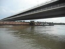
shipping


The Danube is already navigable for Danube navigation with vehicles below the size of the classic Ulmer Schachtel from Ulm. The 22 x 4 m locks on all barrages between Ulm and Kelheim are designed for this. This section of the river is a state waterway and can only be used with motorized vehicles with a special permit.
For large shipping, the Danube is only navigable from km 2415 near Kelheim (about 440 kilometers below the source). The 203 km long German route from Kelheim to the Austrian border is a federal waterway and the Regensburg Waterways and Shipping Office is responsible . From Kelheim to the Black Sea there are a total of 20 barrages with locks, six of them in Germany. With the Main-Danube Canal , which flows into the Danube at Kelheim, the Danube is also a continuous international waterway from the North Sea via the Rhine and Main to the Black Sea.
Various canal projects in the Alps , which would have connected the Danube to the Alpine region, remained unrealized. B. the Maloja-Inn Canal, which would have connected the Danube from Vienna, over the Inn and further over the Malojapass with Lake Como . The Splügen Canal over the Splügen Pass with Genoa and the Mediterranean as the final destination remained equally unrealized - the Danube would pass through u. a. Danube side canal, Lake Constance and Rhine were connected.
The Danube navigation distinguishes three sections on the navigable part of the Danube:
- Upper Danube , from Kelheim to Komárom / Komárno
- Middle Danube , from Komárom / Komárno to Drobeta Turnu Severin
- Lower Danube , from Drobeta Turnu Severin to the mouth
Historical shipping on the upper Danube
The Danube is one of the oldest and most important European trade routes. Already in prehistoric times it served as a transport route for merchandise such as furs, which were mostly still transported along the river with simple rafts. Shipping was already practiced in Roman times, even if until modern times boats that had reached their destination port after the long and at that time very dangerous journey were often dismantled and sold as timber. If the arduous and slow return journey on ships could not earn enough money, this was avoided. Typical for shipping on the Danube were therefore simple ship constructions such as Zillen (see also Ulmer Schachteln ) and Platten , which operated on the upper reaches from Ulm (on the Inn from Hall in Tirol) and reduced wood consumption compared to building rafts. Larger barges with lengths of up to 30 meters and two tons of payload, the so-called Kelheimer or Ulmer Ordinarischiffe, were occasionally pulled back upstream with worthwhile cargo such as wine and salt. As a rule, however, only small barges were pulled upstream with the belongings of the boatmen.
Boats could upstream only over the millennia towing along here Treppelpfade mentioned Leinpfade move forward. The boats were first pulled upstream by humans, and increasingly by draft animals from the 15th century onwards. These later ship trains were strictly organized and comprised up to 60 horses and just as many crews, as ships a Kelheimer (called Hohenau) or several (incidentally) and always several barges and flats as functional ships for ropes, horses and supplies. Because of the ramified river system with changing shoals, such a ship train was very slow. Often you only got a few kilometers in a day. Often the river had to be changed with the horses, weather and water conditions hindered progress.
Steamboat trip on the Danube
With the advent of steam shipping and later the locomotives , the decline of historical Danube shipping began. The last ship trains were pulled upstream around 1900. In 1812 the first Danube steamship was put into operation in Vienna. A short time later, in 1829, the first Danube steamship company was founded . This made the ships faster, for example the first steamship Franz I made the descent from Vienna to Budapest in 14 hours 15 minutes in 1830. The ascent from Budapest to Vienna took 48 hours 20 minutes. In September 1837 the first ship, the Maria Anna , sailed from Vienna to Linz. One of the last examples of this type of ship can be viewed in Regensburg as a museum ship. The middle to the end of the 19th century also saw the heyday of chain tugs , which pulled themselves up the river using steam engines on a chain that had previously been firmly laid in the river's fairway. Such chains were first laid for the Vienna – Pressburg route, but in 1891 also near Ybbs and Regensburg. In the Iron Gate (Djerdap), locomotives were used in the 20th century until the dam was built.
Waterway construction

Since the middle of the 19th century, attempts have been made to promote navigation on the Danube by correcting the mean water level with punctures , groynes and parallel works . In order to flood the Bavarian Kachlet, a chain of rocky reefs above Passau, the Kachlet barrage was completed in 1928 with what was then the largest hydroelectric power station. At the same time, a low water regulation began downstream of Regensburg with the aim of a fairway depth of at least 1.40 m. Four bottlenecks below Passau, which can only be navigated by a single ship, were removed by the Jochenstein barrage on the German-Austrian border, which went into operation in 1956. This noticeably improved the ships' travel time and energy requirements.
The first verifiable plan of a connection between the Rhine and the Danube goes back to Charlemagne in 793. He ordered the construction of the Fossa Carolina (Karlsgraben) . Between 1836 and 1846, in the course of industrialization, the Ludwig-Danube-Main Canal between Kelheim and Bamberg was realized with a length of 172.4 km. The idea of a waterway connection was only effectively implemented when the 171 km long Main-Danube Canal (MDK) was completed in 1992 . Between the confluence of the MDK in Kelheim and Regensburg, the barrages Bad Abbach and Regensburg were completed in 1978, parallel to the construction of the MDK to adapt it for large shipping. Until then, Regensburg was the terminus for Danube shipping. Below Regensburg, the Geisling barrage followed in 1985 and Straubing in 1995.
The Danube Canal in Vienna is not an artificial body of water, but a historical branch of the Danube. The Wiener Neustädter Canal is a historical artificial watercourse of local importance (commissioned in 1803, maximum length 63 km) for commercial transports to Vienna, which was never connected to the Danube. Since the Middle Ages there have been repeated efforts to connect the Danube with the Oder ( Danube-Oder Canal ) or Elbe ( Danube-Oder-Elbe Canal ). Except for a few short sections, however, this project was not implemented. In the last section of the river, the Danube-Black Sea Canal with its length of 64.4 km shortens the route into the Black Sea by around 240 km by bypassing the delta.
Danube shipping today
In addition to cargo shipping, there are almost 100 river cruise ships that set off for multi-day cruises mainly between Passau , Budapest and the Black Sea, and many day excursion ships that operate in Germany primarily in Passau ( Wurm & Köck ) and in Austria primarily in the Wachau ( DDSG Blue Danube ) are on their way. There are also countless small, private sports motorboats on the river. The Khan Asparu , a heavy-duty catamaran , operates between Widin and Passau .
Legal Regulations
Originally the Danube was an open trading river, usable for everyone, but every bank country took trade tariffs. In the Peace of Paris in 1856, the right to free trade on the Danube was codified for the first time and a European Danube Commission was founded, based on the provisions of the Vienna Congress Act of 1815 on free navigation. 120 years later, on August 18, 1948, at the Belgrade Conference, this right was re-established in the Convention on the Regulation of Shipping on the Danube : ships of all flags are allowed to sail on the Danube, only warships of foreign flags are allowed to sail on the Danube prohibited. International special electricity administrations were created for the area of the Iron Gate and the lower Danube. The Danube Commission monitors compliance with the provisions of the contract and the maintenance of the navigability . It also resolves the basic provisions for shipping on the Danube , which are to be made part of the regulations of the neighboring states and the special river administrations. Another component of the regulations are the respective special provisions for which the local authorities are responsible. In Germany the Danube Shipping Police Ordinance applies , in Austria the waterway traffic regulations .
bridges

More than 300 bridges cross the Danube between the source and the mouth. Two of the most famous bridges are the medieval Stone Bridge in Regensburg and the Chain Bridge in Budapest.
Kilometrage

The kilometers of the Danube and its entire river system are counted upstream. Official zero point of Kilometrierung is the old lighthouse of Sulina on the Black Sea. From kilometers 0 to 150, the route is given in nautical miles (0–81 nm). All backwaters also have their zero point at their mouth. With one exception: the Danube Canal in Vienna at Stkm 1933–1919.3 - 17 km long - is kilometered in the direction of the current.
Flood of wood
In the 18th and 19th centuries, the Danube was used as a transport route for wood from the Bohemian Forest, among others. Logs were washed from the Bohemian Forest via the Schwarzenberg canal into the Große Mühl , pulled out of the water there, loaded onto ships and then transported to Vienna , where they were sold as firewood. There were other larger Holzschmemmen from the Naarn, the Weitenbach and the Traisen.
fishing
The importance of fishing , from which the whole population lived in some places in the Middle Ages , declined sharply in the course of the 19th and 20th centuries. Only a few Danube fishermen are still active in Germany. In Austria there is still a modest fishing around Linz and Vienna. Fishing has a certain importance in the Danube Delta.
Viticulture


In some states there are wine-growing regions along the Danube .
Mainly Grüner Veltliner and Riesling are grown in the Wachau in Austria .
In Hungary wine is cultivated almost everywhere along the Danube between Visegrád and the southern border of the country, the capital of Hungarian wine was Vác . In the socialist era, the previously famous Hungarian wines lost a lot of their quality; Hungarian viticulture has been experiencing a renaissance since the 1990s.
The wine-growing region extends north into Slovakia with a focus on Devín (German: Theben ) near Bratislava and Štúrovo .
In the area around Ilok in Croatia and in the Fruška Gora near Ruma in Serbia, the grape varieties Traminer, Riesling, Burgundy and Graševina are mainly grown.
An economically insignificant curiosity and at the same time the last relic of the originally living culture of Baier wine , which dates back to the Romans, is the German wine-growing region near Bach between Regensburg and Straubing ( Regensburger Landwein ).
tourism
In addition to many famous and worth seeing individual destinations along the Danube, numerous Danube landscapes and national parks are of tourist importance, for example the Upper Danube Nature Park in Germany, the Wachau and the Donau-Auen National Park in Austria, the Iron Gate between Serbia and Romania and the transnational Danube Delta .
River cruise tourism is also important: in addition to the busy route from Vienna to Budapest , individual ships also travel from Passau to the Danube Delta and back. Over 70 cruise ships are in use during the high season . Especially on the non-navigable and therefore traffic-free Upper Danube, there are opportunities for canoe, paddle and boat tours.
The Danube region is not only of great tourist importance in terms of its historical and cultural significance and its scenic fascination, but also good infrastructure and the cycling, hiking and travel opportunities along the river attract international visitors. The Austrian Danube region alone can record around 14 million overnight stays and around 6.5 million arrivals per year. The Danube Cycle Path , the Donausteig and the Road of Emperors and Kings largely contribute to the tourist success of the Danube region.
Danube Cycle Path


The Danube Cycle Path , an international long-distance cycle route , runs along the Danube and is particularly popular in Germany and Austria. This runs from the source of the Danube to its confluence with the Black Sea and is one of the ten most popular German long-distance cycle routes.
Donausteig

In 2010 the Donausteig was opened - a long-distance hiking trail from Passau to Grein . The long-distance hiking trail is around 450 kilometers long and is divided into 23 stages. Five Bavarian and 40 Austrian municipalities are crossed. Popular landscape and viewpoints are among the highlights of the Donausteig, which largely runs along both banks of the Danube. A total of 41 official Donausteigrunden are signposted.
The road of emperors and kings
The road of emperors and kings is an international tourist road that leads from Regensburg via Passau , Linz and Vienna to Budapest . An international working group, short ARGE “The Danube Road of Emperors and Kings”, consisting of ten tourism organizations and shipping companies as well as cities, participates in the preservation of this common European heritage. The aim of this organization is the touristic preservation, revitalization and historical deposit of the river landscape and the cultural area near the Danube.
The so-called Road of Emperors and Kings begins in medieval Regensburg with its preserved old town, the stone bridge and the cathedral. The further course leads to Austria, to Engelhartszell. Austria's only Trappist monastery is located there . The Schlögener Schlinge , Linz, the European Capital of Culture 2009 with its contemporary cultural offerings, the Melk Abbey , the Danube and university city of Krems and the cosmopolitan city of Vienna are among the other highlights along the Danube. Before the Road of Emperors and Kings ends, it continues to the cultural metropolis of Bratislava and Budapest, which was regarded as Vienna's sister city during the times of the Danube monarchy.
Several famous rulers have traveled with their entourage on and along the Danube since Roman times and used the river as a travel and transport route. Due to the lack of well-kept roads, transport by land was considered very difficult, which is why the Danube has developed into the ideal travel route on the water. The Road of Emperors and Kings can therefore also be attributed to numerous historical highlights that have shaped the Danube to this day.
The tourist route owes its name, among other things, to the Emperor Friedrich I. von Barbarossa and the Crusaders as well as the English King Richard the Lionheart , who was imprisoned above the Danube in Dürnstein Castle. The Danube region experienced the climax of imperial journeys through the Habsburgs , who were crowned in Frankfurt am Main , stayed in Vienna and held the Perpetual Reichstag in Regensburg . Many famous castles, palaces, residences and stately monasteries were built by the rulers and still shape the architecture, inspired by shapes and colors, the Danube Baroque.
In the meantime, travelers can no longer just visit the water, but also by train, bike along the Danube Cycle Path or on foot over the Donausteig , the cities of Regensburg and Vienna, which have been declared World Heritage Sites by UNESCO, and the Wachau .
literature
- Office of Upper Austria. State government. Kulturreferat: The Danube: Facets of a European river. Catalog for the Upper Austrian State Exhibition 1994 in Engelhartszell, Landesverlag, January 1, 1994.
- Franz X. Bogner: The Danube from the air. From the source to Passau. Rosenheimer, Rosenheim 2008, ISBN 978-3-475-53877-3 .
- Christian Fridrich: Danube. Wieser, Klagenfurt 2012, ISBN 978-3-99029-014-9 .
- Melanie Haselhorst, Kenneth Dittmann: The Danube. From Kelheim to the Black Sea. 2nd Edition. Delius Klasing, Edition Maritim, Hamburg 2013, ISBN 978-3-89225-586-4 .
- Melanie Haselhorst, Kenneth Dittmann: Cruise Guide Danube - Passau to Black Sea. Edition Maritim / Delius Klasing, Hamburg 2011, ISBN 978-3-89225-642-7 .
- Claudio Magris: Danube. Biography of a river. Hanser, Munich / Vienna 1988, ISBN 3-446-14970-8 .
- Bernhard Schütz, Achim Bunz: The Danube: cultural treasures on a European river. Hirmer, Munich 2012, ISBN 978-3-7774-2331-9 .
- Michael Weithmann: The Danube. A European river and its three thousand year history. Pustet, Regensburg 2000, ISBN 3-7917-1722-7 and Styria, Graz 2000, ISBN 3-222-12819-7 .
- E. Klaghofer, K. Hintersteiner, W. Summer: Trends in soil erosion and sediment yield in the alpine basin of the Austrian Danube. In: Modeling erosion, sediment transport and sediment yield (PDF; 3.62 MB). Technical Documents in Hydrology, No. 60, pp. 195–203, UNESCO, Paris, 2002.
Historically (by date):
- Water trip from Augsburg to Vienna: together with a description of the peculiarities on the way; with 1 card. Frankfurt and Leipzig 1822. (digitized version)
- Ernst Neuffer: The latest illustrated Danube Guide from Passau to Sulina: a handbook for tourists along with a complete guide to Vienna and Budapest, as well as 6 maps of the Danube region. Vienna 1886. (digitized version)
- Panorama of the Danube from Ulm to Vienna. Recorded and drawn by Bernard Grueber, engraved by Henry Winkles . Regensburg, Manz around 1870 (New edition: With an introduction by Robert Wagner, (= Topographia Austriaca. Vol. 5). Academic printing and publishing establishment, Graz 1988, ISBN 3-201-01431-1 , ISBN 3-201- 01430-3 ).
- Albrecht Penck : Thal history of the uppermost Danube. In: Writings of the Association for the History of Lake Constance and its Surroundings. 28th year 1899, pp. 117-130. (Digitized version)
Web links
- Flood news service Bavaria Data on Bavarian rivers such as current water levels, reporting levels in the event of flooding, long-term runoff data, catchment area
- current water levels of the Danube in Austria via donau Österreichische Wasserstraßen-Gesellschaft mbH
- Office of the Upper Austrian Provincial Government Water level report for Upper Austria
- Office of the Lower Austrian Provincial Government Water levels and flow rates including forecasts for Lower Austria
- DanubeCat search catalog with information about companies, institutions, initiatives and projects related to the Danube and the Danube region
- ARGE Deutsche Donau Touristic Working Group of Cities and Counties
- ARGE Danube Austria Tourist Working Group Danube Austria
- donaukarte.eu - Danube Tourist Map
- young-donau.info
- Danube TV
- Danube - what not everyone knows about Europe's second longest river
Individual evidence
- ↑ a b c d Federal Ministry for the Environment, Nature Conservation and Nuclear Safety: Hydrological Atlas of Germany, Freiburg i. Br. 2003.
- ^ Deutsches Gewässerkundliches Jahrbuch Danube region 2006 Bavarian State Office for the Environment, p. 79, accessed on October 4, 2017, at: bestellen.bayern.de (PDF, German, 24.2 MB).
- ↑ a b F. Neppel, p Somoqyi, M. Domokos: Palaeogeography of the Danube and it's catchment , Water Resources Research Center (VITUKI), Budapest 1999
- ^ Hubert Thébault: La Tribu de Dana. , in: Christian-Louis Eclimont (Ed.): 1000 Chansons françaises de 1920 à nos jours. Flammarion, Paris 2012, ISBN 978-2-0812-5078-9 , p. 876
- ↑ T. Provoost: De Ijzer: Een Small Stroom Met Een Groot Verleden , PDF Online ( Memento of 29 September 2007 at the Internet Archive ). In: Water No. 97 - November / December 1997, accessed April 8, 2013.
- ^ Hans Bahlow: Germany's geographical world of names. Etymological lexicon of river and place names of ancient European origin . Suhrkamp, Frankfurt am Main 1985, pp. 239f.
- ↑ After deducting the length of the Breg of 45.93 km, general information about the Danube - Danube Commission - Danube Commission - Commission du Danube - Дунайс. In: danubecommission.org. Retrieved October 31, 2018 .
- ↑ General information about the Danube, The most important tributaries , website of the Danube Commission . Retrieved March 29, 2011.
- ↑ a b c d e Baßler u. a .: Danube from Ulm to Passau , website of the German Rowing Association . Retrieved March 29, 2011.
-
↑ a b c d e f
Estimated using neighboring bridges.
Source: List of Danube bridges ( memento of August 11, 2013 in the Internet Archive ) (PDF; 84 kB). Status March 2010. Website of via donau . Retrieved March 29, 2011. - ↑ Extreme Hydrological Phenomena in the Vedea Hydrological Basin - Borcan - Lucrările Seminarului Geografic "Dimitrie Cantemir". In: seminarcantemir.uaic.ro. Retrieved October 31, 2018 . (PDF; 487 kB) Seminarul geografic “D. Cantemir ", 28, 2007 (mean discharges of the gauges Alexandria on the Vedea and Teleormanu on the Teleorman tributary added, 86% of the basin)
- ↑ a b Waterways Directory E, Ser. No. 6 of the Chronicle ( memento of July 22, 2016 in the Internet Archive ) , Federal Waterways and Shipping Administration, accessed on April 8, 2013.
- ↑ a b c Lengths (in km) of the main shipping routes (main routes and certain secondary routes) of the federal inland waterways ( memento of January 21, 2016 in the Internet Archive ), Federal Waterways and Shipping Administration
- ↑ See also entry in Wiktionary : “ Iller, Lech, Isar, Inn, flow right towards the Danube. Altmühl, Naab and Regen come towards her from the left. "
- ^ Daniel Steffen: How Wigg Bäuml pays homage to the Danube. In: Mittelbayerische.de. September 9, 2016, accessed August 2, 2018 .
- ↑ Round trips on the Danube: Insel Wörth, Freyenstein, Grein, Greinburg, Burg Werfenstein , donauschiffahrt-ardagger.at, accessed on April 8, 2013.
- ↑ sketch seepage , aachquelle.de, accessed on April 8, 2013.
- ↑ Peace Treaty of Versailles. June 28, 1919. Chapter III. Article 331
- ^ Rainer Ehm: On the water and in the air . In: Kunst und Gewerbeverein Regensburg eV (ed.): It is a pleasure to live! The 20s in Regensburg . Dr. Peter Morsbach Verlag = Regensburg, 2009, ISBN 978-3-937527-23-9 , pp. 65, 66 .
- ↑ diepresse.com: The Danube was a place of longing
- ^ Paul Arnold, Harald Küthmann, Dirk Steinhilber: Large German coin catalog from 1800 to today , Augsburg 1997: ZB, p. 54, Bavaria, no.69, Danube gold ducats from 1830.
- ↑ Svetozar Radojčić 2008: Ideja o u gradu savršenom državi kneza Lazara i despota Stefana Lazarevica . Zograf, 32, 5-12 ( SCIndeks: PDF ( Memento from October 5, 2013 in the Internet Archive ))
- ↑ Ivan Biliarsky 2010: Old Testament models and the State in Early Medieval Bulgaria. In: Paul Magadlino & Robert Nelson (eds.): The Old Testament in Byzantium . Dumbarton Oaks, Washington 2010, ISBN 978-0-88402-399-9 , pp. 255-277.
- ↑ Jelena Erdeljan 2011: New Jerusalems as New Constantinoples? Reflections on the principles of Translation Constantinopoles in Slavia Orthodoxa. ΔΧΑΕ 32: 11-18. [1]
- ↑ TV report on the Danube habitat, NDR, summer 2016.
- ↑ The natural landscape of the Danube at www.bund.net.
- ^ Species in Danube , fishbase.org, accessed April 8, 2013.
- ↑ Herpetofauna of the Danube Delta (PDF; 265 kB) , herpag-hdn.amphibien.at, accessed on April 8, 2013.
- ^ Donauleiten nature reserve - from Passau to Jochenstein ( memento of February 21, 2011 in the Internet Archive ) , accessed on April 8, 2013.
- ↑ District Office Passau: Naturerlebnis Donautal , 2002, Morsak Verlag Grafenau
- ↑ Ulrich Schulte & Guntram Deichsel (2015): Wall lizards introduced into Germany - an overview with recommendations on how to deal with nature conservation. Mertensiella 22: 75-85.
- ^ Werner Kremm: Expansion of the Eisernes Tor nature park , banaterzeitungonline
- ^ Animals, Birds and Fish ( Memento of March 29, 2010 in the Internet Archive ) , rotravel.com, accessed on April 8, 2013.
- ↑ grabmayer ( memento of July 6, 2011 in the Internet Archive ) , accessed on April 8, 2013.
- ↑ Blinker, September 2008 edition, pp. 90–94.
- ↑ The Amazon in the heart of Europe in Pester Lloyd on October 12, 2009, accessed on February 20, 2010.
- ^ Joint Danube Survey 2 Final Scientific Report , icpdr.org (PDF; 8.4 MB), accessed April 8, 2013.
- ↑ Continuous cyanide contamination , Berliner Zeitung
- ^ Karl Wachter: Three years after Baia Mare - a review ( Memento from May 13, 2011 in the Internet Archive ) (PDF; 313 kB), accessed on April 8, 2013.
- ^ The Danube: Destruction of Valuable Natural Areas, wwf.de, accessed on December 15, 2014
- ↑ More plastic than young fish , Badische Zeitung ( dpa ), March 7, 2014, accessed on March 22, 2014
- ↑ More plastic than juvenile fish in the Danube. ( Memento of March 10, 2014 in the Internet Archive ) at: enveya.com , March 9, 2014, accessed on March 10, 2014.
- ↑ On the dirty, brown Danube , diepresse.com
- ^ About - The Joint Danube Survey 3 , danubesurvey.org, accessed March 24, 2015
- ↑ Donauwörth Water Management Authority on shipping obstacles (page can no longer be accessed)
- ^ Website of the Donau-Schifffahrtsmuseum , dsmr.de, accessed on April 8, 2013.
- ↑ a b Danube Commission - Austria Forum: AEIOU , austria-forum.org, accessed on April 8, 2013.
- ↑ Convention on the Regulation of Navigation on the Danube (PDF), danubecommission.org, accessed on April 8, 2013.
- ↑ Basic provisions for shipping on the Danube , 2018, Danube Commission (Ed.) (PDF; 9.5 MB)
- ↑ vineyards of Fruska Gora | Beautiful Serbia ( memento February 7, 2013 in the Internet Archive ) , voiceofserbia.org, accessed April 8, 2013.
- ^ "ARGE Donau Österreich" ( Memento from March 13, 2014 in the Internet Archive ). Press release from ARGE Donau Austria. Retrieved March 12, 2014.
- ^ The ADFC bicycle travel analysis 2013 - figures, data and facts ( Memento from June 18, 2017 in the Internet Archive ). ADFC website. Retrieved March 12, 2014.
- ↑ The Donausteig . Website of the Tourist Information Passauer Land, accessed on March 12, 2014.
- ^ "Princely journeys from Regensburg via Linz and Vienna" ( Memento from March 13, 2014 in the Internet Archive ). Press release Linz Tourist Board, accessed on March 10, 2014.
- ↑ The International Working Group. Danube - road of emperors and kings. ( Memento from March 13, 2014 in the Internet Archive ) Press release from the Linz Tourist Office, accessed on March 12, 2014.
- ↑ Oscar Ludwig Bernhard Wolff: The Danube, its residents, banks, cities, castles and palaces. J. J. Weber's publishing house, Leipzig 1843.