Wörnitz
| Wörnitz | ||
| Data | ||
| Water code | EN : 118 | |
| location |
Franconian Keuper-Lias-Land
|
|
| River system | Danube | |
| Drain over | Danube → Black Sea | |
| source | In Schillingsfürst , Frankenhöhe 49 ° 16 ′ 57 ″ N , 10 ° 15 ′ 25 ″ E |
|
| Source height | approx. 490 m | |
| muzzle | In Donauwörth in the Danube Coordinates: 48 ° 42 ′ 57 ″ N , 10 ° 46 ′ 59 ″ E 48 ° 42 ′ 57 ″ N , 10 ° 46 ′ 59 ″ E |
|
| Mouth height | approx. 395 m | |
| Height difference | approx. 95 m | |
| Bottom slope | approx. 0.72 ‰ | |
| length | 131.8 km | |
| Catchment area | 1,686.3 km² | |
| Discharge at the Gerolfingen A Eo gauge : 586 km² Location: 69.2 km above the mouth |
NNQ (07/19/1964) MNQ 1963–2006 MQ 1963–2006 Mq 1963–2006 MHQ 1963–2006 HHQ (12/21/1993) |
100 l / s 776 l / s 5.1 m³ / s 8.7 l / (s km²) 86 m³ / s 168 m³ / s |
| Discharge at the Harburg A Eo gauge : 1569 km². Location: 19.3 km above the mouth |
NNQ (08/01/1964) MNQ 1940–2006 MQ 1940–2006 Mq 1940–2006 MHQ 1940–2006 HHQ (12/21/1993) |
502 l / s 2.02 m³ / s 11.4 m³ / s 7.3 l / (s km²) 148 m³ / s 444 m³ / s |
| Discharge at the mouth of the A Eo : 1,686.3 km² |
MQ Mq |
12.2 m³ / s 7.2 l / (s km²) |
| Left tributaries | See → tributaries | |
| Right tributaries | See → tributaries | |
|
Wörnitz near Donauwörth |
||
The Wörnitz is an approximately 132 km long left and northern tributary of the Danube in Bavaria .
Surname
The name in the 11th century as Werinza narrated in the 12th century, wrote Warinza . There are two possible explanations for this name. In 1950 the name researcher Joseph Schnetz led the name back to the Indo-European root ver with the basic meaning “(to) turn, (to) turn”, followed by the participle ending -entia . Accordingly, Wörnitz means "the curving, winding one". According to the name researcher Wolf-Armin von Reitzenstein , it is based on the Indo-European root uer , which means water, from which an -nt suffix was derived. However, this declaration was rejected by Schnetz.
The river gave names to several communities: Wörnitz , Wörnitzhofen , Wörnitzostheim and Wörnitzstein .
geography
source
The Wörnitz rises in Schillingsfürst on the Frankenhöhe from a contained well and runs from there in a fairly steady course in southern to eastern directions.
course
First it moves south through the municipality of Wörnitz through a very rural meadow valley accompanied by wooded hills and on this route takes the Ampfrach and the Zwergwörnitz from the right . At river kilometer 115.62 in the Feuchtwangen village of Reichenbach , a gauge measures the flow reached up to that point. From the medieval town of Dinkelsbühl with its closed city wall, a south-east-facing section begins that extends to the edge of the Nördlinger Ries , in which many of the tributaries feed ponds, which sometimes line up in close succession along the course of the tributaries. In the meantime, running more towards the east, it first reaches Wilburgstetten , where it - again from the west - meets the Rotach .
From here it moves east-north-east to Wittelshofen at the west foot of the Hesselberg , where the largest tributary on the upper course, the Sulzach , flows into it, whose near and almost parallel course east of its previously larger left tributaries has denied it. From there it continues in the direction of the approaching Sulzach to the east-southeast and reaches Wassertrüdingen near the other end of the small Hesselberg massif , where it suddenly turns south from the north shortly before the Lentersheimer Mühlbach creek. On the south course it enters the wide flat landscape of the Nördlinger Ries near Auhausen in the northeast .
In the north of it she passes the small residential town of Oettingen . Before it reaches the southeastern edge of the Ries, the Eger flows towards it from the right , which drains the greater part of the flat, flat landscape in the west and, after its formation, pulls it across the Württemberg state border through Nördlingen . Then it breaks in a narrow, winding valley running southeast through the Jura on the border of the eastern Swabian Alb and the southwestern Franconian Alb , in which the town of Harburg lies on the bank. Soon afterwards, after a run of over 130 km, it joins the Danube from the left in Donauwörth in Bavarian Swabia .
Catchment area
The Wörnitz drains an area of over 1680 km² to the south-southeast to the Danube. It covers a large part of the western Frankenhöhe , on the eastern edge of which it initially runs to the Central Franconian Basin , before it flows through the Central Franconian Basin before Dinkelsbühl, then to Wilburgstetten through the foreland of the Southern Franconian Jura , which it finally leaves on the southern course. It changes there to the Nördlinger Ries and is then with its valley through the Jura the westernmost part of the southern Franconian Alb on the border with the Riesalb in the west, which in turn is part of the Swabian Alb .
In the north-west and north of its catchment area near Schillingsfürst, the Tauber to the Main competes on a small stretch beyond the watershed , while the Altmühl , which flows roughly parallel to the Danube, competes on most of the north-eastern border of its catchment area . In the west of it the Jagst moves to the Neckar .
The Wörnitz is part of the old, south-east oriented tributary system to the Danube, which is expressed in a very even slope curve of the river and a low mean bed slope of about 0.7 ‰. The also Danubian Altmühl in the northeast has a value of around 0.5 ‰, while the Rhenish- oriented neighboring rivers Jagst in the west and Tauber in the northwest reach or exceed twice the value of the Wörnitz.
It is the first larger river that still drains to the south-east to the Danube, which one encounters coming from the direction of the central Neckar near Heilbronn when one crosses the south-west German plains in an easterly direction . A long geological time ago, the Kocher and Jagst , which previously ran to the Neckar, still flowed in this direction to the Danube. A clear indication of the gain of the Rhine system can be seen in the Schillingsfürster Ursprung. To the right and northwest of the uppermost course, the Frankenhöhe falls steeply beyond a small terrain wave in the town for the first 2 km over the Katzenklinge of the Davidsbach to the Hohenlohe Plain, exposed by the violently attacking Rhenish erosion, by more than 80 meters in altitude, while the Wörnitz on its more than 130 km run does not even show a 100 meter drop.
colonization
In the valley there are mostly only small villages and farms, the only larger cities before the mouth of Donauwörth on the Danube with less than 20,000 inhabitants are Dinkelsbühl with less than 12,000 and Wassertrüdingen , Oettingen and Harburg with between 5,000 and 6,000 inhabitants. Even of these, a noticeable part lives outside the centers in many small hamlets and individual farms, because the communities and cities in this sparsely populated landscape encompass large areas in agricultural and forestry areas.
Tributaries
List of the over 10 km long tributaries of the Wörnitz in the order of their confluence, with lengths - mostly on the hydrological main line with possibly changing name segments - and catchment areas. Data where this exists, after the main article.
Wörnitzquelle in Schillingsfürst on Dombühler Straße at about 490 m above sea level. NN .
Upper course to the south-southeast to the east bend near Wilburgstetten :
- Ampfrach , from the right across from Feuchtwangen - Reichenbach , about 10.5 km.
- Zwergwörnitz , from the right to 440.8 m above sea level. NN between Schopfloch and Lehengütingen , 16.0 km and 23.1 km².
- Rotach , from the right near Wilburgstetten , 20.8 km and 87.7 km².
East run to Wassertrüdingen :
- Sulzach , from the left near Wittelshofen below the Wörnitzbrücke, 40.6 km and 190.4 km².
- Lentersheimer Mühlbach , from the left close to the Wassertrüdinger Oberaumühle , 18.2 km and 92.1 km². With headline name Lochgraben , then Eglesgraben .
South run to the edge of the Frankenalb :
- Augraben , from the right near Oettingen , 11.3 km and 15.4 km².
- Mühlbach , from the right near Munningen , 14.5 km and 26.1 km².
- Grimmgraben , from the right near Munningen, 10.4 km and 26.7 km². (Length calculated with the longer upper course of the right-hand Grimmgraben .)
- Rohrach , from the left near Wechingen , 24.1 km and 49.7 km². Flows through the Hahnenkammsee on the middle course .
- Rodelbach , from the left at Alerheim at 406.4 m above sea level. NN , 13.0 km and 52.1 km².
- Schwalb or Schwalbach , from the left at Bühl im Ries , 14.2 km and 31.2 km².
- Eger , from the right at Heroldingen to over 405 m above sea level. NN , 36.9 km and 248.4 km².
South-eastern breakthrough valley through the Frankenalb to the Danube:
- Ellerbach , from the left at Ebermergen at less than 403 m above sea level. NN , 11.9 km and 47.4 km².
- Kaibach , from the left in Donauwörth , 11.1 km and 21.1 km².
Mouth of the Wörnitz in Donauwörth at about 395.1 m above sea level. NN from the left into the Danube .
Drain

The mean discharge at the Harburg gauge (river kilometers: 19.3) is 11.3 m³ / s, the mean flood discharge is 147 m³ / s. The highest measured discharge on December 21, 1993 was 444 m³ / s. Such water levels lead to wide embankments, which can make it necessary to close the B 25 . At the confluence with the Danube, the Wörnitz has an average discharge of a good 12 m³ / s.
environment
River and valley nature

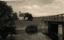
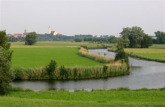
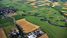
The above-mentioned slight gradient of an old river also explains the character of the watercourse and its valley. The Wörnitz runs over long stretches of its course with numerous meanders through a flat and damp meadow hollow, often accompanied by backwaters and dead straight drainage ditches, which should make the meadows usable for agriculture. The surface of the river is often mirror-smooth and does not show any movement at first glance. Incoming brooks are often dammed into ponds, some of which dissolve into a chain of such water surfaces. In some places there are old mill buildings on the banks or on side canals.
Forest often grows on the low heights to the neighboring valleys that accompany the river basin; only on the route through the flat ream does the right side remain continuously open.
Only very recently in the breakthrough valley through the Jura near Harburg do high and steep valley flanks appear for the first time.
Leisure and Tourism
The Wörnitz is known for its meandering course made up of a multitude of loops and arches, which is why it is also called the "snake river". Because of its pure water and its leisurely flow speed, there are several river swimming pools and bathing areas on the Wörnitz , including in Dinkelsbühl (Wörnitzstrandbad), Wassertrüdingen (Wörnitzbad) and Oettingen (Wörnitzfreibad). Because many mills are located on the river and their weirs, unlike the Altmühl, are difficult to carry around , the Wörnitz is difficult to navigate by canoe.
See also
literature
- Johann Kaspar Bundschuh : Wernitz . In: Geographical Statistical-Topographical Lexicon of Franconia . tape 6 : V-Z . Verlag der Stettinische Buchhandlung, Ulm 1804, DNB 790364328 , OCLC 833753116 , Sp. 172 ( digitized version ).
Web links
- Course of the Wörnitz on the BayernAtlas
- Bavarian State Office for the Environment, flood intelligence service
-
Geoportal Baden-Württemberg ( information ), especially with the partial maps / layers
- "LUBW-FG10": River 1: 10,000
- "LUBW-GEZG": water catchment areas
- Wörnitz at openstreetmap.org
Individual evidence
- ↑ a b Directory of brook and river areas in Bavaria - Danube river area from source to Lech by the Bavarian State Office for the Environment, as of 2016 (PDF; 2.3 MB)
- ^ Deutsches Gewässerkundliches Jahrbuch Danube region 2006 Bavarian State Office for the Environment, p. 116, accessed on October 4, 2017, from: bestellen.bayern.de (PDF, German, 24.2 MB).
- ^ Deutsches Gewässerkundliches Jahrbuch Danube region 2006 Bavarian State Office for the Environment, p. 115, accessed on October 4, 2017, from: bestellen.bayern.de (PDF, German, 24.2 MB).
- ↑ a b Gauge value Harburg increased by the discharge of the remaining catchment area (6.4 l / s · km² to 116.8 km²), determined for the intermediate catchment area of the gauges Dillingen (Danube), Wittislingen (Egau), Pfaffenhofen (Zusam), Druisheim ( Schmutter), Harburg (Wörnitz) and Donauwörth (Danube)
- ^ Joseph Schnetz: River names of Bavarian Swabia in their meaning for namology, history and landscape research. Augsburg 1950, pp. 89-92.
- ^ Wolf-Armin von Reitzenstein : Lexicon of Franconian place names. Origin and meaning . Upper Franconia, Middle Franconia, Lower Franconia. CH Beck, Munich 2009, ISBN 978-3-406-59131-0 , p. 247 ( limited preview in Google Book search).
- ^ Wolf-Armin von Reitzenstein: Lexicon of Bavarian place names. Origin and meaning. 2nd Edition. Munich 1991, p. 419; Lexicon of Swabian place names. Origin and meaning. Munich 2013, p. 427.
- ↑ https://www.pegel-alarm.de/pegel-details/11802509-reichenbach-woernitz/
- ↑ Wolf-Dieter Sick : Geographical land survey: The natural space units on sheet 162 Rothenburg o. D. Deaf. Federal Institute for Regional Studies, Bad Godesberg 1962. → Online map (PDF; 4.7 MB)
- ^ Franz Tichy : Geographical Land Survey: The natural spatial units on sheet 163 Nuremberg. Federal Institute for Regional Studies, Bad Godesberg 1973. → Online map (PDF; 4.0 MB)
- ↑ Ralph Jätzold: Geographical land survey: The natural space units on sheet 172 Nördlingen. Federal Institute for Regional Studies, Bad Godesberg 1962. → Online map (PDF; 3.9 MB)


